Coupled computer modeling, which involves combining models of different physical processes, can be an effective way to predict coastal flooding. This is because coastal flooding is caused by a combination of factors, such as storm surge, wave action, tide, and precipitation, which interact with each other in complex ways.
Hurricane Florence, which made landfall as a Category 1 storm in North Carolina in 2018, broke rainfall records and caused catastrophic 500-year flooding occurrences along the Cape Fear River Basin.
This is precisely the kind of meteorological occurrence that Z. George Xue of the LSU Department of Oceanography and Coastal Sciences (DOCS) thinks his unique coupled computer modeling approach may more accurately predict, helping communities prepare for disasters. Xue said as far as he knows, his lab is the only one using this technique.
The Hurricane Florence events were used in a paper recently published by Xue, DOCS graduate student Daoyang Bao, and the rest of their research team in the Journal of Advances in Modeling Earth Systems to show the viability of this novel technique.
According to John C. Warner of the US Geological Survey, another study collaborator, increasing the accuracy of flooding projections can aid in hurricane preparedness. “More accurate forecasts can help coastal managers to better alert communities of impending storms.”
According to Xue, this innovative coupled modeling technique may also have long-term advantages for communities.
“Our model can identify which region is most vulnerable in terms of compound flooding and provide not only short-term forecasts but also scenario analysis regarding future climate and sea level conditions,” he said.
I have been trying to build a ‘closed cycle’ modeling system that can integrate atmosphere, ocean and river processes in the land-estuary-ocean continuum. This new model closes the loop by coupling the river and land surface processes with that from the ocean side.
Z. George Xue
The complexities of compound flooding
In a compound flooding event, two or more causes of flooding in this case, rivers inundated with rains and the building storm surge from the hurricane converge to cause flooding. This is what happened along the coast during Hurricane Florence.
It is a complicated system that is challenging to model using the conventional river and ocean models since neither adequately reflects how the various sources of water interact with one another.
In linked modeling, river and ocean models are combined and run simultaneously so that one receives input from the other. This mimics the circumstances of a compound flooding event, in which a hurricane’s storm surge and rain-induced flooding from the storm’s advance inland collide over a coastal location.
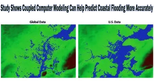
Xue and his group paired an ocean model with a river model using data gathered during Hurricane Florence as a validation of model performance. They compared the simulation’s results to those of a more conventional “linked” model, which runs two simulations simultaneously, and to information received from various monitoring stations in the Cape Fear region throughout the actual hurricane.
The study discovered that coupled models gave noticeably better results. At the head of the Cape Fear Estuary, simulated water levels were 20–40% more accurate than those generated by the connected model. Additionally, this is the first time that the quantitative diagnosis of the impact of storm surges and flash floods on compound flooding has been made.
Xue said this coupled model represents a new stage in an idea he’s been working on for nearly 20 years.
“I have been trying to build a ‘closed cycle’ modeling system that can integrate atmosphere, ocean and river processes in the land-estuary-ocean continuum,” Xue said. “This new model closes the loop by coupling the river and land surface processes with that from the ocean side.”
Overall, coupled computer modeling is a powerful tool for understanding and predicting coastal flooding. However, it should be noted that coupled models are complex and require a lot of computational resources and expertise to set up and run.