Definitions of geomorphology according to scientific nature :-
* Geomorphology is the study of landforms , and in particular their nature, origin, processes of development and material composition .
* Geomorphology is the study of the surface of the Earth. Classically, geomorphologists have studied land forms, which are shapes that have been categorized or named by geomorphologists or other Earth scientists.
* Geomorphology is the scientific study of the geometric features of the earth’s surface. Although the term is commonly restricted to those landforms that have been developed at or above sea level, geomorphology includes all aspects of the interface between the solid earth, the hydrosphere and the atmosphere. Therefore, not only are the landforms of the continents and their margins of concern, but also the morphology of the sea floor.
* Geomorphology is best and most simply defined as the study of landforms. Like most simplistic definitions, the actual meaning is somewhat vague and open to interpretation
River engineering and morphology
For river managers and designers of hydraulic structures, WL | Delft Hydraulics can provide state-of-the-art technology for regulation and canalisation of rivers, river morphology and sediment-transport, hydraulics and hydrodynamics in rivers and canals, hydraulics of structures, inland waterway transport, and closures and protections.
We can help solve problems regarding maintenance, management and sustainable development, and initiate new and cost-saving techniques through integration of various skills. A number of experimental facilities and numerical models are at our disposal. Extensive basic and applied research programs are continuously being conducted in order to maintain a high level of technical expertise.
Natural water systems are adapted by man to make a more profitable use of the water or to limit hindrance related to excessive natural fluctuations. Storing, guiding or sluicing water and retaining water levels are measures which can enhance irrigation, drainage, navigation, energy production, drinking water supply, fishery, flood control, recreation, ecology and environmental control. To achieve these goals tailored river engineering works are designed and constructed. A wide range of measures to control water have been developed, while new measures are concieved to reconcile the often conflicting demands on water systems.
WL | Delft Hydraulics’ approach is to apply in-depth knowledge of hydraulic and morphologic processes to assist the governmental or corporate client in carefully tuning the type, location and sizes of the river engineering works to the demands put on it. Both the proper functioning of a measure itself and as part of the overall system are important points of attention. Hydraulics, hydrodynamics, river morphology, and mechanical engineering are the core knowledge areas, augmented by experience with related phenomena, knowledge of navigation, operational aspects, etc.
List of rivers in Bangladesh
Bangladesh is a riverine country. Most of the country’s land is formed through silt brought by the many hundreds of rivers that flow through it. Following is a list of some of the major rivers of Bangladesh:
• Brahmaputra River
• Buriganga River
• Dhaleshwari River
• Feni River
• Gorai-Madhumati River
• Jamuna River
• Karnaphuli River
• Mahananda River
• Meghna River
• Muhuri River
• Naf River
• Padma River
• Pusur River
Highlights on a few number of river Brahmaputra River
The Brahmaputra is one of the major rivers of Asia. In Sanskrit, it means “son of Brahma”.It originates in the Himalayan mountains in western Tibet, in China and flows 2900km into the sea in the Bay of Bengal in Bangladesh. It is called Tsangpo in Tibet, Siang in Arunachal Pradesh and one of its main branches is called Jamuna in Bangladesh. Old sanskrit calls it Lauhitya and the people of the Brahmaputra valley calls it Luit.
This river eventually meets the Ganges (called Padma in Bangladesh) and Meghna rivers to form the largest river delta in the world, most of which is in Bangladesh. It is one of the few rivers in the world that exhibit a tidal bore. Most Indian rivers bear the name of a female. But this one has a rare name of Male. (Brahmaputra is a male name in India since putra in Indian language means ‘son’).
It is navigable for most of its length and the lower reaches are sacred to Hindus. The river is prone to catastrophic flooding in spring when the Himalayan snows melt.
The Buriganga River (old Ganges)is the main river flowing beside of Dhaka city, capital of Bangladesh.
Dhaleshwari River
Dhakeshwari River, about 160 Km long, a distributary of the Jamuna River in central Bangladesh. It starts off the Jamuna near the Northwestern tip of Tangail District. After that it divides into two branches. The north branch retains the name Dhaleshwari andmerges with the other branch, the Kaliganga River at the southern part of Manikganj District. Finally the merged flow meets the Shitalakshya River near Narayanganj District. The combined flow go southwards to merge into the Meghna River.
Feni River
Feni River is a river in south-eastern Bangladesh. It flows into the Bay of Bengal near the Feni district.
Gorai-Madhumati River
The Gorai-Madhumati River is one of the longest rivers in Bangladesh and a tributary of the Ganges.
Jamuna River
Jamuna River is one of the three main rivers of Bangladesh. It meets the Padma River near Goalondo and flows as Padma until it meets the Meghna River near Chandpur. After that, it flows into the Bay of Bengal as the Meghna River.
Karnaphuli River
Karnaphuli (also spelt Karnafuli) is a river in the south-eastern part of Bangladesh. Originating from the Lushai hills in Mizoram, India, it flows through Chittagong Hill Tracts and Chittagong into the Bay of Bengal. A large hydroelectric power plant using Karnaphuli river was built at Kaptai during the 1960s. The mouth of the river hosts Chittagong sea port, the main port of Bangladesh.
Legend has it that a princess from neighboring Arakan (now in Myanmar) fell in love with a tribal prince of Chittagong. The lovers were once enjoying a moonlit boatride on the river. While admiring the reflection of the moon dancing on the rippled water surface, the princess leaned slightly and a flower tucked in the hair over her ear by the prince suddenly fell into the river. The princess was grief-stricken at losing the flower, which she held very dear as a present from her charming prince. She immediately jumped into the river to retrieve the flower but could not. Instead she was carried away by the fast-flowing current and vanished in the river. The prince dived into the river to rescue the princess but in vain. Out of sorrow he drowned himself in the river to unite with the princess after death. This tragedy gave the river its name Karnafuli from the word ‘karnaphul’ meaning ‘flower adorning the ear’. The river is known to the Marma tribe as the Kynsa Khyong.
Mahananda River
The Mahananda River is a river the originates in the district of Darjeeling in West Bengal in the Himalayas. It flows through northern part of West Bengal, Bihar in India and Bangladesh. It again enters India in the Malda district of West Bengal before entering into Bangladesh to join the Ganges near the town of Chapai Nawabganj. This river is mainly fed by rainwater. During summer or winter it has very low water level and during monsoon it carries large amount of rainwater often causing floods. Some major places by the side of the river are Siliguri and Malda both in West Bengal, India
Meghna River
Meghna river is an important river in South Asia, one of the three rivers responsible for creating the largest delta on earth, most of which is Bangladesh. Meghna originates from the hilly regions of eastern India, and flows through Bangladesh, meeting the river Padma near Chandpur, Bangladesh. The joint river is known as Meghna and ultimately flows into the Bay of Bengal near Bhola, Bangladesh.
Muhuri River
Muhuri River one of the trans-boundary rivers of Bangladesh. The river takes its rise on the Lushai Hill of Tripura in India and enters Bangladesh through Parshuram upazila of Feni district after flowing over the hilly regions of India. As such the river is wild in nature and often causes flash floods. At some places it demarcates the boundary between India and Bangladesh and falls into the Bay of Bengal after dividing the Feni and the Chittagong district.
Before 1975, the Indian government constructed an impermeable spur on the river to save the Belonia town of Tripura State from the erosion of the river. But afterwards it has been decided in a meeting of joint river commission that none of the countries can construct spur or groyen on the river. The islands or chars formed in the Muhuri river are partly controlled by India and partly by Bangladesh.
The Muhuri is not wide enough and it is only 150 to 200 metres wide. But the width increases towards the sea. The depth of the river is also very little and people can cross it on foot during the lean period. Close to the sea, the river is under tidal influence.
There is a closure dam on the river about 4 km upstream from the estuary for irrigation purpose and a 20-vent regulator has also been constructed. During high tide, the dam along with the regulator controls the influx of saline water.
Naf River
Naf River is a river marking the border of Bangladesh and Myanmar.
It is an elongated estuary in the extreme southeast of Cox’s Bazar district dividing the district from Arakan, Myanmar. It rises in the Arakan hills on the southeastern borders of the district and flows into the Bay of Bengal. Its width varies from 1.61 km to 3.22 km. The river is influenced by tide. Akyab in Myanmar is on the eastern bank and Teknaf upazila of Cox’s Bazar district is on the western bank of the river.
Padma River
The Padma is a major river in Bangladesh. It is the main distributary of the Ganges River originating from the Himalayas. It enters Bangladesh from India near Chapai Nababganj. It meets the Jamuna river near Aricha, retains its name, but finally meets with the Meghna River near Chandpur and takes the name Meghna before flowing into the Bay of Bengal.
Rajshahi, a major city in southwestern Bangladesh, is situated on the bank of the Padma.
BANGLADESH AND THE BRAHMAPUTRA RIVER
Bangladesh is situated in the Bay of Bengal in close proximity to India, Bhutan, Burma and Nepal (figure 3.1). The majority of the country consists of large alluvial river plains formed by the Brahmaputra, Ganges and Meghna rivers. Bangladesh covers an area of 143,998 km2 and can be generally categorised as having a humid tropical climate with the south eastern corner having a tropical rainforest climate. The Brahmaputra River is the largest sand-bedded braided river in the world in terms of catchment area, discharge and sediment load. Its catchment area covers 666 000 km2, incorporating areas of Tibet, Bhutan, China, India and Bangladesh (figure 3.1). The catchment area receives intense rainfall during the summer monsoon which together with snowmelt in the Himalayas contributes to a mean peak annual discharge of 65,500 m3/s.
REGIONAL PHYSIOGRAPHY
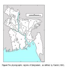
Spate (1954) was the first author to delineate physiographic regions in Bangladesh, he outlined five physiographic regions in the Bengal basin, three of which fell in Bangladesh. Johnson (1957) took the regions outlined by Spate (1954) and further redefined five physiographic regions in Bangladesh, with twelve sub divisions. Johnson (1957) excluded the mountains of the Sylhet and Chittagong regions. Johnson’s physiographic map contained several errors (Rashid, 1991), in particular in the exact delineation of the Barind Tract. However, Johnson (1957) was the first to recognise the significance of the clay plain, now known as the Tippera Surface. Morgan and McIntire (1959) went on to further sub-divided the Barind Tract and outlined the piedmont nature of the alluvial plains to the north. Rashid (1991) refined the previous definitions based on topographic features, drainage patterns, soil associations, morphologies and land use. Rashid (1991) identified 24 physiographic regions in Bangladesh (figure 3.2) which are summarised below.
Figure The physiographic regions of Bangladesh, as defined by Rashid (1991).
(1) Himalayan Piedmont Plains
The Himalayan Piedmont Plains are the alluvial cones of the rivers originating in the Terai region of the Himalayan foothills. The region is bounded by the Mahananda River in the west and the Dinajpur-Karatoa River in the east. The rivers in this region are entrenched in recent alluvial deposits of fine sand and silts with gradients of approximately 0.00091. The alluvial deposits in the south of the Himalayan Peidmont Plains overlay Pleistocene clays of the Barind Tract.
(2) Tista Floodplain
The Tista Floodplain covers a large area from the high sandy levees of the Dinajpur-Karatoa River to the right bank of the Brahmaputra River. To the South, the Tista floodplain reaches down to Bogra along the course of the ancient Tista River. The floodplain is cut across by the Tista, Dharla and Dudkumar rivers.
(3) Barind Tract
The Barind Tract forms one of the many terraces within the Bengal Basin of Pleistocence age. Three rivers have cut valleys into the Barind Tract and separate it into four parts. The Barind Tract is characterised by its relatively high elevation, entrenched dedritic stream pattern and scarcity of vegetation.
(4) Little Jamuna Floodplain
The little Jamuna is a former path of the Tista River. Its valley is very narrow in the region of Dinajpur but widens south of Hili. The recent alluvial deposits of sandy-silt contrast with the clay deposits of the Barind Tract. The valley terminates in south Naogaon Upazila.
(5) Middle Atrai Floodplain
The Middle Atrai floodplain is a 81 km long valley with the Barind tract rising on both sides. It stretches from Chirirbandar to Mahadebpur. The lower areas of the Middle Atrai floodplain are subject to flash flooding. The Atrai River is entrenched into the clay deposits of the Barind tract, whilst its floodplain consists of sandy material.
(6) Lower Purnabhaba Valley
The Lower Purnabhaba valley is 81 km in length, beginning south of Dinajpur town in India and finishing where the Purnabhaba and the Mahananda rivers confluence. The valley is on average 3 to 8 km in width with the higher Barind tract on either side giving the valley an entrenched appearance. The valley has very poor drainage and is known locally as duba (swampy).
(7) Lower Atrai Basin
The Lower Atrai Basin has an approximate area of 3120 km2. The entire basin is inundated during the rainy season with a depth of water of between 0.6 to 3.7 m. The western part of the basin is aggrading with silt from the Barind tract.
(8) Lower Mahananda Floodplain
The Lower Mahananda Floodplain has an area of 402 km2 and lies between the Barind and the Ganges floodplain. The Mahananda River, which is slightly entrenched, forms the western boundary of Bangladesh along the Piedmont plain in Dinajpur district. It crosses the border of Bangladesh in Gomastapur Upazila before confluencing with the Ganges south of Chapai-Nawabganj town.
(9) Ganges Floodplain
Parts of the Ganges floodplain to the south of the Ganges River are considered by Rashid (1991) to be part of the delta. The north Ganges floodplain is an elevated area that stretches from Premtali in Godagari Upazila to Shujanagar Upazila. The southern most portion of the north Ganges floodplain forms a levee that in places follows the course of the Ganges River, the land is characterised by saucer-shaped basins, old river levees and point bars. As the levee has built up this area has become progressively more arid.
(10) Brahmaputra-Jamuna Floodplain
The right bank floodplain of the Jamuna River was once a part of the Tista floodplain (region 2). On average the right bank floodplain is flooded for 3-4 months of each year, during the peak of the annual monsoon. The most notable distributary of the Jamuna on the right bank is the Bengali River. The Jamuna-Dhaleswari floodplain forms the left bank of the Jamuna. Several distributaries of the Jamuna flow through this region, of which the Dhaleswari is the most significant. The southern part of this region was once part of the Ganges floodplain.
(11) Old Brahmaputra Floodplain
The Brahmaputra River underwent an avulsion around 1790, and adopted a southern course along the Jamuna River. The old course between Bahadurabad and Bhairab is now known as the Old Brahmaputra and is significantly smaller. The Brahmaputra had built up large levees along the floodplain, which the new river rarely tops. In the north of the Old Brahmaputra floodplain there is a long depression running parallel to the Meghalaya Plateau, to the south the floodplain is level.
(12) Susang Hills and Piedmont
The Susang hills extend for 161 km from Jamalpur district to Sunamganj district, they include the foothills of the Meghalaya Plateau. Entrenched mountain streams cut through this region depositing sand. The rocks in this region are mostly sandstones and shales of Eocene age, with nummulitic limestone and white clay also prominent.
The Piedmont plains further south cover the majority of Nalitabari, Haluaghat and Kalmakanda Upazila. The plains have a low gradient and are generally only mildly flooded during the monsoon season, but are prone to flash flooding.
(13) Madhupur Tract
The Madhupur Tract is a large Pleistocene inlier, with an area of approximately 2558 km2. This elevated region is tilted towards the south east. The northern area of this region is dominated by its plateau like hills between which run narrow meandering valleys. The central tract area is again characterised by plateau like hills, but with slender tops and deep circular valleys. The southern part of the Madhupur Tract is very flat, with noticeable gradients due to entrenched streams. The flatness of the southern area has been reinforced by artificial levelling in rice fields and around Dhaka.
(14) Haor Basin
The Haor basin region is characterised by its large number of lakes. It stretches from the Mahadeo and Mogra rivers to the plain of central Sylhet. The Haor basin covers an area of approximately 4505 km2. The region appears to be sinking at a rate of approximately 2cm per year (Rashid, 1991), and has sunk 9 – 12 m over the last several hundred years (Morgan and McIntire, 1959).
(15) Sylhet High Plains
The Sylhet high plains is an elevated region that separates parts of the Haor Basin. This region is characterised by entrenched streams, lakes and water filled depressions that drain out in the early winter. The average elevation of the region is 9m above mean sea level.
(16) Sylhet Hills
The foothills of the Megahalaya Plateau fall within Bangladesh in the northern part of the Sylhet district. The Megahalaya foothills are composed of sandstones and limestones, sandy shales and pebble beds of the Pliocene. In addition to the Megahalaya foothills there are four groups small hills in northern Sylhet known as the Tila ranges. These Tilas are composed of Pleistocene clays and sands over coarse ferruginous sandstones and Miocene shales.
(17) Meghna Floodplain
Most of the Meghna Floodplain was built up by the Brahmaputra River when it followed its old course. The Meghna River is still filling in most of the depressions left by the Brahmaputra River.
(18) Tippera Surface
The Tippera Surface is a distinctive physiographic area to the southeast of Dhaka. It is comprised of three sub-regions, the eastern Piedmont strip, the low floodplain and the high floodplain. The eastern Piedmont strip consists of Pleistocene sediments overlain by sandy clays from the Tripura Hills in India. The long low floodplain of the Tippera Surface stretches from Nabinagar to Maijdi in the south and like the high floodplain is almost level. Both the low and high floodplains contain extensive man-made raised areas to protect against flooding.
(19) Moribund Delta
The Moribund delta is characterised by heavily sediment laden entrenched rivers with low discharge capacities, an abundance of cut-off meanders and large areas of plains high above normal flood levels. The main distributary of the Ganges in this area is the Gorai.
(20) Central Delta Basins
The Central Delta Basins are an area of approximately 1930 km2 at the junction of the Moribund, Immature and Mature deltas. This area is low-lying, probably due to the absence of active distributaries and hence rapid deposition in this region of the delta coupled with steady subsidence (Rashid, 1991).
(21) Immature Delta
The Immature Delta lies to the south of the Moribund Delta and covers an area of land of approximately 4800 km2. The maximum elevation of the Immature delta is 0.91 m above sea level, which compares with an elevation of 3m for the southern edge of the Moribund delta. There are two possible explanations for the presence of such a large area of low elevation; insufficient deposition by the Ganges’ distributaries which over the last 200 years have tended to follow course more to the east, or subsidence. Archaeological evidence exists to support the theory of large scale subsidence in this region, many artifacts have been found buried in the alluvium well below sea level.
(22) Mature Delta
According to Rashid(1991), the Mature Delta is composed of four floodplains, the Old Ganges floodplain, the Podda-Madhumati floodplain, the non-saline tidal floodplain and the saline tidal floodplain. The old Ganges floodplain lies to the north of the current course of the Podda River, and receives flood water from both the Podda and Jamuna rivers. The Podda-Madhumati floodplain has a wide range of land levels from higher land in the north-west, which is generally only slightly flooded, to lower land in the south west which experiences more severe flooding. This part of the delta was built up by the Madhumati floodplain when it was the main channel of the Ganges River. When the Ganges River shifted its course this process stopped. The non-saline tidal floodplain is very similar in many respects to the Podda-Madhumati floodplain but with the added affects of tidal currents. The non-saline floodplain is shallowly flooded every monsoon season, with the degree of flooding varying with the tidal conditions. In the saline tidal floodplain region of the Mature delta, the tidal effects are much stronger and deposition is continuing at the mouth of the major rivers.
(23) Active Delta
The Active Delta lies at the mouth of the Meghna River and consists of four large islands; Bhola, Ramgati, Hatiya and Shondip. All of these islands are undergoing relatively fast rates of growth, with new chars continually being attached. The huge amount of sediment carried by the Meghna River shallows the estuary for a considerable distance into the Bay of Bengal.
(24) Chittagong Sub-Region
The Chittagong region of Bangladesh forms a very distinct area that is different in many respects to the rest of the country. It lies south of the Feni River containing many lakes, islands, mountain ranges and forests. It can be further sub-divided into 10 physiographic areas characterising the coastal plains, islands and deltas, the central valley, the western hills and the mountain ranges to the east.
THE BRAHMAPUTRA RIVER
The Brahmaputra River is one of the world’s largest sand-bed braided rivers with a mean daily discharge of 19 500 m3/s, a mean annual peak discharge of 65 500 m3/s, total sediment load of approximately 500 million tonnes per year (Thorne et al., 1993), maximum scour depths of 40 m and a braided channel width of up to 15 km (Bristow, 1993).
The source of the Brahmaputra River lies in Tibet on the north slopes of the Himalayas. The river flows eastward for approximately 1000 km through China then south into the Assam region of India before crossing the border with Bangladesh at Rangpur. The Brahmaputra then flows for approximately 270km south before confluencing with the Ganges to the form the Padma River. The catchment area for the Brahmaputra River is approximately 666 000 km2.
The discharge of the Brahmaputra River shows significant seasonal variation with snowmelt in the Himalayas accounting for the majority of flow, whilst rainfall in Assam and Bangladesh contributes significantly. When the monsoon rainfall is protracted and heavy, serious flooding of Bangladesh can occur, typically with 20-30% of land in Bangladesh inundated (Brammer, 1990).
The main tributaries of the Brahmaputra River are the Teesta, Dudhkumar and Dharla rivers, which carry large volumes of sediment across the North Bengal plains from the Himalayas. Each of these rivers is subject to flash flooding due to the high rainfall of their catchment areas. The main distributaries of the Brahmaputra River are the Old Brahmaputra River; which leaves the left bank of the Brahmaputra River 20 km north of Bahadurabad, and the Dhaleswari River just south of Sirajganj.
Table Tributaries of the Brahmaputra River
Historical Studies and Sources of Data
In 1922 a catastrophic flood in North Bengal promoted the Irrigation Department of India to initiate a systematic study into the reasons behind why the flooding had been so severe (Mahalanobis, 1927). The next major study of water resources in the region came in 1930, with the Sir William Wilcox’s report on irrigation systems in Bengal. Then, following the disastrous floods in three successive years from 1954 to 1956, the United Nations was promoted to form a mission to East Pakistan and the ‘Krug Mission Report’ was published in 1957. The ‘Krug Mission Report’ led to the creation of the East Pakistan Water and Power Development Authority which carried
out the first Master Plan study of water resources in the region together with the International Engineering Company (IECO, 1964). In unison, the East Pakistan Inland Water Transport Authority undertook the first survey of navigation on the river systems of East Pakistan (NEDECO, 1967).
During this period, several efforts were made by individual researchers, either academic staff from various universities or members of different consulting organisations. The major work in this respect was undertaken by Coleman (1969) who made the first comprehensive study of river morphology in the region. Other major historical sources of morphological information for the Brahmaputra River are:
• The Rennell map of 1765, which is well drawn and detailed. However, the Rennell map is not referenced to latitude and longitude but can be related to other maps through town locations.
• The Wilcox map of 1830, which covers the river and a narrow strip on either side at a scale of 1 inch to 4 miles and is referenced to latitude and longitude.
• The 1914 Survey of India map, which is a detailed topographic map showing a large number of features to a good standard.
• The survey of Bangladesh topographic maps, at a scale of 1:50000 published in 1951-57, 1967-69 and 1978-79.
• River cross-sections surveyed by the local water authorities between 1964-1970 and 1976-1995.
• Landsat imagery from 1973-1995, which has been processed by FAP-19.
• Aerial photography taken by Finnmap in December 1989, which is a valuable resource when used to interpret features unclear on the Spot satellite imagery.
• Spot Satellite imagery from 1989 onwards, which although having a greater resolution than landsat imagery is of less importance to morphological studies due to the reduced time scale covered.
Catchment Geology
The Himalayan catchment area of the Brahmaputra River is made up of several separate geological units (figure 3.3). The first level are the sub-Himalayas at an altitude of approximately 1070 m. The sub-Himalayas are made up of mostly of Tertiary sand-stones and are notable for the large number of relatively young terraces (Gansser, 1964). The next level up are the middle-Himalayas at an altitude of 4270 m. They consist of basaltic rocks overlying Palaeozoic deposits of shales, slates and phyllites. Further to the North the Great Himalayas, at an altitude of 6400m, consist of granites and gneiss. Even further north, the Tibetan Himalayas consist of Palaeozoic and Eocene sedimentary formations.
Figure Geology of the Eastern Himalayas and the Brahmaputra River catchment area
The Patkai-Naga ranges to the southeast of the Himalayas are made up of Tertiary formations interlaced by a large number of active faults. To the south of the Brahmaputra River basin the Meghalaya Plateau is made up primarily of gneiss and schists, which form part of the Indian Shield of Precambrian age.
River Planform and Course
The Rennell map of 1765 shows the Brahmaputra as a mostly braided river flowing along the Shillong hills and the edge of the Madhupur Forest, which is an elevated region of more resistant Pliocene deposits. In the region around Mymensingh the river changed planform to a low sinuosity meandering pattern.
Between the Rennell map of 1765 and the Wilcox map of 1830 the Brahmaputra River underwent a major avulsion. The geomorphological map published by Coleman (1969) shows that the Brahmaputra River was tending to follow courses more and more towards the south-west. This combined with the Madhupur deposits clearly indicate that the river was poised for an avulsion. The exact details of the avulsion process will probably never be known. However, a return by the river to its former longer path seems unlikely as its recent history highlights a westward migration. In some reaches this has been of up to 10 km, which will probably continue until the river encounters the harder material of the Barind tract forming the western edge of its valley (Coleman, 1969). However, a recent study into the feasibility of building a bridge across the Brahmaputra, concluded that this apparent westward migration was in fact a random oscillation in the shifting of banklines, and as such is unlikely to be sustained (JMBA, 1988). A distinctive feature of the Wilcox map is the almost solely single-threaded meandering river south of the avulsion point.
The Survey of India map, published in 1914, shows that the major meander loops shown in the Wilcox map had disappeared to create a braided planform with an unusual straight reach in the vicinity of Sirajganj. The map also showed that a slight westward migration had already been initiated. The 1951-57 survey of Bangladesh 1:50 000 topographic maps show a more recognisable planform with well developed island clusters in similar locations to today’s vegetated chars.
The planform of the Brahmaputra River today is developing a more braided pattern, which is supported by a increase in the braiding intensity over the last 20 years (Klaassen and Vermeer, 1988). According to Coleman (1969), the Brahmaputra River will, over the medium term future, further widen its braid belt as the river develops and continues with a steady westwardly migration.
Rivers are said to have a preferred slope which they achieve by meandering if the valley is sufficiently flat or by braiding if the valley is steeper (Bettes and White, 1983). The fact that the Brahmaputra River has developed from a meandering to a braided planform would suggest that the river is now in its preferred state. However, the Brahmaputra River still has two distinct characters. The river north of Sirajganj is fully braided and the intensity of braiding appears to be increasing, whereas the river south of Sirajganj shows a tendency towards a meandering planform whilst still keeping braided characteristics.
Sediment Discharge
Sediment transport data were first collected on the Brahmaputra River in 1956. However, reliable sediment transport data only exists after 1965 when improved techniques were employed. Most sediment investigations have been focused on suspended sediment concentrations, especially suspended bed material load (0.05 < d < 0.4mm) and wash load (d < 0.05mm).
The Brahmaputra has a high suspended load, Latif (1969) measured a suspended load of 4544 ppm. The suspended load is comprised of mostly silt with some fine sand (Goswami, 1983). Coleman (1969) estimated the mean annual total suspended sediment load of the Brahmaputra at 478 million tons per year, which is somewhat less than Latif’s estimate of 725 million tons and 2 orders of magnitude greater than Goswami’s (1983) estimate of 4 million tons. Hossain (1992) found for the period 1980-88 that the total annual sediment load of the Brahmaputra varied between 405 million and 815 million tons.
The quality of historical sediment and hydrological data collected on the Brahmaputra River is in question (FAP 24, 1994). For example, two errors exist in the water level data. Firstly, the shifting of gauges at different stages of the river has led to errors when the gauge has not been properly tied into the local bench mark, and secondly, a large number of these local bench marks have been found to be unreliable.
Measurements taken at Bahadurabad over the last 30 years show that discharges less than 32500 m3/s account for 40% of the total sediment load, whilst discharges over 50000 m3/s account for 20% of the total. These figures highlight the importance of high in bank flows (25000 – 50000 m3/s) in terms of re-working the river channel (Thorne et al., 1993). In terms of the frequency of occurrence these flows have a disproportionately large influence on channel form, lending weight to the dominant discharge theory used by many geomorphologists.
Island Chars and Sandbars
The most obvious feature of the braided Brahmaputra River channel are the braid bars exposed during periods of low flow which are responsible for the multi-channel cross-section. Studies of the river have shown two distinct braid bar levels, those with elevations which are very close to bank top level and lower bars which are submerged during the majority of high in-bank flows. The upper sand bars, known as either islands or attached chars, are relatively stable and vegetated and are often inhabited. They can be considered as parts of the flood plain contained within the braid belt, only submerged during over bank flows. The lower braid bars are unstable and are being continually re-worked by the river.
The sediment that is produced during bank erosion, reworking of braid bars, chars and the river bed is used by the river in one of three ways:
• transported to the Bay of Bengal
• deposited downstream in a mobile bedform
• deposited downstream in the form of a more stable island or attached char.
The FAP 1 – Brahmaputra River Training study concluded that the sediment produced by bank erosion is not deposited in the Bay of Bengal, but is used to build bedforms or stable bars. The relationship between reaches of braid islands and inter-island reaches or nodes was found to be stable, suggesting that the sand produced by bank erosion does not travel far before being deposited. Any deviation from these trends can be correlated to major events on the river such as the floods in 1987 and 1988.
This evidence would suggest that the Brahmaputra River is in a state of dynamic equilibrium, as the amount of sediment entering a reach of the river is equal to the amount leaving. If the links between bank erosion and braid bar growth are strong then the implications for river training are that stabilisation of the banks will lead to stabilisation of the braid belt. Otherwise stabilisation of one bank would lead to erosion of the other bank (Thorne et al., 1993).
Further evidence to suggest that the Brahmaputra River is in a state of dynamic equilibrium can be found in the stage discharge records from Bahadurabad since 1963. They show no evidence of a significant water level change and it can therefore be concluded that these records show no net aggradation or degradation (Halcrow, FAP 1 report, 1993).
The Annual Hydrograph
The catchment area of the Brahmaputra River in Bangladesh is relatively small in terms of the flow of the river. The seasons in Bangladesh are defined in the table below in terms of percentage of total rainfall. The majority of rainfall occurs, as expected, in the Monsoon season. However, high storm rainfall can be experienced in the pre-monsoon period. This rainfall has a large variation over the season and the catchment area.
Table The seasonal variation of rainfall in Bangladesh
The annual hydrograph of the Brahmaputra River is, however, characterised more by effects outside of Bangladesh. The high discharges during the monsoon season are associated with the summer months due to snowmelt in the Himalayas and high rainfall over the Assam Valley. The winter months or dry season are characterised by low discharges. On average the discharge in the Brahmaputra River peaks towards the end of July or early August with a mean annual maximum discharge of 65 000 m3/s, which corresponds to approximately bankfull discharge. However, the Ganges River peaks in late August or early September with a mean annual maximum discharge of 51 625 m3/s. Occasionally peak flow in the two rivers will coincide, either the Brahmaputra River will peak late or the Ganges will peak early with protracted and extensive flooding occurring.
In 1988 a discharge of 98 600 m3/s was measured on the Brahmaputra River at Bahadurabad. This was the flood of record for the Brahmaputra and it is estimated that the return period for such a flow is 65 years. Measurements of discharge over the last 317 years show no discernable change in the annual maximum discharge.
THE HUMAN ENVIRONMENT OF THE BRAHMAPUTRA RIVER
The people of Bangladesh who live either on stable island chars or on the adjacent floodplain to the Brahmaputra River have a perilous existence. Flooding and severe bank erosion can destroy villages, wash away crops, yield the land infertile and kill livestock. Information about these people is sparse, due mainly to the constantly changing environment within which they live. This prompted the government of Bangladesh commissioned ISPAN – FAP 16 to carry out a socioeconomic study of the people and resources of these areas.
FAP 16 found that 1.8 million people live in this vulnerable area, with 0.5 million people living on the precarious island chars. The majority of people living in this area farm the land. A significant number rely on day labouring whilst the rest (about 5%) are supported by fishing. During the catastrophic flooding of 1988, 90% of this vulnerable land was submerged for up to 24 days during the flood peak reportedly killing 860 people. Many charland dwellers livelihoods are also at risk from erosion, most of these people can expect to have to move several times during their lives.
During the eight years previous to 1990, 50 000 ha of flood plain were eroded with only 6 000 ha being accreted, resulting in 104 000 people being made homeless, many of whom were forced to inhabit the island chars. The population of island chars and unprotected land adjacent to the river has increased by 92% since 1980. The predicted widening of the Brahmaputra River linked with a westward migration is estimated to make a further 578 000 people homeless over the next 15 years, 399 000 of whom would have to seek new homes in the island chars.
In terms of health and education provision these areas are heavily disadvantaged relative to the remainder of Bangladesh. A survey carried out by ISPAN showed that 30% of island char dwellers have no recollection of a visit by a health worker, and that educational facilities for these people are situated further away from villages than the rest of the country and suffered from higher student to teacher ratios.
SUMMARY
The Brahmaputra River is one of the world’s largest rivers with a mean daily discharge of 19 500 m3/s, an annual total sediment load of approximately 600 million tons and a catchment area of some 666 000 km2. It undergoes large seasonal variations in discharge and sediment load making it an unpredictable and dangerous environment for human habitation.
There are several good sources of geomorphological and hydrological data for the river, which show that the Brahmaputra River has been evolving dramatically over the last 200 years following a major avulsion, initiated a westwardly migration and changed in planform pattern. Evidence suggests that the river will continue to develop its braided planform, which is its preferred state and continue to migrate westwardly.
The predicted widening and westwardly migration of the river will cause further problems for the vulnerable people who live on and around the Brahmaputra River. These people are constantly under threat from erosion and flooding which can destroy crops, kill livestock and render them homeless.
Over several decades, and particularly after the severe flooding of 1987 and 1988, Bangladesh has worked closely with the international community in an effort to develop and utilise its water resources to better meet the demands on it made by domestic use, industry, fisheries and agriculture. Bangladesh drains a huge area of land, 90% of the annual discharge comes from outside of its borders where there is no effort made to contain the high monsoon flows. However, there are many structures that are operated during the low flow months that reduce the amount of water available in Bangladesh to meet the necessary demands.
Morphology of the Jamuna River
The Jamuna River stretches 240km along what is generally a North-South transect through the centre of Bangladesh. It is a braided river system complete with unstable sandbars and meta-stable islands (chars), the latter of which having surfaces almost at the floodplain level. In keeping with other braided rivers, the outer banks of the active braid corridor (herein referred to as the bankline), are generally not parallel, but may be divided into either narrow ‘nodal’ or wide ‘island’ segments, seemingly governed by the underlying geology. To enable meaningful description of the Jamuna Rivers complex and diverse morphology, EGIS (EGIS 1997) have adopted the approach of dividing the river into eight discrete reaches, on the basis of their nodal versus island segment characteristics. These reaches have been delineated on the ArcView coverages. The morphology and reach delineation are shown in figure: 1
________________________________________
Bankline erosion
‘The great majority of erosion along the Brahmaputra (Jamuna) river occurs due to flow erosion’ (Ellis 1993), which may manifest itself either through saturation and liquefaction or, more commonly, by a shearing mechanism. Bankline erosion is a major problem, with an average erosion rate – cited by EGIS (EGIS 1997) – of 130m per year. Both banklines are currently in retreat, though the historical trend is that of a progressive shift of the river course to the west. Similarly, parts of the left bankline display a process of excision rather than erosion, which effectively suggests a greater than actual erosion rate. The difference is important, excision is a process by which a channel cuts out a new char from the stable sediments, whereas with erosion, a char is formed by the deposition of previously eroded sediments and as such, is therefore much more unstable.
New prediction method for the morphological changes of the Jamuna River
Based on its experience through FAP 19 and 16, EGIS is developing a River Morphology Information System (RMIS) using mainly satellite imagery and its expertise in the field of river morphology. As part of this long-term program, EGIS recently carried out a research work to improve the existing prediction method for the morphological changes of the Jamuna River. With the use of
recent satellite images, this work re-derived the methods based on channel network analysis. One of the remarkable achievements of this research has been the development of a new prediction method. EGIS is probably the first to develop such a method that predicts one year ahead the morphological changes of a highly dynamic river like the Jamuna on the basis of the shape of its
sedimentary features observed in the dry season satellite images. In this method, the different shapes of the sedimentary features are recognized, the presence of which have significance in predicting the different morphological aspects of the Jamuna River. These features are referred to as contraction bar, sharpened bar, sand wing, sand tongue and bankside bar (see Figure 1), most of which are characterized by pointed edges. For the improvement of the prediction, all data extracted from the images were separated based on the presence of sedimentary features. A comparative result of the prediction on the different morphological aspects based on the presence of sedimentary features is presented in Table 1.
Almost in all cases, the presence of sedimentary features is found to reduce both the scatter of data and range of uncertainty in prediction. The presence of relevant sedimentary features thus makes better prediction possible. A part of the Jamuna River is presented in Figure 2
as an example of predicting the planform for 2002 on dry season satellite images of 2001. All the tools for predicting the morphological aspects as presented in Table 1 were applied during the prediction. It is a significant achievement to be able to predict the morphological changes of the Jamuna with such little effort as only using dry season satellite images.
Gorai River
The Gorai River is the only remaining major spill channel of the Ganges river flowing through the Southwest Region. It has been observed that since 1989, the offtake of the Gorai fully dries up during the critical dry periods of the dry season and completely cuts off the supply of fresh water. For the last 10 years or so, the dry season (January – May) discharges in the Gorai River have decreased which has resulted in an increased salt water intrusion with negative environmental impact. The ‘Sunderbans’ area, which is the largest mangrove forest in the world, is also believed to have beeen adversely affected. In addition this has caused a serious socio-ecological problem Several previous attempts at excavating the Gorai mouth have failed due to a lack of appropriate technology for a sustainable dredging. In order to derive an early benefit from the Ganges Water Sharing Treaty, the Government of Bangladesh (with the help of the World Bank, the Governments of the Netherlands and Belgium and other development partners) embarked the Gorai River Restoration Project (GRRP) in 1997 . This short-term measure aims at a longer term future scope of a greater Ganges Dependent Area development programme. The overall objective of the Gorai River Restoration Project is to prevent environmental degradation in the Southwest
region, specifically around Khulna, the coastal bbelt, and in the Sundarbans, by undertaking restoration of the Gorai River and ensuring fresh water flows in the the dry season.
The physical model investigation was coordinated by the Bangladesh Water Development Board (BWDB) and its Main Consultant. Three different types of physical models were used.
model 1. morphological model
A 24-kilometres long stretch of the Ganges and the Gorai Rivers, which included the Gorai offtake, was modelled on a length scale 1:300 as a morphological model. The model facility of the River Research Institute was equipped with a closed system for the circulation of water and sediment so that the model could run continuously during each of the tests. The mobile model bed was distorted and consisted of fine sand. The model was scaled in such a way that optimum conditions
were obtained to study the morphological changes (bed topography) and the changes in The model was successfully used to study the morphological impact of the construction of a series of groynes, two types of guide bunds and several alternative flow divider designs. With the morphological model, conclusions were made which engineering interventions would be most effective to keep the Gorai offtake open in the future. The designs of the most promising engineering interventions have been optimised with the help of the morphological model.
model 2. fixed bed model
An undistorted fixed bed model with a length scale 1:70 was used to study the impact of river engineering interventions on the sediment transport distribution over the two branches of the Gorai offtake quantitatively. The model was scaled in such a way that both the flow field and the sediment transport were representative of the prototype situation. The Froude condition, the roughness condition and the Rouse condition were satisfied by the model. The lightweight material that was
released in the model was scaled in such a way that the model would reproduce the dimensionless sediment concentration profiles of the prototype. Tests were carried out to study the effect of the construction of a flow divider, a guide bund, different alternatives for a field of bottom vanes, and a possible future shift of the upstream channel alignment.
model 3. scour model
The development of local scour around specific designs of groynes and around the flow divider was investigated in a local scour model for design conditions. The length scale of the undistorted model was 1:100. The conditions in the model were adjusted to fulfil the sediment transport condition during the determination of the maximum local scour. The Froude condition was satisfied during the determination of the flow field around the constructions.
Morphological Modelling for Jamuna-Ganges-Padma River
Location:
Bangladesh, Jamuna-Ganges-Padma river system
Discription
As part of SWSMP-III the SWMC has undertaken a hydraulic study to further develop and extend the Jamuna-Ganges-Padma (JGP) model by including Upper and Lower Meghna Rivers. The objective is to assess the trends in morphological development arising from already implemented scenarios as well as future interventions. Therefore the name, Jamuna-Ganges-Padma (JGP) model is changed to Jamun-Ganges-Padma-Meghna (JGPM)
model to account the extension.
The JGPM model has been upgraded by incorporating the major tributaries inflows and distributaries outflows; another improvement has been in the boundary conditions, which now includes the dry season events also. Seven application scenarios with few options have been carried out to assess the trends in morphological changes in only the bed profiles over a long period (100 years).
Four 25-year simulations were run cumulatively to estimate trends in erosion and deposition patterns for a 100 year that might occur consequent to various proposed interventions in the river system and also to estimate effects of bed level changes on water levels.
The Gorai river is the main distributary of fresh water from the Ganges to the Southwest region of Bangladesh. The flow in the Ganges is low during dry season and it has been a fact for decades that the Gorai does not always remain open, but some years dry out during the dry season. The lack of dry season flow in the Gorai has adverse effects on agriculture, fisheries, and it increases salinity intrusion etc. Conditions have deteriorated, particularly during the last decade with the Gorai drying out for entire dry season every year.
Feasibility study for the Gorai River Restoration Project (GRRP) for augmenting dry season flow through the Gorai offtake has been taken up by the Government of Bangladesh (GoB) in 1997. Two-dimensional (2D) mathematical morphological model of the Ganges and Gorai bifurcation has been developed for simulating the hydraulic and morphological processes at the Gorai offtake in the feasibility study of GRRP.
2D Model of Ganges-Gorai Bifurcation
The 2D model extends 28 km in the Ganges from Hardinge Bridge to Shelaidah and 49 km in the Gorai from its offtake with the Ganges to Gobindapur (see Figure 1). It was found (SWMC/DHI 1997) that the flow through the Gorai was very sensitive to the water level at the Gorai Railway Bridge. Within the present project (GRRP), dredging down to chainage 30 km in the Gorai has been carried out as Pilot Prioty works (PPW) for 1998-2000. In order to minimise the effect of this boundary and to take into account the flow effects from the dredged to undredged transition, the model distance on the Gorai River has been selected to roughly 50 km.
Morphological computation at the bifurcation by the 2D model was done assuming constant value for Chézy’s bed roughness C, and as well by spatial and temporal variation of the bed roughness C in the dynamic simulation. The spatial input was imposed through a depth dependent model for Chézy’s C. The spatial variation roughness was applied to obtain improvement on the calibration but it deteriorated the computation. The use of constant value reproduced satisfactory computation of flow distribution, sediment transport distribution and bed topography at the bifurcation and at further downstream in the Gorai. The model utilises dedicated data comprising bathymetry, flow, sediment transports and river stage surveyed over three monsoon seasons from 1998 2000. This paper presents the results of the two computations and draw recommendation for further research on the use of the bed roughness in the computation.
MODELLING TOOL
The model has been developed using the 2D mathematical modelling software MIKE 21C (MIKE21C, 1996), a numerical tool developed by DHI Water & Environment. A computational curvilinear grid is applied for the computation. In the present work, a quasi-steady flow calculation is performed during the morphological calculation. A helical flow module is used for calculation of this streamline curvature generated secondary flow. The sediment transport is computed as bed-load (van Rijn, 1984) and suspended load (van Rijn, 1984). For the bed-load calculation the effects of the helical flow and bed-slope are accounted for through the direction of the bed-shear stress and direction of the bed-slope. The suspended load is calculated with the inclusion of the inertia of the sediment in suspension, i.e. adaptation, and the effect of the helical flow accounted for through profile functions (Galapatti, 1984). The model calculates bed level changes from sediment continuity considered for each computational cell, and bank erosion products can be taken into account in the sediment budget. It is also possible to perform bank erosion calculations in which the river planform is updated during the simulation by updating the curvilinear grid.
MODEL CONSTRUCTION
Model grid
The 2D model uses a curvilinear computational grid that allows a varying grid density. The density of the grid is increased locally at the offtake to better resolve the details of the flow and morphology. The individual cells and grid points (a cell being what is defined by four grid points in the corners of the cell) are addressed by indices j and k. The size of the grid is 570×80, so j=0-570 and k=0-80, j being used in the direction of the rivers and k across (see Figure 2). The boundaries used for the grid are based in the IRS image of March 1998. The model is composed of three blocks as shown in Table 1. There are in fact also two more blocks, but these are not active.
Block j-range k-range
Ganges upstream 0-175 0-80
Ganges downstream 175-331 32-80
Gorai 175-570 0-30
Table 1: Division of area into blocks.
Bathymetries
A series of bathymetry surveys have been carried out from 1998 to monsoon 2000. Pre-monsoon bathymetries of monsoon 2000, 1999 and 1998 were used as initial condition for computation in the calibration and validation respectively; few of the survey data were used for verification of the morphological computation (SWMC/DHI, 2001).
Boundary conditions for hydrodynamic model
In calibration and validation, the model uses same type of data at its boundaries. The upstream boundary of the model is at Hardinge Bridge; discharge generated from rating curve were used at this boundary. Two downstream boundaries are at Shelaidah on the Ganges and Gobindapur on the Gorai; measured water level time series were used at this boundary. A typical boundary condition for the hydrological year 2000 is shown in Figure 3.
Boundary conditions for the morphological model
Just as boundary conditions are needed in the hydrodynamic computation due to the differential flow equations, boundary conditions are needed for the morphological model as well. Because of the hyperbolic nature of the equations describing the morphology it is only necessary to prescribe conditions at boundaries where there is inflow of water (and thus of sediment). At boundaries where the information (flow and sediment) is leaving the model area, it is not necessary to prescribe anything. There are two approaches that can be made at the open boundaries for the morphological model: 1) the bed level may be prescribed as function of time and sediment transport is calculated from the bed level; 2) the sediment transport may be prescribed as function of time and the bed level will be calculated according to the sediment transport variation. In the present computation the boundary condition at Hardinge Bridge (the only open boundary) has been chosen as constant bed level in the simulation.
MODEL COMPUTATION
Bed resistance
A depth dependent Chézy model (for detail, see section 5.1) and a uniform Chézy value of 75 m1/2/s have been applied in the computations. The flow resistance is an important parameter affecting the simulation results in various ways:
• The velocity distribution is controlled by the distribution of resistance.
• The mean resistance number controls the overall water surface slope.
• The sediment transport formulas use the bed resistance as input parameter. Small changes in model bed resistance have a high influence on the simulated transport.
Eddy viscosity
It is the experience from several projects with MIKE 21C that the eddy viscosity only has a minor influence compared to the bed resistance. The eddy viscosity influences the flow distribution in a cross section by transferring momentum from areas with a high flow velocity to areas with lower flow velocity. River flow is strongly friction dominated, so this effect is fairly small, however, due to the modelling of the river morphology, the eddy viscosity will tend to have a stabilising effect, so a certain level of viscosity is recommended. The velocity-based formulation of the eddy viscosity in MIKE 21C was used. In the model calibration and validation, the eddy viscosity was selected to be 1 m2/s.
Sediment transports model
Based on the experience in Bangladesh, the van Rijn formula is chosen for the present model study. A modified Engelund-Hansen formula put forward by FAP24 for Jamuna River was tested in connection with the simulations with the coarse grid model (SWMC/DHI, 2001). It did not show any significant effect compared to the van Rijn formula. The sediment is considered uniform with a grain size of 0.16 mm. In reality, some sorting of the sediment may take place and the grain size can be non-uniformly distributed both in space and in time.
Morphological model
For computation of the morphological development, the sediment transport computations are followed by a movable bed computation. Based on the sediment transport divergence, the sediment continuity equation is solved to yield the corresponding changes in bed levels. The sediment transport computations allowsallow for convection and dispersion and are therefore not confined to a local sediment transport capacity computation. The sediment transport depends on the description and parameters of the following key processes:
• Advection-Dispersion (AD) time-step for helical flow and suspended sediment
• Helical flow
• Sediment grain size
• Sediment transport formula for computing magnitude
The helical flow is the most important secondary flow in rivers. It is described by a parameterised model in MIKE 21C. The 3D flow is included in the calculation of the sediment transport in the 2D model. The inclusion of the helical flow is done both for the bed-load and for the suspended load. For the bed-load the helical flow is included in the direction of the bed shear stress, and for the suspended load it is included in the advection-dispersion of the suspended sediment through profile functions describing the velocity profiles with helical flow included. In addition to the helical flow the model also accounts for the transverse bed slope, which has an impact on the bed-load (gravity). This transverse effect is important for the equilibrium depth of bend scour.
RESULT ANALYSIS
Remarks on the computation with depth dependent Chézy model
A depth dependent Chézy model (see equation 5.1) was applied in one set of computations. This approach was successfully applied in the Jamuna bridge model (DHI/SWMC, 1999), and as well in the Ganges-Gorai 2D model for 1995 hydrologic and channel condition (FAP24, 1996). However, little benefit (rather a tendency of over simulating effect) could be obtained by the use of the depth dependent Chézy model in the present computation. A discussion is presented here for putting argument on the use of constant Chézy number.
C = C0 h1/2 (5.1)
Where, C is the Chézy number (m1/2/s) and h is the water depth (m). The benefit of the use of depth dependent Chézy model (C=C0h1/2) could not be gained in the Ganges. The depth in the Ganges main channel is so high that immediately from June (beginning of the simulation), the Chézy number almost attains the ceiling value (the limiting value defined by the modeller to cut down extreme values), see Figure 4. Thus, the Ganges has been simulated with a very high constant Chézy no. (the value is 90) throughout the whole simulation period from June to October Such high value has instigated higher velocities and sediment transports in the Ganges and generated a deep scour hole along the right bank around Talbaria scour hole (Figure 5). The bathymetric survey before and after monsoon 2000 shows that there is an area which hardly goes under water during the whole monsoon (see Figure 6), while the model simulates scour at this place. Due to this a scale factor of 0.5 had to use to cut down the transports in the Ganges and oppositely scale factor of 4 has to be used in the Gorai mouth to keep the mouth clean from dumping of huge sediment volume entering from the Ganges. Like the Ganges, the Chezy value also reaches the ceiling (C=90 m1/2/s) values in the main channel even in June (the beginning of the simulation), and obviously during the peak flow in September. The scale factor on sediment load in the Gorai and the high Chezy value have generated very high transports in the Gorai, which has almost no correspondence with the measurement for the last three decade (relative transport from such computation is shown in Figure 7 and measurement in figure 8). The value of C0 was used in a wide range in the trial simulations (from 25 to 45), but no useful results were obtained. The computation may suffer from initial condition problem too, because the C0 value, which is imposed at the initial time step remain so during the whole simulation period, and thus dominates the whole computation. Such observation indicated to run the model with a constant number (a uniform value for the whole model domain), which can be attained through calibration. Thus a constant Chezy value of 75 (m1/2/s) has been used in the new set of computations. But to note that only the use of Constant Chezy value did not improve the computation of the large scour hole at Talbari, changes in the model discretisation locally around the Talbaria scour whole has to bring in (see below).
Clay formations at the offtake
The bore-hole (DHV et al, October 2000, Annex F) investigations revealed that there is clay at a certain level in the mouth of Gorai. It is generally accepted that Ganges River is under much control from natural hard points. These hard points can be tracked along the route of the river all the way from where it enters Bangladesh until its confluence with Jamuna River to form the River Padma, (FAP24, 1996 Special Report 7). It is also generally accepted that Talbaria is such a control point for the Ganges.
Before continuing let us just consider how the model behaves at Talbaria.
The Talbaria location is characterised by two distinct features:
• The river is severely constricted
• The shape of the Talbaria hard point is convex (seen from the river)
These two yield two separate contributions to scour. The constriction of the flow leads to constriction scour, while the convex shape causes local acceleration of the flow along the hard point (curvature acceleration due to centripetal forces needed for guiding the flow around the hard point). So the model will tend to yield very deep scour at Talbaria (constriction), and the scour holes will furthermore tend to be located along the bank (curvature).
Under normal circumstances a specific scour development would not significantly influence the main results of the simulations. After all, a morphological model will never fully represent the observed behaviour. However, in the case of Talbaria the scour development does influence the results of the simulation. This is a physical reality and not a feature of the model. The reason is that the sediment volume scoured at Talbaria may be so large and is brought into suspension so near the offtake it can significantly influence the sedimentation in the Gorai, which has been observed in the simulations. The volume of sediment that can be scoured at Talbaria is comparable to the sedimentation in Gorai during the whole monsoon. Simulations and observations are only partly in agreement with respect to this scour development. There is scour development in some observations at Talbaria, but never of the magnitude that is sometimes simulated by the model.
It is reasonable to assume that the Talbaria hard point extends into Ganges in such a way that the bed along the hard point is consisting of clay. This assumption is reasonable and it gives a perfect explanation as to why the Talbaria reach doesn’t exhibit scour although it should according to the model. The Talbaria hard point has been a part of the Ganges right bank line for decades (DHV et al, October 2000).
There is no detailed data about the clay formation at Talbaria, so it has been necessary to make an estimate on how it extends into Ganges. It has been assumed that the hard point itself is the convex part of the bank line, which is reasonable, as the bank line upstream of the convex part has been eroded on several occasions. So the longitudinal shape of the clay formation is fairly easy to estimate. The bathymetry has been used for estimating the penetration into Ganges. It has been assumed that the clay is the part of the bathymetry where the bed is sloping down into the river. The estimated contour line for the clay formation is shown in figure 9.
The resulting clay layers are shown in figure 10. Obviously there is some judgment and subjectivity involved in this. However, sensitivity testing revealed that the main benefit from the clay is when it blocks the scour development close to the bank. Further into the river there is not much impact of the clay layer. In addition to the clay layer at Talbaria, a clay layer is also added downstream of the offtake. This improves the plan form description in Ganges.
More-over changes in the model discretisation was brought in. The area with the yellow contours (Figure 6) was discretised as true land (see the grey area in Figure 9) to bring in control on the model computation on the over estimation of scour along the right bank at Talbaria.
Sediment transport
The planform and sediment transport in the Ganges, particularly around the offtake is crucial for the development in the Gorai. A lot of attention has been directed into capturing the development as accurately as possible. The calibration of the Chézy number and the introduction of the clay layer discussed in section (5.2) are both aimed at representing the morphological development as well as possible. The hydrodynamics part in the model computation (discharge and water level) is in better agreement with measurements than the sediment transports and morphologic part, which is not unusual.
The relative distribution (based on total volume for whole simulation period) of water and sediment in Ganges and Gorai is shown for each of the monsoon events in figure 11. This computation is based on uniform Chézy value, clay layer and modification to land boundary discretisation around Talbaria scour whole. For rough estimate of the long-term morphological state of equilibrium of a river, the modified Lane’s balance theory as suggested by Klaassen (1995). In the calibration run, in relation to the above Lane’s balance, the ratio of Gorai to Ganges sediment load at the offtake is approximately 0.10 corresponding to a flow ratio of 0.09 (see Figure 11 above), which has quite satisfactory correspondence with the measured distribution of transports for the last three decades.
MORPHOLOGICAL CHARACTERISTICS OF THE RIVER MEGHNA:
A COLLOBORATIVE STUDY
Giving due importance on the control of natural disaster such as floods and river bank erosion in Bangladesh a morphological study was initiated through a cooperation between Bangladesh and Japan to evaluate the morphological process of the river and to recommend the possible preventive measure to control bank erosion. For this study a reach of the river Meghna at the close vicinity of a bridge popularly known as Japan Bangladesh Friendship Bridge is selected in such a way that the river reach represents the common morphological problems of the major river system of Bangladesh. For measuring river water level the staff and the automatic water level gauges are installed in the selected reach. For measuring bed level and scour around the piers and revetment of the bridge echo sounder coupled with DGPS and GPS have been used. Other measuring instruments used are recording current meter, sediment sampler and turbidity meter. In this collaborative study the flow characteristics, mode of sediment transport, extent of scour holes around the bridge piers and abutment, nature of migration of the sand bar upstream of the bridge, the extent and nature of bank erosion upstream and down stream of the bridge have been evaluated.
INTRODUCTION
In Bangladesh, natural hazards such as floods and river bank erosion cause many people land less and homeless. Enormous discharge of the main rivers systems, the Brahmaputra-Ganges-Meghna and their innumerable tributaries and distributaries make the rivers unstable, especially during the monsoon. Heavy rains associated with snow melts of the south and south-east slopes of the Himalayan Mountains cause devastating floods. One of the severe hazards associated with floods is the stream channel changes and bank erosion in the major rivers. The agricultural and industrial activities are greatly impaired by the failure of embankments, bridges and other river structures due to shifting of river courses and due to heavy on-rush of flood flows. To control the river channel changes and bank erosion the quantitative evaluation of the river channel process and the impact of the river improvement works on the morphological characteristics of the river are essential. The need of such study has become even stronger after Bangladesh experienced the consecutive devastating floods of 1987 and 1988(UNDP, 1989; World Bank, 1989).
Giving due importance on the flood prevention and control in Bangladesh the Japan Government has agreed to cooperate with the Bangladesh Government and the joint study
Project was initiated in 1989 to conduct the study by Bangladesh University of Engineering and Technology of Bangladesh and the Kyoto University and the Tsukuba University of Japan with the major objectives of (a) transfer of technology, (b) development of research facility, and (c) perform research on the floods and related issues. The study of morphological behaviors of the river Meghna is one of the four topics of Japan Bangladesh Joint Study Project. The main and ultimate purpose of this topic is to understand the process of erosion and deposition and thus evaluate the morphological process of the rivers and to recommend the possible preventive measure of control the riverbank erosion.
STUDY AREA
Considering the size and ease of handling the data collection process, from the river system of Bangladesh, the upper Meghna River has been selected for the present study as shown in Figure 1.
The Meghna is one of the major rivers in Bangladesh having a total length of 820 km of which 420 km flows through Bangladesh. It is an alluvial meandering river. The study reach is situated in the vicinity of the Meghna Bridge (, ) N216.36230′E199.36900′
near Dhaka City, Bangladesh. In this river a reach about 1 km down stream of the Meghna Bridge and about 10 km upstream of the bridge has been selected. The location of he Bridge with the plan form of the selected river is shown in Figure 2.
The river reach selected represents possibly all the elements of morphological processes, such as erosion and accretion, sand bar formation, bifurcation, scouring along the bank and around the hydraulic structure, and tidal characteristics. Further, due to the construction of the Meghna Bridge, possibly some significant impacts of the bridge structures have occurred in the selected area. Therefore, the problem in the selected area is a representative one of the general morphological problem that a river system in Bangladesh may encounter.
RESULTS
In this Study Project, many field instruments were installed in the Upper Meghna River and many measuring equipments have been added to the laboratory of the Institute of Water and Flood Management of Bangladesh University Engineering and Technology (Sawai and Toda 2004). The relevant technology in using these equipments for filed data collection and in processing those collected data have been transferred successfully by the Japanese counterparts to the Project staff. Details of the technology transfer may be seen else where (sawai and Toda, 2004). By using the developed facilities of the project data in several areas such as bed form, bank erosion, scouring around the bridge piers, etc., data have been collected/measured.
The data collected from the river reach are analyzed in the form of general morphology of the area, scour along the bridge abutment, and scour around the bridge piers, river bank shifting, and the flow characteristics.
Morphology of the area
The general bed topography of the selected study reach is shown in Figure 3. The reach has deep scour hole on the left bank forming deeper channel along the outer bend and deposition on the right bank forming shallow deposited sand bar along the inner bend. A sand bar exists upstream of the bridge. This sand bar has taken the present form after construction of the bridge and possibly provides a positive flow deviation towards the left abutment and as a result deep scour holes are forming there. The details of the general morphology of the study reach are found elsewhere (Rhaman, et al, 2004a; Rahman, et al, 2004b).
Scour along the abutment
The bed contour near the left bank abutment in August 2000 is shown in Figure 4. It can be seen that the deep scour hole developed due to the abutment is approaching close to the scour hole developed by the piers.
It was estimated from the plan form at the bridge site that the lateral length of the abutment was approximately 90 m and the approach flow depth was 10m. The initial bed level was at about –7m and the maximum scoured level is -28.5m, msl. Therefore, the maximum scour depth below the original bed level was 21.5m. The water depth on the sand bar varies between 2-5 m. The detailed bed level along the section A-A’(Figure 3) from the left bank as measured in August 2000 is shown in Figure 5. The site was free from the influence of channel curvature, as the bridge was located at the cross over region of the meandering plan form. Therefore, the scour due to the effect of curvature is not significant. The details of the scour along the abutment of the bridge of the study reach are found elsewhere (Hinikidani and Kajikawa, Y., 2004; Rhaman, et al, 2004c; Rahman,et al, 2004d).
Scour around the piers
The piers of the bridge are hexagonal in shape with length and width of each of the piers is 11m and 3.2m, respectively. Figure 6 shows the bed level along the cross section at the bridge before and after construction of the bridge. The post construction cross section was measured during August 2000. It is observed that the scour is formed on the left bank from pier 11 to pier 6 and deposition has taken place on the right bank from the pier 6 to pier 3. The deepest scour has taken place around piers 8, 9, and 10. The lateral profiles of the bridge section at the initial stage and on August 24, 2000 show that initially, 50cm thick boulder pitching was constructed around piers for scour protection. It is clear that there is no boulder pitching around the pier, rather scour hole has been developed around them. There are piles up to about 40m below the pile cap above which piers were constructed. Due to the deep scour hole, some portion of the piles below pier no.10, no.9 and no.8 have been exposed. The maximum scour depth below the original bed level was 14.5m. On the other hand, deposition took place around the pier no.3, no.4, and no.5 towards the right bank of the river. The details of the scour around the bridge piers of the study reach are found elsewhere (Hinokidani, O.; Kajikawa, Y., 2004; Rhaman, et al, 2004c; Rahman, et al., 2004d).
River bank shifting
To see the bank shifting of the selected river reach with time observations have been made several times using GPS along the bank line. But from the field observation, it is found that the inner bank line (right bank: X = 4000 to 5000 meter) is being eroded as shown in Figure 7. But, the measured velocity vectors show the opposite behavior. The details of bank shifting at the river reach studied are found elsewhere (Rahman et al, 2004e)
Flow characteristics
At different sections of the study area velocity are measured using a 2-D electromagnetic current meter, and data are transferred to a note-pad computer through ACM210-D Data Processing software. The measurements are undertaken along the bridge section for 12 positions, along the abutment section, section between bridge and abutment, the other 4 main sections and 3 more sections between L2-R2 and L4-R4 (Figure 2) for 8/9 positions each. The velocity measurements for each longitudinal profile of the section are performed at 1 m vertical depth interval along the total depth. At each location velocity data are collected for 10 seconds which gives 10 sets of velocity data both magnitude and direction. These data are then processed and analyzed to observe the trends and pattern of bank erosion and also these results are used for the investigation of scouring, especially local scouring, formation of sand bar at upstream side of the bridge relation between depth and velocity, unit discharge and total discharge. A velocity vector model is being prepared to investigate the relation between the sediment material (suspended as well as bed material), size distribution and velocity distribution along the channel reach. Also through these observations, aggradation and degradation process are also investigated.
Velocity vectors in different horizontal planes have been presented in Figure 8. It can be seen that along the left bank from L4R4 to L2R2, the vectors are smaller as compared with vectors along the right bank. Then according to both the theoretical and empirical investigation, bank erosion should occur towards the left bank. But actually erosion is taking place towards the left bank of the concerned reach. The reason for the contradiction is not clear. However, other forces such as wave, wind etc. may play dominant role on the bank erosion instead of velocity. This is the remaining problem in the field and need to be solved in future. The details of flow characteristics of the study reach are found elsewhere (Rahman, et al, 2004a; Rahman, et al 2004b; Islam, et al, 2004).
River Systems
The rivers of Bangladesh mark both the physiography of the nation and the life of the people. About 700 in number, these rivers generally flow south. The larger rivers serve as the main source of water for cultivation and as the principal arteries of commercial transportation. Rivers also provide fish, an important source of protein. Flooding of the rivers during the monsoon season causes enormous hardship and hinders development, but fresh deposits of rich silt replenish the fertile but overworked soil. The rivers also drain excess monsoon rainfall into the Bay of Bengal. Thus, the great river system is at the same time the country’s principal resource and its greatest hazard.
The profusion of rivers can be divided into five major networks. The Jamuna-Brahmaputra is 292 kilometers long and extends from northern Bangladesh to its confluence with the Padma. Originating as the Yarlung Zangbo Jiang in China’s Xizang Autonomous Region (Tibet) and flowing through India’s state of Arunachal Pradesh, where it becomes known as the Brahmaputra (“Son of Brahma”), it receives waters from five major tributaries that total some 740 kilometers in length. At the point where the Brahmaputra meets the Tista River in Bangladesh, it becomes known as the Jamuna. The Jamuna is notorious for its shifting subchannels and for the formation of fertile silt islands (chars). No permanent settlements can exist along its banks.
The second system is the Padma-Ganges, which is divided into two sections: a 258-kilometer segment, the Ganges, which extends from the western border with India to its confluence with the Jamuna some 72 kilometers west of Dhaka, and a 126-kilometer segment, the Padma, which runs from the Ganges-Jamuna confluence to where it joins the Meghna River at Chandpur. The Padma-Ganges is the central part of a deltaic river system with hundreds of rivers and streams–some 2,100 kilometers in length–flowing generally east or west into the Padma.
The third network is the Surma-Meghna system, which courses from the northeastern border with India to Chandpur, where it joins the Padma. The Surma-Meghna, at 669 kilometers by itself the longest river in Bangladesh, is formed by the union of six lesser rivers. Below the city of Kalipur it is known as the Meghna. When the Padma and Meghna join together, they form the fourth river system–the Padma-Meghna–which flows 145 kilometers to the Bay of Bengal.
This mighty network of four river systems flowing through the Bangladesh Plain drains an area of some 1.5 million square kilometers. The numerous channels of the Padma-Meghna, its distributaries, and smaller parallel rivers that flow into the Bay of Bengal are referred to as the Mouths of the Ganges. Like the Jamuna, the Padma-Meghna and other estuaries on the Bay of Bengal are also known for their many chars.
A fifth river system, unconnected to the other four, is the Karnaphuli. Flowing through the region of Chittagong and the Chittagong Hills, it cuts across the hills and runs rapidly downhill to the west and southwest and then to the sea. The Feni, Karnaphuli, Sangu, and Matamuhari–an aggregate of some 420 kilometers–are the main rivers in the region. The port of Chittagong is situated on the banks of the Karnaphuli. The Karnaphuli Reservoir and Karnaphuli Dam are located in this area. The dam impounds the Karnaphuli River’s waters in the reservoir for the generation of hydroelectric power.
During the annual monsoon period, the rivers of Bangladesh flow at about 140,000 cubic meters per second, but during the dry period they diminish to 7,000 cubic meters per second. Because water is so vital to agriculture, more than 60 percent of the net arable land, some 9.1 million hectares, is cultivated in the rainy season despite the possibility of severe flooding, and nearly 40 percent of the land is cultivated during the dry winter months. Water resources development has responded to this “dual water regime” by providing flood protection, drainage to prevent overflooding and waterlogging, and irrigation facilities for the expansion of winter cultivation. Major water control projects have been developed by the national government to provide irrigation, flood control, drainage facilities, aids to river navigation and road construction, and hydroelectric power. In addition, thousands of tube wells and electric pumps are used for local irrigation. Despite severe resource constraints, the government of Bangladesh has made it a policy to try to bring additional areas under irrigation without salinity intrusion.
Water resources management, including gravity flow irrigation, flood control, and drainage, were largely the responsibility of the Bangladesh Water Development Board. Other public sector institutions, such as the Bangladesh Krishi Bank, the Bangladesh Rural Development Board, the Bangladesh Bank, and the Bangladesh Agricultural Development Corporation were also responsible for promotion and development of minor irrigation works in the private sector through government credit mechanisms.
FLOOD MANAGEMENT IN GANGA-BRAHMAPUTRA-MEGHNA
BASIN: SOME ASPECTS OF REGIONAL CO-OPERATION
The River Basin Scenario
The three river basins are briefly described as under:
The Ganga: The main Ganga River is the flow combination of the two rivers, namely, the Alakananda and the Bhagirathi, which meet at Deva Prayag in Garwal district of Uttaranchal State (earlier Northern Uttar Pradesh) of India within the mountain range of the Himalayas. The original course of the river is on South- ward direction, then it flows through easterly direction and finally in its last lap, it flows again southward and debouches into the sea. During its middle course on easterly direction, a number of big and small tributaries have joined on the northern side (left bank) from the Himalayan sub-basin, namely, Ramaganga, Gomati, Ghagra, Gandak and Kosi, all of which have their origins within the mountain range of the Himalayas in Nepal. Therefore, the contribution of flow of these tributaries is from Nepal within the Himalayan range and also from the Indian soil on the Southern side of the Himalayan foothills. There is another tributary, Mahayana which joins the river in Bangladesh (FIG-1).
On the Southern side (Right bank), the tributaries are Yamuna, which has joined the Ganga at Allahabad, and other major & minor tributaries are, Kehtons, Sone, Kiul and Punpun, which have origins from peninsular sub-basin. The average annual run-off of the Ganga below Allahabad is abount 150,000 million cubic metre with the ratio of contribution between the Ganga and the Yamuna as 2: 3.
The catchment area of the Ganga river basin is divided in the ratio of 3:2 between the peninsular sub-basin and the Ganga sub-basin; but the discharge contribution is just the reverse, i.e., 2:3. This has been possible due to the much higher intensity of rainfall in the Himalayan mountain range and also at the foot of the Himalayas, compared to that of the peninsular regions. Thus, hydrologically, the Himalayan Rivers are, of greater importance as regards water resources management compared to the peninsular streams. Amongst the Himalayan streams, the Ghagra with its tributaries contributes maximum run-off (about 94,500 Mm3) and the Gomati contributes minimum run-off (about 7,400 Mm3). Amongst the peninsular streams, the Sone contributes maximum run-off (about 32,000 Mm3) and the Kiul contributes the minimum run-off (about 35,000 Mm3 ).
James M. Coleman recorded the average annual discharge between 1979 and 1988 as 12,120 cumec (393,000 cusecs). According to the flood cycle in the Ganges, the flow goes down from October every year, becomes minimum between last week of March and last week of April and becomes maximum between last week of August and last week of September every year.
The river enters Bangladesh after about 50 km below Farakka (left side falls in Bangladesh) and the tributaries like Mahananda, Punarbhaba, Atrai (Boral) and Karatoya join the river Ganga on its left side. These rivers have their origins in India and the catchment area is spread in both India and Bangladesh. The river fully runs into Bangladesh after about another 110 km or so with Rajsahi district on left side and Kustia district on its right. The river joins the Brahaaputra after another 110 km or near Goalanda Ghat in Bangladesh in the name of the Padma and further down the combined discharge joins the Meghna at Chandpal ghat after travelling another 70km or so and the combined stream is called the Meghna. After another 90 km or so the combined discharge falls into the Bay of Bengal. The total length of the river Ganga/Padma from Deba Prayag to sea along the course is about 2,515 km.
Historical events as well as old records show that the main flow of the Ganga River used to flow through the Bhagirathi-Hooghly (which is at present a distributory) and the Ganga-Padma was an insignificant distributory carrying mainly the flood discharge. Due to the continued process of siltation both in the riverbed and at the mouth, the flow became gradually insignificant and ultimately it did not carry any discharge during lean Season months. However, this right arm continues to flow southwards through West Bengal for another 520 km before it falls into the Bay of Benga.l near Saugar Island. The river has a number of tributaries on both banks, which contribute mainly flood discharge making the river a main drainage channel during monsoon months. The total length of the river Ganga from Deva Prayag to sea along this course is about 2,610 Km. Both the river courses are primarily meandering channels.
The Brahmaputra: The Brahmaputra River has its origin onthe northern slope of the Himalayas in China (Tibet), where it is called as Tsan-Po. It flows towards east for a length of about 1,130 km (700 miles) and then turns towards south and enters Arunachal Pradesh state of India at its northern-most point and flows for about 480 Km (300 miles). Then it turns towards West and flows through Arunachal Pradesh, Assam and Meghalaya states for another about 650 Km (400 miles) and then enters Bangladesh. At the border, the river curves to the South and continues on this course for a length of about 240 Km (l50 miles) to its confluence with the Ganges. The total length of the river from the source to the sea is about 2840 Km (1,760 miles). Within Bangladesh, the channel varies considerably in width ranging from less than 2.0 Km to more than 12.0 Km. The Brahmaputra is classed as a braided channel as against the Ganges, which is basically a meandering channel. During low flows the river becomes a multiple channel stream with sand bars in between and the channels shift back and forth between the main stream banks which are 6 Km to 12 Km apart. Plan view of the river shows many channels, shoals and islands, which indicate a river of low hydraulic efficiency with heavy sediment load. (FIG-2).
The discharge of the river Brahmaputra is mostly contributed by the snowmelt in China (Tibet) on the other side of the Himalayas before it enters Arunachal Pradesh. In Arunachal Pradesh, Assam and Meghalaya of India and Dinajpur and Mymenshingh districts of Bangladesh (Northern side) rainfall is quite heavy and this contributes substantial amount of flow in the river. The river reach between Bahadurabad (where the river leaves India and enters Bangladesh) and Aricha (where the river joins the river Ganges) is popularly known as Jamuna in Bangladesh.
The average annual discharge is about 19,200 cumecs ( 678,000 cusecs) which is nearly twice that of the Ganges.
The Meghna: The Surma-Meghna river system flows on the east of the Brahmaputra river through Bangladesh. Out of the two main branches, the Surma River rises as the Barak, on the Southern slopes of the Nagaland-Manipur watershed in India. The Barak divides into two branches within the Cachar district of Assam in India. The Nortnern branch is called Surma, which flows through eastern side of Bangladesh by the side of Sylhet town and flows southwards. The southern branch of the Barak is called the Kushiara, which flows through India and then enters Bangladesh. At first the northen branch joins the Meghna near Kuliarchar and then the southern branch also joins the Meghna river near Ajmiriganj. The lower Meghna is one of the largest rivers in the world, as it is the mouth of the three great rivers- the Ganga-padma, the Brahmaputra and the Megbna. The total length of the river may be about 930 Km (580 miles). The river is predominantly a meandering channel, but in several reaches, especially where small tributaries contribute sediment, braiding is evident with sand islands bifurcating the river into two or more channels. The average annual discharge is of the order of 3,510 cumecs (124,000 cusecs), about one-third that of the Ganges.
The average monthly discharge of the three rivers in Bangladesh is shown in Table -1.
The hydrological characteristics of the three major river systems which flow primarily through India and Bangladesh and the water resources development activities need to be associated have been briefly narrated. A schematic diagram of the three river systems with their flood discharge is shown in Fig. 3.
From Fig.3 it can be seen that over 138,700 cumecs ( 4,900,000 cusecs) of water flows into the bay of Bengal during floods through a single outlet of the Ganga-Brahmaputra-Meghna in Bangladesh. This is the largest in the world for a single outlet to the sea and exceeds even Amazon by about one -and- a -half times. Of the total quantity of water brought into Bangladesh, approximately 85% is carried by this river system and these are primarily responsible for floods and inundation in Bangladesh.
TABLE-I: Average monthly discharge of the rivers in Bangladesh (1934-:-1963)
Month Ganges at Hardinge Bridge Brahmaputra at Bahadurabad Meghana at Bhairab Baral
Max Min Max Min Max Min
January 5.10 2.29 6.60 4.36 0.65 0.51
February 4.76 1.90 4.98 3.40 0.54 0.37
March 3.60 1.61 5.97 3.77 1.10 0.51
April 2.97 1.25 8.61 5.15 1.13 0.74
May 3.14 1.39 24.04 7.98 2.49 1.39
June 9.68 2.35 38.65 26.50 5.38 3.37
July 29.59 10.76 45.36 33.55 9.12 5.69
August 52.58 23.61 55.52 30.72 9.14 6.68
September 56.03 25.03 48.50 24.15 9.51 6.43
October 42.30 8.35 32.28 14.07 8.10 5.27
November 16.53 4.39 14.98 8.49 5.01 1.78
December 6.74 2.86 9.37 5.66 1.27 0.79
Mean 16.36 7.81 21.74 17.98 3.94 3.00
The Flood Scenario
Both India and Bangladesh are regularly affected by floods due to the high discharges in the Ganga-Brahmaputra-Meghna river system. The main causes of floods are widespread heavy rainfall in the catchment areas and inadequate capacity of the river channel to contain the flood flow within the banks of the river. In the tidal reach and delta area widespread inundation occurs where high floods in the river synchron1ses with the high tidal levels from the sea. The planes of Uttar Pradesh, Bihar and West Bengal are affected by the spills from either parent river Ganga or by the spills from the tributories, namely Ghagra, Gandak, Kosi etc.
INDIA: During high floods in Ghagra, Gandak and Kosi and their tributaries, namely, Sarju, Sarda, Rapti, Daha, Buri Gandak, Bagmati, Kamala etc., large areas in Nepal, Uttar Pradesh and Bihar are inundated. When it synchronises with heavy precipitation in the downstream areas, the situation aggravates. Floods of 1964,1967,1971,1972, 1979,1980,1986,1998 etc., were quite severe and largo areas were inundated each time. The embankments, spurs etc., were severely damaged each time and heavy expenditure has been incurred to maintain them. The discharge from the tributaries is heavily silt-loaded during floods which when deposited in favourable environment, create more problems of floods and the river channel oscillates between the two banks damaging the existing protective measures. It is reported that the Kosi River has progressively shifted westwards by a distance of 112 Km in 225 years. However, after the construction of Kosi Barrage and the flood embankments, the flood problem has been minimised and westward swing has been checked.
Looking at the course of the river Ganga in India, main problem of flooding in Uttar Pradesh is confined to the areas below the confluence of Yamuna and Ganga at Allahabad. In Bihar, it has been observedthat when the Ganga River is at high stage, the discharge from the tributaries gets blocked and causes widespread flooding in the sub-basins and at the confluence points. The condition is worsened when the flood in the Ganga and its tributaries synchronise.
The main Ganga below Rajmahal upto Jalangi Bazar in Malda and murshidabad districts of West Bengal has a history of flooding and bank erosion. Due to the meandering nature of the deep channel, the left bank of the river upstream of barrage has been under attack leading to the breach of flood embankment and flooding of the vast area. The floods of 1960, 1968, 1979, 1987, 1988, 1996, 1998 etc., were quite severe and inundated vast areas of land in Malda district. Similarly, the right bank downstream of barrage in Murshidabad district is frequently overtopped due to high floods inundating the more developed areas and bank erosion is threatening the existing rail and road communications. Coming down to the Bhagirathi-Hooghly course, the tributaries, namely, Pagla-Bansloi, Mayurakshi, Ajay, Damadar and Raldi have joined the river on its right bank and Jalangi and Churni have joined on the left bank. While the right bank tributaries have origins in the hill ranges of Bihar and drain into the Bhagirathi, the left bank tributaries are fed by the Ganga water and its own catchment water during monsoon months which are discharged into the parent river. The widespread rainfall in the catchment areas of sub-basins of the tributaries in Bihar plateau and in South Bengal create floods very often in basin areas before draining into the parent river. In Case this flood is synchronised with the floods in the Ganga River as well as the high tides from the sea, congestion occurs in the drainage and this aggravates the flood situation. During the years 1968,1971,1978,1980,1986,1987,1988, 1990,1995,1998 and 2000 there were heavy floods in the Bhagira thi-Hooghly basin areas. Out of these years, the floods of 1978 and 2000 were most severe causing large-scale damages in South Bengal. During 2000 floods, about 24,000 Km areas with a population of about 21.8 million were affected. The flood was so severe and public agitation was so spontaneous that the concerned departments were forced to prepare several reports on the causes of floods and its problems.
BANGLADESH: The combined discharge of three river systems of the Ganga, Brahmaputra and Meghna comes down through Bangladesh territory with a favourable physical environment and during the monsoon months spills over the embankments and floods the basin and sub-basin areas almost every year. From the schematic diagram, it can be seen that over 138,700 cumecs ( 4,900,000 cusecs) of water flows into the Bay of Bengal during flood via the lower single outlet. Every year water level in the three main rivers rises and generally overtops their banks inundating vast tracts of land. Flows of about 56,600 cumecs (2,000,000 cusecs) on the Ganges or the Brahmaputra and 8,500 cumecs (300,000 cusecs) on Meghna are generally sufficient to cause the channels to overflow their banks. As an example, during 1955 floods about 38% of the total land area in Bangladesh (then East Pakisthan) was inundated by floodwaters. Severe floods have occurred in 1954, 1956, 1962, 1964, 1970, 1972, 1976, 1980, 1987,1988 and.1998. Each flood results in transfer of large quantities of suspended sediments into the adjacent flood plain.
The two consecutive floods of 1987 and 1988, which were unusually severe flooding more than 40 % of the land area of Bangladesh, generated widespread concern amongst common people and the Bangladesh Government was compared to the preparation of the several technical reports on the flood problem.
Rivers, chars and char dwellers of Bangladesh
1 Introduction
In Bangladesh about 600,000 people live on riverine islands and bars, locally known as chars. This article attempts to link the dynamics of the lifestyle of these char dwellers to the dynamics of the physical settings of the chars of the major rivers of Bangladesh. It is intended to help identifying the constraints and to assist in suggesting suitable interventions in order to improve the livelihood of the char dwellers and thus achieve an optimum utilization of the potential resources in the chars.
This section presents the background, the area concerned and the sources of information used. The following sections present a description of the characteristics and dynamics of the rivers and chars, natural resources, demography, process of settlements, natural hazards and aspects of livelihood. Finally a section is depicted to consideration on management and future developments.
Background
In the processes of erosion and accretion of rivers, bars are created. Medial bars emerge in braided rivers, like the Jamuna,
as islands within the river channel. Point bars emerge as land attached to the riverbanks in both braided and meandering
rivers. These emerging lands are generally known as ‘chars’ in Bangladesh; they create opportunities for establishing human settlement and for pursuing agricultural activities. In this article, only the vegetated land is referred to as char.
Although the riverine chars in Bangladesh offer, on a continuous basis, significant areas of new land for settlement and
cultivation, living and working conditions on these newly emerging lands are harsh. The chars are poorly connected to the
mainland and are prone to acute erosion and flooding which make the inhabitants feel vulnerable. In spite of these physical
problems, a significant number of people live there, enduring the difficult and uncertain conditions. It is to be noted, however, that the population density on chars is less than half the national average in Bangladesh. One can therefore surmise that the high demographic pressure in the country forces people to establish their settlements on chars, although the harsh livelihood conditions therein makes them less attractive for living than the mainland. The typical patterns of physical development and human use of land and other resources in the chars differ among the different river systems in Bangladesh and also among the different reaches of the same river. This article mainly reports on the findings of a study by the Environment and GIS Support Project (EGIS, 2000). The EGIS study updates a former study by the Irrigation Support Project for Asia and the Near East (ISPAN, 1995) with new information on river dynamics, and better explains the link between the physical environment and livelihoods. The article also uses other more recent literatures (Schmuk, 1996; Haque, 1997; and Sarker and Thorne, 2003) and analyses to obtain more insight into the physical and social processes.
Study area
The ISPAN study, which forms the basis of this article, is primarily concerned with riverine chars in Bangladesh. It looks into two different kinds of chars: island chars and attached chars. Island chars are defined by the study as land that, even in the dry season, can be reached from the mainland only by crossing a main channel. Attached chars are accessible from the mainland without crossing a main channel during the dry season (crossing lesser channels may be required), yet is inundated or surrounded by water during the peak of a ‘normal’ flood (normal monsoon). The ISPAN study area (hereinafter referred to as the study area) extends from the border with India along the Ganges and the Jamuna through the Padma and the LowerMeghna as far as the northern edge of Bhola (Figure 1). Beyond the southern boundary
of the study area, the Lower Meghna becomes increasingly estuarine in nature. The study area is divided into five sub-areas: the Jamuna, the Ganges, the Padma, the Upper Meghna and the Lower Meghna rivers. Confluences mark the divisions between the different
rivers. The only exception is the Padma–Meghna confluence, where the flow of the Padma turns ninety degrees and where a complex and dynamic system of chars exists, which is included in the Lower Meghna study area. In fact, the Lower Meghna River is more of an extension of the Padma River than of the Upper Meghna River (see Haskoning et al., 1992). The study area in the Upper Meghna extends up to the junction with the Old Brahmaputra River, downstream of which one can find typical island chars. There are other areas of riverine chars in Bangladesh, along the Teesta and the Old Brahmaputra rivers, for example. But compared to the chars in the major rivers, these constitute much less land area and are not included in the ISPAN study.
Sources of information
Two types of information were generated by ISPAN (1995). One was a set of inventories of the physical and demographic features of the chars for each of the five sub-areas. The second sought to understand the socio-economic aspects of life on the chars. To accomplish this second task, Rapid Rural Appraisals (RRA) were conducted in six different locations covering the major river systems of Bangladesh. During the compilation of the Charland Studies of ISPAN, the EGIS project updated the information on the physical aspects of the Jamuna River. Brief descriptions of the information sources are given below.
Inventory
The inventory part of the ISPAN study, relied heavily on satellite images. For the Jamuna, Ganges, Padma, and Meghna rivers, Landsat (TM and MSS) image analysis on char physiography was carried out by superimposing a dry season image of 1984 on a dry season image 1992 of 1993. Digital image processing and GIS analysis helped in identifying the land cover in chars and the patterns of erosion and accretion of land, as well as mapping and quantification of char age and char persistence. Similar to the earlier study by Klaassen and Masselink (1992) of the Jamuna area, four broad land cover classes were assigned in analysing each of the satellite images in the time series: water, sand, cultivated and vegetated land. Field-level checkingwas carried out before finalizing the classification of the images. Detailed reconnaissance information was gathered from the field on age of chars in the Ganges, Padma and Meghna rivers. This was done at the mouza level
(the mouza is the smallest unit related to land administration). The mouza-level reconnaissance also gathered information on char type, soil characteristics, population, human migration, infrastructure, cropping pattern, livestock and
flooding. The mouza-level field information and other secondary information were used for developing GIS data layers. GIS analysis of the different data layers helped to produce the maps andtabular outputs.
Rapid rural appraisal (RRA)
Rapid Rural Appraisals (RRA’s) were conducted by the ISPAN study in six different locations of the river systems of the country (Upper Jamuna, Middle Jamuna, Ganges, Padma, UpperMeghna and Meghna Confluence) to generate relevant socio-economic information as well as information on the flood extent and duration of different floods over 1987 to 1991. The primary sources of information were key informants; for example, knowledgeable farmers, other occupational groups, members and ex-members of Union Parishads (the lowest administrative unit in Bangladesh), schoolteachers, fishermen, traders, landless people and women living in villages within the study area.
Flood proofing study
The flood proofing study (ISPAN, 1995) aimed at assessing household-level flood losses and developing flood proofing measures for char people. This study was based on a sample survey of households conducted in the upper (150 households) and lower (150 households) reaches of the Jamuna River.
Additional information and analysis
An effort was made to review relevant literature to obtain a better understanding of the historical process of evolution of the major rivers of the country (Goodbred, 1999; Goodbred and Kuehl, 1999; Khandoker, 1987; Morgan and McItire, 1959). In studying the river systems of the country and the process of char formation, a number of hydro-morphological characteristics were investigated at some length. This involved the analysis of such data as water level, water discharge and sediment transportation, measured by the Bangladesh Water Development Board (BWDB). Moreover, findings of the recent research of Sarker and Thorne (2003) were used to explain the behaviour of the rivers on a decade scale.
In analyzing river and char dynamics for the Jamuna River in terms of flooding, erosion, accretion, widening of channel, char persistence and char age, a larger number of Landsat (TM and MSS) images were used by the EGIS study covering a 27- year period (from 1973 to 2000). The additional analysis and new explanations of the river behaviour helped to introduce new perspectives on river and char dynamics.
2 Characteristics of the main rivers
Historical evolution
The Bengal basin is floored by Late Quaternary sediments deposited by the Jamuna, Ganges and Meghna rivers and their
several tributaries and distributaries. This basin is tectonically active. Uplifting and subsidence are the predominant processes of the Quaternary period. The Madhupur and Barind tracts are Pleistocene uplifted alluvial deposits (Morgan and McIntire, 1959). The Sylhet Basin is subsiding at a rate of 1–3 mm/y (Goodbred, 1999). In most of the Bengal basin, including the coastal zone and offshore areas, compaction and/or isostatically induced subsidence occurs (Goodbred and Kuehl, 1999). In addition to the tectonic activities, the formation of the Bengal Basin is strongly influenced by the huge input of sediment (109 ton/y) from the catchments of the main rivers. The main source of the sediment is the Himalayas, which are geologically young and active. Part of the sediment serves to fill up the
subsidence (mainly in the Sylhet Basin) and compaction areas, like the southwest delta plain. In Bangladesh, a major avulsion took place in historical times. Around 1770, the Brahmaputra flowed through the present course
of the Old Brahmaputra River. At the beginning of the 19th century a newchannel (called the Jamuna River) had evolved, carrying the major part of the discharge of the Brahmaputra River. The Jamuna River met with the Ganges River almost at their present confluence at Aricha. In the middle of the 19th century their joint flow (called the Padma River) cut through relatively cohesive sediment dividing the Padma River from the Upper Meghna River and met with the Meghna River at the present location of their confluence. The combined flow then formed one of the world’s largest rivers known as the Lower Meghna River. At the beginning of the 19th century, the planform of the Jamuna River was essentially that of a meandering river, which gradually transformed into a braiding planform. The old maps and the recently available satellite images suggest that the planform of the main rivers had changed from meandering to braiding and vice versa over the last two decades. Moreover, the braiding index of the river is changing over time (Klaassen andVermeer, 1987).
Changes in the hydraulic or sediment regimes on the decade scale are probably responsible for these changes in planform.
Hydro-morphological characteristics
The catchments of the three main rivers flowing through Bangladesh lie in China, Nepal, Bhutan, India and Bangladesh
(Figure 2). The total catchment area is about 1,650,000 km2, which is more than eleven times the total area of Bangladesh.
Precipitation patterns and geological characteristics in the catchments vary widely. The key hydro-morphological characteristics of the rivers are presented in Table 1. Table 1 shows that among the three main rivers, the catchment of the Ganges is the largest but the average annual rainfall is the lowest. On the other hand, the catchment of the Upper Meghna
River is the smallest but the rainfall is the highest. However, the annual average run-off produced by the catchment of the Jamuna is the highest, nearly double that of the Ganges River and 5 times that of the Upper Meghna River.
The Jamuna River drains the rainfall and snowmelt from China, Bhutan, India and Bangladesh. The length of the Jamuna
River in Bangladesh is about 240 km measured from its international border to the confluence with the Ganges at Aricha.
The river starts rising in March/April due to snowmelt in the Himalayas and attains its peak between mid July and end of
August. The maximum discharge at Bahadurabad, the only discharge gauging station at the Jamuna River, is estimated at
100,000m3/s (1998). The minimum flow occurs at the end of February or the beginning of March. The difference in water levels between flood and dry season is about 6.5m at Bahadurabad, which gradually reduces in the downstream direction. The surface water slope of the Jamuna River reduces from 8.5 cm/km upstream to 6.5 cm/km downstream. The bed material size also reduces in the downstream direction. The average annual sediment transport through the river is nearly 600Mton/y among which two thirds is wash load i.e. silt and clay. The Jamuna River is braided in planform, the braiding intensity (ratio of the total length of the channels in a reach and the corresponding valley length) of which is about 4 to 5. Braiding intensity varies over time and reduces downstream. The Ganges drains the southern slope of the Himalayas. After
entering Bangladesh, the river flows about 100 kmalong the international border of Bangladesh and India. Before meeting with the Jamuna River it travels about 130 km within Bangladesh. The river starts rising at the end of June or the beginning of July and attains its peak levels from mid August to mid September. The recorded maximum flow in the Ganges at Hardinge Bridge was 78,000m3/s (1988). The minimum flow occurs in March or April, the present range of which is a few hundred m3/s. After the Farakka Barrage in India became operational in the mid 70s, the minimum flow is mainly determined by the amount of water
remaining in the Ganges after diversion of water towards the Hoogly River in India. Compared to the other rivers, sediment concentration is highest in the Ganges River. Two thirds of the transported sediment consists of silt and clay and the rest is bed material. The Ganges River has a predominantly meandering planform, although some reaches of the river show a braiding pattern. This braiding varies spatially and temporally. The Padma River carries the combined flows of the Jamuna and Ganges rivers. At Mawa, the tidal influence can be felt during low flow conditions with a tidal range of about 0.5m in February and March. The bed material of the Padma River is finer than that of the Ganges and the Jamuna rivers. About 60% of the transported sediment consists of silt and clay and the rest is bed material. The planform of the river varies spatially and temporally from straight to braiding. The Upper Meghna River drains the Manipur Hills and the
Meghalaya Hills in India, where the average annual rainfall is very high (12,000 mm). This is a rain-fed river, which attains
its peak in August. The average flood discharge is 13,700m3/s (Kruger Consult, 1992). The study area encompasses the downstream part of the Upper Meghna River, where chars are present. It should be mentioned here that this reach is the former bed of the combined flow of the Brahmaputra and Upper Meghna rivers and the channel is still adjusting its dimension to its present flow (and sediment) regime (Haskoning et al., 1992). The river is anastomosed in planform, which is characterised by multi-threaded channels around high and vegetated permanent chars, and a very gentle slope, even less than observed in many meandering rivers (Thorne, 1997). This is explained by its history and the slow filling-in of the channels (Haskoning et al., 1992). The Lower Meghna River is mainly the combined flow of the Padma and Upper Meghna rivers. The river is fully under tidal influence during the dry season; the average range of spring tide is 1.5 m. The planform of the river varies from straight to braided.
3 Rivers and chars
River dynamics
Along alluvial rivers, bank erosion is a common phenomenon. However, the intensity of bank erosion varies widely from river to river as it depends on such characteristics as bank material, water level variations, near bank flow velocities, planform of the river and the supply of water and sediment into the river. Bank erosion processes in meandering and braided rivers are different. In a meandering river, bank erosion occurs along the outer bends, while accretion occurs at inner bends. In a braided river, bank erosion may not be always associated with accretion, and erosion and accretion might occur simultaneously at both its banks. Length-averaged bank erosion rates during the period 1984– 1993 are found to be much higher along the Jamuna, Padma and Lower Meghna rivers than along the Ganges and Upper Meghna rivers. This rate is an indicator of the characteristics of bank materials and river flow. For example, the floodplains along the right bank of the Jamuna River are older than those along the left bank. Though a long-term westward migration trend is present,
the bank erosion was higher along the left (east) bank during the widening phase of the rivers. Similarly, the floodplains along the left bank of the Padma and Lower Meghna rivers are older than those along the right bank, and the length-averaged bank erosion rate was found to be much higher along the left bank (Table 2). Existence of cohesive bank materials along the boundary of the active corridor limits the length-averaged bank erosion rate. These cohesive bank materials are likely to be continuous along the left side of the corridor of the Ganges and Padma rivers and discontinuous along the right side. Maximum bank erosion along the Ganges is expected to occur along its right bank. On the other hand, floodplains along the Upper Meghna River consist of recently deposited material, although the bank erosion rate is
found to be very low. This can be explained by its low energy nature attributed to the very flat slope of the river during floods,
the Upper Meghna River being the remnant of the Brahmaputra River flowing through its now Upper Meghna course until about two centuries ago (Morgan and McIntire, 1959; Haskoning et al., 1992). The very high length-averaged erosion rates along the Jamuna, Padma and Lower Meghna rivers (Table 2) indicate that these rivers were widening at a very high rate during the study period. Analyses of the bank lines of the Jamuna River derived from time-series satellite images show that this river has been widening since the early ‘70s (Figure 3), but the yearly rate seems to have reduced significantly since the late ’90s. The widening of the river in a 28-year period resulted in a net loss of floodplain area of 70,000 ha (2,600 ha/y) over the total length of 220 km of the river in Bangladesh. Within the 1984–1992 period, the river has eroded 40,000 ha of floodplain and accreted 9,140 ha of land, corresponding to an erosion rate of about 5,000 ha/y and an accretion rate of about 1,400 ha/y (Table 3 and Figure 4). Like the Jamuna River, downstream rivers such as the Padma and Lower Meghna were widening at a very high rate during the study period. A recent research carried out by Sarker and Thorne (2003) showed that these widening processes were related to the traveling of the coarse sediment (fine sand) generated during
the great 1950 Assam Earthquake through the system. They developed a process-response conceptual model based on the
observations of the morphological changes during the last few decades. According to the model, the widening of the braided rivers started when the sediment input started to decline from its peak during the early ‘70s and a further decrease in the sediment input increased braiding intensity, bank erosion and widening. In the ‘70s and ‘80s the river became “wild”. Analyses of bank erosion rates using satellite imagery indicate that very high rates of bank erosion were apparent during the ‘80s and early ‘90s. During interviews, char dwellers expressed that in the ‘70s the Jamuna River had started to behave like a “crazy river” (Schmuck, 1996). Data presented by Sarker and Thorne (2003) also indicated that the width of the upstream reaches of the Jamuna River has started to decrease in recent years. According to them, the apparent widening of the Padma and Lower Meghna rivers as observed in 1984–93 will continue for a few more years and may stop at
the mid or end of the first decade of this century. The apparent widening of the Ganges River is mainly due to the enlargement of the meandering loops from the upstream boundary of the study area to the Hardinge Bridge (Figure 5). Recent analyses of the time series satellite images by the Center for Environmental and Geographic Information Services (CEGIS) found that from 1973 to 1999 the sinuosity of a 137 km long stretch of the Ganges River from the Farakka Barrage in India to the Hardinge Bridge increased by 20% and that the corresponding increase of the length of the river was 27 km. This increase in sinuosity is possibly attributable to the temporary blocking of sediment by the Farakka Barrage.
Char formation
A distinction should be made between island chars, which are surrounded year round by water, and attached chars, which are connected to the mainland under normal flow conditions. The formation process and characteristics of these chars are differentin braided and meandering rivers, while within a river the char characteristics may vary in the longitudinal direction. Generally, chars upstream consist of coarser materials compared to those downstream. The height of the chars above low or average water levels would depend on the annual water level variations. In a braided river, the formation of an island charwould deflect the river flow to both sides, tending to widen the river through bank erosion. This process of widening of the river and sediment becoming available from the eroding banks would enhance the process of continued bar building. Clusters of bars could be formed that eventually merge to form larger and more permanent island chars. The development and abandonment of channels are very common phenomena in a braided river like the Jamuna (Klaassen and Masselink, 1992). Abandonment of any outflanking channel can convert an island char into an attached char. In a meandering river, two types of reaches exist: bends and crossings. Meandering bends are always associated with point
bars. Point bars are believed to be formed through secondary currents, which erode the outer bank of a meandering bend and deposit sediment in the inner bend. The topography of this type of chars has a typical pattern; it is elevated at the upstream part of the inner bend and gradually slopes down in the downstream and from the bank towards the river. Point bars i.e. attached bars in a meandering river are different from attached bars in a braided river. Attached bars in a braided river have the same characteristics as a medial bar in the sense that these will be elevated at the tip of the bar, with the slope gradually declining in the downstream and toward each of the flanks. In a wandering river where the planform is between meandering and braiding, medial and attached char formation processes are different from those in the braided rivers. In these rivers, large sweeping meandering bends produce point bars. In locations where chute channels remain active in both dry and wet seasons, island chars are also created. After the disappearance of the chute channels, such island
chars become attached chars. In a braided reach of the wandering river, medial bars first emerge as island chars, which may become attached chars if the channel reaches become meandering or the anabranch near the floodplain
is abandoned. Given this order of development, it is likely that in the wandering rivers the attached chars are older than the island chars. This is confirmed by the fact that in wandering rivers, the area flooded is lower in the attached chars compared to the island chars. When a char emerges, it consists of sand of approximately the same coarseness as the bed material of the river reach. However, at the lee side of a medial or point bar, fine materials woulddeposit. When the bar elevation reaches close to average flood levels, a layer of silt and clay is deposited over the sand layer,facilitating the development of vegetated islands named as chars.As the chars grow older, their levels increase and attain the height
of the adjacent floodplains. This process might be interrupted bysubsequent lateral erosion of the chars.
Dynamics of chars
Char dynamics relates to the morphological behaviour of riversand in particular to the bank erosion processes and the prevailingtrends of widening and narrowing of rivers. Widening of riversincrease char areas. However, increase in char area is not necessarilythe same as the loss of floodplain (Table 3) resulting fromwidening. The growth of vegetation on sand bars always takestime, which might be one of the reasons why the increase of charareas was found to be less than the increase of char areas withinriver banks. This is especially true for the rivers in which the rateof increase of the area within the river bank were high such as inthe Jamuna, Padma and Lower Meghna rivers. For example, from1984 to 1993, the area within the river banks along the Padmaincreased by 47% while the char areas increased by only 18%.The widening rate of the Ganges River was relatively small comparedto the other rivers and the increase in the area within the
banks was found to be fully compensated by the increase in the char areas (Table 3). In the most stable rivers such as the Upper Meghna River, changes in the char areas are negligible.
River and char dynamics can be assessed from the Figures 4, 5, 6 and 7 where the changes in the dry season channels, bank ero¬sion/accretion and char erosion/accretion of the Jamuna, Ganges, Padma, Upper Meghna and Lower Meghna rivers are shown for the period 1984–1993. More detailed analyses were performed for the char dynamics of the Jamuna River. To assess the dynam¬ics of the chars, char incidence, char age and char persistence maps were prepared using 17 classified images, spanning the period between 1973 and 2000 (Figure 8).
Thecharincidencemapshowshowmanytimescharsappearat different locations of the Jamuna River. The char age map shows the age of the chars visible in the dry season images of 2000. Char persistence during a specific span of time is the number of years for which a given location shows continuous presence of chars. Since many within-bank locations that were water or sand in 2000 have previously been char land, the life cycle of these chars was taken into account in estimating char persistence. The resultoftheanalysisforcharageandcharpersistenceispresented in Tables 4 and 5. In the Jamuna River, the chars are very young. Almost 68% of the chars are found to be less than 6 years old, whereas only 60% of the chars are found to persist for 1 to 6
years. The char areas that are found to persist more than 27 years are only 2.2% of the total char areas within-banks in 2000.
The Ganges, Padma and Lower Meghna rivers are categorized as wandering rivers, showing a mixed pattern of meandering and braidedstretches.Thecharsintheseriversseemtobemorestable than in the Jamuna River. It is to be noted that the active corri¬dor of the Ganges River is bound by erosion-resistant materials. This might have contributed to the stability of the chars in this river. Besides, the stability of chars in wandering rivers could be explainedbythefactthatinsuchriversattachedcharsdevelopout of island chars, which results in a continuity in the process of char formation. This is absent in a braided river, where the attached and island chars are formed more randomly and independently. As a consequence, the persistence of chars in the Ganges, Padma and Lower Meghna rivers can be predicted better than the persis¬tence of the chars in the Jamuna River. In an anastomosing river such as the Upper Meghna, the chars are likely to be much more stable than those in braided or wandering rivers.
4 Natural resources Land
In general, the downstream parts of rivers experience deposits of finer sediment (silt), which make the lands in chars quite fertile. The fertility of land in many of the chars has historically attracted many to exploit their agricultural productivity. It is to be noted that sand itself can be an economic resource if it can be marketed
commercially to urban centers where it is used for construction purposes. For this purpose, sand was collected from some chars at the Upper Meghna and Ganges RRA locations.
Intakingstockofthecharresources,itisusefultotakeseparate looks at the categories of island and attached chars. The Upper and Lower Meghna reaches have no attached chars. In the Jamuna and Padma rivers, the distribution of land between attached and island chars did not show significant differences. In the Ganges, however, more than 60% of the char area is under attached chars. In all river reaches excepting the Upper Meghna, people consider the island chars to be relatively hazardous in terms of flood and erosion vulnerabilities. The island chars of the Upper Meghna are more stable and less prone to these vulnerabilities.
Wide expanses of grazing land constitute another economic resource in some chars, particularly in the chars of the Upper Jamuna. The availability of grazing land has encouraged cattle raising in many chars. This is more prominent in those chars that are less vulnerable to frequent flooding.
Vegetation
Newly accreted land, if it does not erode quickly, is initially colonized by grass, particularly catkin grass (Saccharum sponta¬neum, for example). Dense growth of catkin grass can accelerate silt deposition on chars. Decomposition of the grass also adds humus to the soil. Although this grass grows naturally on newly accreting chars, there are instances where inhabitants, or poten¬tial inhabitants have planted the grass on newly emerging land to hasten its conversion to agricultural land.
Catkin grass is a multipurpose resource. It is extensively used by the people of chars as thatching material for their houses. It is also a source of cash for those who sell the grass in nearby mainland markets as thatching material. The stem of the plant is quite commonly used for making fences. In some char areas, traders buy large quantities of catkin grass to be sold to betel leaf gardeners who use it for covering the roofs of enclosures made for producing betel leaf. The other major use of catkin grass is as fuel. It is mainly due to the abundant supply of catkin grass in chars that people living there are relatively better stocked with fuel for the entire year. The grass is also used as fodder. When floods inundate homesteads, cattle owners often make mounds of catkin grass for their cattle to stand on, raising them above the floodwater. Catkin grass is also placed around the outer side of the earthen plinths of houses before monsoon to reduce the possibility of damage due to excessive rain, inundation, or waves.
Although the relatively new chars have very few trees, some older chars have a variety of fruit and timber trees, including mango, jackfruit, guava, bamboo, shimul, and jiga. Banana plants are very commonly found in and around the homesteads. They provide privacy for the homestead and act as protection against wind, which can be quite strong there at times. The banana fruit is an important source of food and cash, and the trunk is sometimes used for making rafts, particularly during floods. People do not invest in planting slow-growing and rel¬atively permanent trees on those chars that they perceive to be erosion-prone in the short-run.
Open-water fish resources
Since chars are located within or by the side of rivers, the peo¬ple living there enjoy an advantage of proximity to the fisheries resources therein. The nature of fishing in which char people are involved depends on whether the area is close to major fish habi¬tats, spawning grounds or migration paths of fish. The Upper Meghna River, which is adjacent to an extensive floodplain, con¬stitutes an important habitat for many different species of fish. Areas near the Meghna Confluence and the Padma River are important for the fishing of migratory hilsha. The Jamuna around the town of Bhuapur, and to a lesser extent the Padma near the town of Faridpur, are key areas for the catching of fish spawn and fry, particularly those of carp. The fishing activities of the char people are also influenced by the availability of fish and the ease of fish catch during different seasons of the year. Besides, in certain parts of the rivers, leasing arrangements play an impor¬tant role in characterizing the nature and intensity of open water fishing.
5 Demography
Thepopulationdensityofthecharsisnearlyhalfofthepopulation density of Bangladesh (763/km2 according to the 1991 Census). Population density in the different types of chars in 1984 and 1993 within the different rivers is presented in Table 6. It is to be noted that the population densities of the Lower and Upper Jamuna are averaged to obtain one density figure for the whole of the Jamuna. As expected, the density of the attached chars is found to be greater than that of the island chars in all of the rivers where both types of chars exist. This pattern is more pronounced in the chars of the Ganges and the Padma rivers than in the Jamuna River, which is partially explained by the differences in flood proneness. The highest density is found in the Upper Meghna where the chars are relatively old and stable. Examining the inter-temporal changes in population density, increases ]
are found in the chars of the Jamuna, Upper Meghna and Lower Meghna rivers, whereas decline is recorded for the Ganges and the Padma rivers. It is to be noted that although from the phys¬ical point of view the Ganges chars are quite stable, both due to high flood vulnerability (Table 3) and relatively low fertility of land, the population density in these chars is rather low. In the Padma River, char areas increased more than 140% within 9 years (1984–1993), but the rate of increase in settlement is rel-atively lower and this is probably the reason for the decrease in the population density in the chars.
Using the figures on vegetated char area within bank lines (Table 3) and population density in Table 6, population figures are estimated for the chars of the different rivers, which are presented in Table 7. It is to be noted that the population estimates for 1984 are based on 1981 population densities.
As reported in Table 7, the total population in the chars in1993 works out to be around 630,000. The majority of these people, which is almost 65%, live on chars in the Jamuna River. The char population in 1993 represents a 47% increase over the popula¬tion in 1984 (caused by increases in both char area and density of population in chars). The national population growth over the same period is estimated to be 26%. Thus, one can see the grow¬ing importance of chars in providing land for human habitation in Bangladesh. The increase in char population is accounted for more by the people inhabiting the island chars than the attached chars. Thus, while the population increase in the attached chars has been to the tune of 19%, the corresponding figure for the island chars has been as high as 88%. Studying the data for the rivers separately, one can see that there have been substantial increases in char population in all the rivers. The lowest percent¬age increase over the period is reported for the Upper Meghna (26%, which corresponds with the national figure). However, the increase has been most phenomenal on the island chars of the Lower Meghna (an increase of over two hundred percent).
Considering the stability of the chars and natural resources availability, the chars in the Upper Meghna River is expected to be attractive for human settlements, and the data concurs with this premise. On the other hand, after its avulsion 200 years ago, the Jamuna River grasped nearly 260,000 ha of land and only in the last 28 years destroyed a net 70,000 ha of land. It implies that only in the last few decades, the river displaced hundred thousands of people. After its avulsion, this braided river has createdtheopportunitytoliveoncharsandthepeoplelivingalong the river have a long experience in coping with the prevailing harsh environment there. This is probably why the density of population in the chars of the Jamuna River is higher than that of the Ganges River, although the stability of the chars is less than that of the latter river.
Of all the rivers, the braided Jamuna River has by far the largest area of charland. In 1992, the total area of chars in this river was 100,000 ha, compared to 75,000 ha for all other rivers together. Also in terms of percentage of total within-bank area covered by chars, the Jamuna has a higher figure than the other rivers. Thus, while this figure works out be 45% for the Jamuna, the corresponding figures for the wandering rivers, the Ganges and the Padma, are 30% and 20%, respectively. The figure for the Lower Meghna River is 20% only, while that for the Upper Meghna (where very stable chars are found in an anastomosing river) is 40%.
Once the chars are formed, different kinds of progression are observed in terms of human population making use of the land therein. The elements in the progressions are silt cover, nat¬ural vegetation (usually grasses), crop cultivation and human
settlement. Given the vagaries of river morphology, any pro¬gression can be aborted at any point. Settlements are set up on a temporary basis as people wait to see whether their islands would survive that year’s erosion.
The soil and water conditions on the chars of all river stretches (except for the northern part of the Jamuna) offer opportunities of settlement as well as agricultural activities. Except for the Ganges River, the time of the annual flood peak does not affect the Aman crops, one of the main rice crops in Bangladesh. The late flood of the Ganges (i.e. in September) affects this crop. The variation of the water levels between dry and wet season in the Ganges River is the highest, which restricts the abstraction of groundwater by handtube-wellorshallowmechanisedtube-wellfordrinkingand irrigation purposes. These two factors probably make the chars in the Ganges River less suitable for settlement than those of the other rivers. The population density in the chars of the Ganges River was found to be the lowest among the chars in the other major rivers both in the 1981 and the 1991 census.
Where soil and water conditions are favourable, char devel¬opment through settlement and cultivation is constrained by the instability of chars and flood hazards. According to Schmuck (1996), erosion of the chars (Photo 1), i.e. disappearance of the char, is much more disastrous to char dwellers than floods (Photo 2). There are significant differences in the degree of such hazardsfacedbycharsindifferentriversanddifferentstretchesof the same river, thus offering wide
constraints for settlement and cultivation. For example, there are few stable chars in the Jamuna, Ganges and Padma rivers, while all chars in the Upper Meghna River are very stable. But these chars are more vulnerable to flooding than those of the other rivers. These stable chars offer better opportunities to settle in, and the population density there is more than two folds higher than on the chars of the other rivers.
The typical patterns of physical development and human land use differ from one reach to another and among the four rivers surveyed by the inventory. However, the river wise relevant information is presented in Figure 9 and Table 8.
In the Jamuna River, the majority of chars (56%) are set¬tled and cultivated at the same time, although many (39%) are cultivated for some time before being settled. In this river, the intervals between formation and subsequent developments – natural vegetation, cultivation, and settlement – are, on the aver¬age, shorter than in the Padma or Lower Meghna river; but there are important differences between reaches within the same river. Once new land is formed within the Ganges, natural vegetation appears more slowly than in other rivers (after 1.9 years of land formation, on the average).Cultivation on the Ganges chars, how¬ever, is subsequently initiated rather rapidly, in less than two years from the time of vegetation.
In the upper and middle reaches of the Jamuna River, it takes nearly three years for cultivation to begin after natural vegetation has appeared, but in the lower reach of the same river the average time required is closer to two years, as it is in the Padma River. Cultivation is initiated more quickly (about two years after the appearance of natural vegetation) on the chars at the Meghna Confluence than in the chars of either the upper or the lower reaches (3.5 and 2.6 years, respectively) of the same river.
Very few settlements in any of the rivers were established before the onset of cultivation (5% in the Jamuna; 6% in the Meghna; 3% in the Padma; and 16% in the Ganges). If this does occur, however, it takes about three years for cultivation to be initiated in the Jamuna River as well as in the Meghna River. This is as much as one year longer than it takes to move from cultivation to settlement.
River basins and water resources
Most of Bangladesh is located within the floodplains of three great rivers: the Ganges, Brahmaputra and Meghna, and their tributaries, such as the Teesta, Dharla, Dudhkumar, Surma and Kushiyara. The three major river systems drain to the Bay of Bengal through Bangladesh:
The Brahmaputra River enters Bangladesh from the north and flows south for 270 km to join the Ganges River at Aricha, about 70 km west of Dacca in central Bangladesh.
The Ganges River flows east-southeast for 212 km from the Indian border to its confluence with the Brahmaputra, then as the Padma River for about a further 100 km to its confluence with the Meghna River at Chandpur.
The Meghna River flows southwest, draining eastern Bangladesh and the hills of Assam, Tripura and Meghalay of India to join the Padma River at Chandpur. The Meghna then flows south for 160 km and discharges into the Bay of Bengal.
The combined discharge of the three main rivers is among the highest in the world. Peak discharges are of the order of 100 000 m³/s in the Brahmaputra, 75 000 m³/s in the Ganges, 20 000 m³/s in the upper Meghna and 160 000 m³/s in the lower Meghna.
Out of the 230 water courses in the country, 57 are transboundary rivers coming essentially from India and about 93 percent of the catchment areas of the rivers are located outside the country. On average, 1 105.612 km³ of water cross the borders of Bangladesh annually, 85 percent of it between June and October. Around 54 percent (598.908 km³) is contributed by the Brahmaputra, 31 percent (343.932 km³) by the Ganges and nearly 15 percent (162.772 km³) by the tributaries of the Meghna and other minor rivers.
Because of the great disparity between the monsoon floods and the low flow during the dry season, the manageable surface water resources are considered as equal to 80 percent of the dependable flow in March. Surface water resources are used extensively for dry season irrigation.
The internal renewable surface water resources are estimated at 105 km³/year. This includes 84 km³ of surface water and about 21 km³ of groundwater resources produced within the country, although part of the groundwater comes from the infiltration of surface water with an external origin. The total renewable water resources are therefore estimated at 1 210.6 km³
India controls the flow of the Ganges River through a dam completed in 1974 at Farraka, 18 km from the border with Bangladesh. This dam was a source of tension between the two countries, with Bangladesh asserting that the dam held back too much water during the dry season and released too much water during monsoon rains. A treaty was signed in December 1996 under which Bangladesh is ensured a fair share of the flow reaching the dam during the dry season.
Dams and lakes
In 1991, the total dam capacity was estimated at 20.30 km³. In addition, there are three barrages across the Teesta, Tangon and Manu rivers which are used as diversion structures for irrigation purposes only.
In 1995, the installed capacity of all the country’s power plants was about 2 907 MW, of which about 230 MW was hydroelectric.
Hydrology
Bangladesh is the largest delta in the world formed by the Ganges, the Brahmaputra, and the Meghna river system. This delta is characterized by flat terrain interlaced with the intricate system of rivers and tidal channels, which carry an enormous quantity of sediment-laden water downstream. The
three major rivers have a huge catchment area of 1,554,000 sq. km, spreading over five countries, namely, Bhutan, Nepal, China, India, and Bangladesh. There are about 700 rivers, canals, and streams in Bangladesh, with a total length of approximately 22,155 km, which occupies a riverine area of about 9,384 sq. km (BBS 1979, 1998).
The main river system occupying the delta is formed by the Ganges and the Brahmaputra, which once they enter Bangladesh are known as the Padma and the Jamuna, respectively. The Jamuna joins the Padma near Aricha, and flows up to Chandpur where it joins the Meghna and the combined flow is called the Meghna. It comprises a large estuary, known as the Meghna estuary, at the northeastern apex of the Bay of Bengal.
The Ganges, primarily a meandering stream, is about 2,600 km long, and flows parallel to the Himalayan range. It is fed mainly by rivers rising in the southern slopes of the Himalayas and enters Bangladesh at the western extremity of Rajshahi region. The Brahmaputra ar ises in Tibet, and flows in an easterly direction north of the Himalayan
range before turning south through the mountains; then it flows west down the Assam valley for a distance of about 700 km, and enters Bangladesh as a wide-braided river, in the region near Majhiali in Rangpur. The meandering Meghna river drains the Sylhet Basin and parts of the adjacent Shillong Plateau, and Tripura Hills. The river system of the country is presented in the Figure 2.1.5 The rivers flowing from the hills situated in the southeast of Bangladesh, namely Feni, Karnaphuli, Sangu, Matamuhuri and Knaaf flow into the Bay of Bengal. The most important river in this region is the Karnaphuli, which is also the longest, 274 km. Thus, a vast amount of
water flows through Bangladesh. The rivers of Bangladesh also carry huge amounts of sediment, an estimated
2.4 billion m.tons/year (Milliman and Meade, 1983). These sediments are subjected to coastal dynamic processes, generated mainly by river flow, tide, and wind actions. The ultimate result may be additional new land in some places due to accretion, forming islands called chars, and loss of land in some other places due to erosion.
Bangladesh is also richly endowed with numerous perennial and seasonal waterbodies known locally as haors, beels, baors, khals, pukurs and dighies. Rivers, canals, beels, lakes, and haors are open wetlands, while baors, dighis, ponds, and ditches constitute closed ones. The haors are depressions located between two or more rivers, and function as small internal drainage basins. Within the lowest points of the haor, there are one or more
beels, which are lake-like deep depressions retaining water permanently or for a greater part of the year. The beels are usually connected to the adjacent rivers by one or more drainage channels, locally termed as khals. The baors are oxbow lakes from the old meandering bends of rivers that got cut off from the main stream. Pukurs and
dighies refer to ponds of various sizes. To these may be added the vast estuarine systems and mangrove swamps of the south and southeast regions, as well as innumerable man-made water bodies of various sizes.
Conclusion
The most significant feature of the Bangladesh landscape is provided by the rivers, which have molded not only its physiography but also the way of life of the people. Bangladesh is known as the country of rivers. It has 290 rivers and tributaries criss-crossing it. Two great river systems of the world, ‘Bhrahmaputra’ and the ‘Ganges’ flow through Bangladesh. The two mentioned rivers and the ‘Meghna’ river create the largest delta in the world, both in terms of sediment carried and actual area of the delta. All the other rivers (except those flowing from the Chittagong Hill Tracts) either flow into the three rivers or flow out of them to reach the sea.
Rivers in Bangladesh, however, are subject to constant and sometimes rapid changes of course, which can affect the hydrology of a large region; consequently, no description of Bangladesh’s topography retains its absolute accuracy for long. One spectacular example of such a change occurred in 1787, when the Tista River underwent exceptionally high flooding; its waters were suddenly diverted eastward, where they reinforced the Brahmaputra. The swollen Brahmaputra in turn began to cut into a minor stream, which by the early 1800s became the river’s main lower course, now known as the Jamuna. A much smaller river (the Old Brahmaputra) now flows through the Brahmaputra’s former course. Each year between June and October the rivers overflow their banks and inundate the countryside, rising most heavily in September or October and receding quickly in November. The inundations are both a blessing and a curse. Without them, the fertile silt deposits would not be replenished, but severe floods regularly damage crops and ruin hamlets and sometimes take a heavy toll on human and animal populations.
The rivers may be divided into five systems:
(1) The Ganges, or Padma, and its deltaic streams
(2) The Meghna and the Surma river system
(3) The Jamuna and its adjoining channels
(4) The North Bengal rivers
(5) The rivers of the Chittagong Hill Tracts and the adjoining plains.
The Ganges is the pivot of the deltaic river system of Bengal. The river and its tributaries enclose a large area of southwestern Bangladesh, and the Ganges Delta covers about 20,000 square miles. The Ganges River system is divided into two segments, the Ganges and the Padma, although within Bangladesh the entire length of the river is called the Padma. The Ganges enters Bangladesh from the west and forms, for about 90 miles, the boundary between Bangladesh and West Bengal (India). It forms numerous distributaries and spill channels and reaches its confluence with the Jamuna west of Dhaka, after which their combined waters are known as the Padma. The Padma flows southeast to join the Meghna near Chandpur and enters the Bay of Bengal through the Meghna estuary and lesser channels. Except where it is confined by high banks, the Ganges’ main channel changes course every two or three years. Its waters appear muddy owing to the volume of silt carried by the river. Silt deposits build temporary islands that reduce navigability but are so highly fertile that they have been for decades a source of feuds among peasants who rush to occupy them.
The Meghna is formed by the union of the Sylhet-Surma and Kusiyara rivers. These two rivers are branches of the Barak River, which rises in the Nagar-Manipur watershed in India. The main branch of the Barak, the Surma, is joined near Azmiriganj in northeastern Bangladesh by the Kalni and farther down by the Kusiyara branch. The Dhaleswari, a distributary of the Jamuna River, joins the Meghna a few miles above the junction of the Padma and the Meghna. As it meanders south, the Meghna grows larger after receiving the waters of a number of rivers, including the Buri-Ganga and the Sitallakhya. The Jamuna and its adjoining channels cover a large area from north-central Bangladesh to the Meghna River in the southeast.
The Jamuna receives waters from a number of rivers, especially on its right bank, and, with its notoriously shifting channels, not only prevents permanent settlement along its banks but also inhibits communication between the northern area of Bangladesh and the eastern part, where Dhaka is situated. The Tista is the most important water carrier of northwestern Bangladesh. Rising in the Himalayas near Sikkim, India, it flows southward, turning southeast near Darjiling (Darjeeling) to enter Bangladesh and eventually meeting the Jamuna. Navigation of Tista’s lower reaches is made difficult by the shoals and quicksand that form near the junction with the Brahmaputra.
Four main rivers constitute the river system of the Chittagong Hills and the adjoining plains–the Feni, the Karnaphuli, the Sangu, and the Matamuhari. Flowing generally west and southwest across the coastal plain, they empty into the Bay of Bengal. Of these rivers the longest is the Karnaphuli, which is dammed at Kaptai, about 30 miles upstream from its mouth near the city of Chittagong.
None of the major rivers of Bangladesh originates within the country’s territory. The headwaters of the Surma are in India; the Ganges rises in Nepal and the Brahmaputra in China, but they, too, reach Bangladesh across Indian territory. Thus, Bangladesh lacks full control over the flow of any of the streams that irrigate it. The construction of a barrage upstream at Farakka in West Bengal has led to the diversion of a considerable volume of water from the Ganges, and the flow to western Bangladesh is insufficient in the dry season from November to April. The equitable distribution of the river’s waters has been since the 1970s a source of friction between India and Bangladesh.