Introduction
Bangladesh is one of the first line victims of ongoing and upcoming threats of climate change due to its geographical location, poverty and higher dependence on climate sensitive sectors like agriculture. The Merciless face of climate change and sea level rise reflects in the form of intense and frequent cyclone with tidal surge, subsequent flooding, salinity regression, extreme temperature and precipitation along with local problems like river erosion, water logging and weak institutional framework poses the highest vulnerability in Bangladesh.
Floods and flooding
Flooding is caused downstream from dams when reservoirs, which normally help to prevent downstream areas of rivers from flooding, are opened due to unusually high levels of precipitation to prevent the reservoir from overflowing the dam.
The current trend of flooding in Bangladesh is changing:
frequency, length and intensity of floods is increasing, with more damage to people, homes, crops and other assets; floods have become more unpredictable in terms of onset and scale (Alam 2007); sources of vulnerability have changed (i.e. collapsing embankments and structures and faulty design of structures); and the flood plains are extending. Measures have been taken to improve the responsiveness to flooding, resulting in a decreased flood-related mortality rate, but an increased impact on the economy. A pluralistic institutional environment has been developed, where diverse public and private actors are engaged in preparedness and quality post-disaster services. However, women interviewed felt that the recurrent flooding during recent years has increased loss, since people hardly had time to recover from the first flood when the second hit.
Hazard Matrix of Sirajganj District
Flood affects Sirajganj almost every year and sometimes the period of flood prolonged causing immense sufferings to the people. Floods and water logging are the major disasters of this area. Besides the river Jamuna, other rivers of the district are Baral, Ichamati, Karatoa and Phuljuri. Being the floodplain of these rivers, the major hazards of the district are flood and riverbank erosions. Nonetheless followings are the hazards of Sirajganj district, which has furnished in the following matrix:
Table: Hazard matrix of Sirajganj district
No | Name of the district | Major Disasters |
| 1 | Sirajganj | Nor’wester, flood, draught, water logging, tornadoand cold waves
|
Source: Author (2012)
Hazard Matrix of Rajbari District
Geographical location made these areas flood prone and flood is the main disaster of the area. Besides, seasonal calamities such as Kalboishakhi (nor’wester), hailstorm, river bank erosion, draught and cold waves, Monga are amongst other disasters.
Table : Hazard matrix of Rajbari district
No | Name of the district | Major Disasters |
| 1 | Rajbari | Kalboisakhi (nor’wester), flood, riverbank erosion,Hailstorm, draught and cold wave. |
Source: Author (2012)
Flood in Sirajganj District (Focusing Ullahpara Upazila)
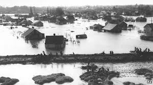
Sirajganj district lies on the bank of the most treacherous river Jamuna. The monsoon spillage of Jamuna is so high that it regularly overflows the banks and creates flooding in most of the upazilas of Sirajganj district. It is an area of perennial floods and its image is that of an area which is always flooded. Every part of the district is not equally vulnerable to flood. Some upazilas are more vulnerable than other due to their location. Chauhali, Kazipur, Sirajganj Sadar, Belkuchi, Ullahpara and Shahjadpur are most flood affected upazilas, of the district because major parts of these upazilas lay in the Jamuna River. These areas are affected by normal and flash flood almost every year. Tarash and Ullahpara upazila is also exposed to flood. Raiganj and Kamarkhanda are comparatively less flood affected upazilas. Severe periodic flooding is also common in the district. Every flood that strikes in Bangladesh affects Sirajganj district. Sirajganj is more or less flooded almost every year, however, severe floods of 1949, 1956, 1961, 1962, 1966, 1968, 1974, 1979, 1987, 1988, 1996, 1998, 2002, 2004, 2007 and 2008 are worth mentioning (NDP, 2007).
Extensive floods greatly affect the marginal population, who lose whatever assets they have and suffer from lack of work and wages. People who live in perennial flood zones in the bank of the Jamuna River have low indicators in all sectors of health, nutrition and education. Floods also contribute to the concentration of landownership due to distress sale by the poor in the post-flood situation to the cash heavy people. However, floods cause serious damage to crops, property, fisheries and livestock and other resources particularly in Sirajganj Table 4.1 shows the information on damage and losses of flood in different years.
Table: Damage and Losses due to Last Four Severe Floods in Sirajganj District
Year | Duration (Days) | Highest Water Level | Affected Area | Affected Population | Death of Causalities Recorded | ||
| Upazila | Union | Family | Population | ||||
1988 | 28 | 15.12 m | 9 | 82 | 268000 | 966000 | 512 |
1998 | 90 | 14.76 m | 9 | 82 | 312595 | 1809968 | 1038 |
2004 | 23 | 14.81 m | 9 | 82 | 430197 | 1915605 | 43 |
2007 | 42 | 14.95 m | 9 | 80 | 229787 | 961314 | 34 |
Source: Sirajganj Zila Parishad, 2012
Factors Responsible to Make Sirajganj Vulnerable to Flood
Sirajganj is the most flood prone district in Bangladesh beside the coastal area. As a large part of the Sirajganj district lies on the Jamuna River, it is frequently affected by flood and river erosion. Most of the nine upazilas almost all are exposed to floods and subsequent river erosion and about 65% people of Sirajganj district are vulnerable to flood. Major part of four upazilas, namely Kazipur, Sirajganj Sadar, Belkuchi and Shahjadpur lie on the Jamuna River and one upazila named Chauhali totally lies in the Jamuna River. About 28 unions out of 82 lie in the river. Tarash and Ullahpara are also vulnerable to flood due to the spilling over of Chalon Beel. So, these factors make the Sirajganj district most vulnerable to flood.
Low topography of Sirajganj is responsible for increasing the duration of flood than other areas of Bangladesh. Rain water flows from up land areas and remains stagnant in Sirajganj and its surrounding areas due to this low topography. Siltation of local rivers, block up canals and land development by filling up water bodies are responsible for water stagnancy in the areas. These factors along with monsoon rainfall increase the duration of flood in Sirajganj in most cases.
Causes of Flood in Sirajganj District
Sirajganj district is mostly affected by the normal (rainfall) and even flash flood. This area is also affected by manmade flood, such as breaching of embankment. The main causes of flood at Sirajganj district including its upazilas:
- Geographical Location and Topographic Climatic Condition
The unique natural setting of Bangladesh and the characteristics of tropical monsoon climate in South Asia are greatly responsible for the flood hazards in the country. In this consequence, the low topographic area of the country like Sirajganj becomes one of the most flood prone areas of the country. High rainfall in India and Nepal during monsoon and snow melting of the Himalayas in the summer causes excessive discharge in the Jamuna River and flood occurs in the adjacent upazilas of Sirajganj district when extra load cannot be carried by the Jamuna River.
- Over Rainfall in the Northern Part of the Country in the Month of June – September
High rainfall occurs during monsoon (June to September) in the northern part of the country, especially in Rangpur and Dinajpur districts, which are also responsible for flood in Sirajganj. The large rainfall run-off coincides with the heavy discharge in the river and causes typical flood.
- Over Spilling of the Jamuna River
Simultaneous heavy discharge of upland stream, high water in estuaries, low topography of the district and river bed siltation account for the bank spilling of the Jamuna River. Another cause of over spilling is the low height of the flood protection embankment on the bank of the Jamuna River. Over spilling of the river causes flash flood in Chauhali, Kazipur, Sirajganj Sadar, Belkuchi and Shahjadpur upazila of the district.
- Breaching and Lack of Flood Protection Embankment
There are some faults in’ the Sirajganj town and district protection embankment. There are breaching, low height, temporary construction etc. These faults allow flood water to inner part of the embankment and cause flood in the district, especially in the Kazipur and Sirajganj Sadar Upazila.
Besides the above, the lack of flood protection embankment is another cause of flood in Sirajganj. According to BWDB’, in the year 2007, 3.5 km and 1.5 km area along the bank of the Jamuna River in the Sirajganj Sadar and Kazipur upazila respectively were not under the coverage of flood protection embankment, which was one of the major causes of the devastating flood of 2007 in these upazilas.
- River Erosion, which Erodes Temporary Flood Protection Embankment
Erosion of the Jamuna River is another reason for flood in Sirajganj district. Every year, the river bank of the Jamuna River erodes the temporarily constructed flood protection embankment (earthen embankment). As a result, the water of the Jamuna River enters into the district during the rainy season and causes enormous flood in the district every year.
- Effect of Chalon Beel
Tarash and Ullahpara upazilas are flooded due to the over spilling of Chalon Beel in the monsoon.
- Siltation of the Local Rivers
There are some rivers within the district such as Ichamoti, Baranai, Durgadaha, Korotoa and Chara Sagar. Siltation in those small rivers hampers the surface runoff or natural flow of rain water towards the Jamuna River and causes water logging and thus flood.
- Soil erosion
Ploughing makes the land surface more susceptible to soil erosion. Surface run-off can easily wash away the topsoil from cultivated lands. This surface erosion reduces land elevations, which in turn increase flood intensity in an area. According to the Report of the Task Forces (RTF) on Bangladesh Development Strategies for the 1990s soil erosion is a serious problem in many parts of Bangladesh. Heavy monsoon shower removes the surface soil through runoff. Parts of eroded sediments are deposited on the riverbeds, reducing the water carrying capacity and increasing flooding propensity in a watershed. Soil erosion also reduces land elevations and increases elevations of riverbeds, contributing to increased flood depths. Moreover, construction sites in cities can contribute to soil erosion if silt fences or retention ponds are not employed properly.
- Lack of Sluice Gates and Drainage Facilities
Lack of appropriately built sluice gates and proper drainage facilities are also responsible for flood in the district. These hamper the flow of rain and surface runoff to the local rivers and cause flood.
- Unplanned road construction
Meghna, Jamuna, Madhumati, Bhairab, Chitra, Gorai etc. road construction. The road network around Bangladesh has also a lot to blame for our flooding problems. We can see that in the last few decades the road network had increased hugely around Bangladesh, but the government has gone about building roads without any planning, study and research. The result is that there is little or no drainage around for the roads built around the country. So floodwater cannot be drained out extensive new roads network.
Condition of Sirajgonj District due to Flood in 2007, 2010 and 2010
Flood of 2007
One of the most recent flood that occurred in Sirajganj district in 2007 is one of the most severe floods that caused in Sirajganj district in recent time.This flood caused huge damage of lives and properties in this area. 58,730 peoples were affected by this flood in Sirajganj district. In the year 2007, flood started in mid july (around 20th) and within a couple of Days, it sub-merged most of the landscape of all the 9 upazilas in Sirajganj district.The water crossed the Danger level (13.75m) at Sirajganj point on 25th july and was recorded to be 14.95 m, in the highest level of on 1st August, in the morning and remain unchanged for about 12 hours.Towards the end of August Sirajganj disrict is effected by flood for the second time in the same year. At that time, all the nine upazilas and five Pourashavas was inundated (NDP, 2007). Many important flood protection infrastructure damages in Flood. Khokshabari flood protection embankment; Bramaputra Right embankment, River bank protection embankment; Nailchapari to Bhanga orad.
Flood of 2008
In 2008 flood also occurs seriously. Most of the people thought that there will not be major flood in this year. Unfortunately from the 19th of August 2008 the river water in the different points started to increase and on 21st August the water crossed danger level. Though the water level decreased again but due to heavy rainpour the water started to increase again and crosses the danger level on 29th July. The water level was flowing 42 cm above the danger level. A major part of the 9 Upazilas in the district started to inundate and people marooned. The flood water stated to engulf and destroy fields after fields. As a result crops have been destroyed. Many homes have gone under water, which damaged the houses of the poor people. The water level of river Jamuna in Sirajgonj point blows above 28 cm of danger level on 1st September. The water level has increased every where in Bramapurra, Tista and Jamuna as India has opened its Tista Dam. The flood water extend level was 104628 hetare or 43%. Due to the increase of flood level more and more villages has been flooded, more houses have gone under water, more crops have been damaged and sufferings of the people increased.Many places erosion turned serious; so far 1,535 families have been eroded.
Flood of 2010
On August 30 the water in the Jamuna was flowing 2cm above at Sirajganj. On September 21, 2010 The Jamuna was flowing 39 centimeters (cm) above the danger level at Sirajganj point. Aman paddy on 6,000 hectares has been submerged and over 11,000 houses have been damaged due to the flood while 15-20 percent of the inundated crop damaged later of Sadar, Kazipur, Belkuchi, Shahjadpur and Chowhali upazila has been submerged by the flood. The water level at the Jamuna bridge in Sirajganj from April 27 to May 9 hit 10.9 metres, compared to 7.5 metres in 2009, 8.1 metres in 2008 and 9.3 metres in 2007.More than 16000 thousand families have been affected at the time of this flood. Several points of the flood control embankment were vulnerable to erosion by the river Jamuna specially Ranigram-Khokshabari embankment. Scarcity of pure drinking water has become acute in flood-affected areas as the tube-wells have been submerged. Educational institutes in the shoal areas along Jamuna basin have been closed. Many of the school buildings on high land are now being used as flood shelters. But not only villages but some of the public flood shelters built to help people affecting by flooding.
Flood in Khorda Gajail Mouza
Khorda Gajail mouza lies on the floodplain of the most treacherous river Jamuna. The monsoon spillage of Jamuna is so high that it regularly overflows the banks and creates flooding in most of the upazilas of Sirajganj district. It is an area of perennial floods and its image is that of an area which is always flooded. Every part of the mouza is not equally vulnerable to flood. But most of the part is under high risk area and rest other parts are in medium risk and low risk area. The mouza is mainly situated on the border of Udhunia union of Ullahpara upazila. On the north side there have Baral and Gumnai river flowing over Bhangura district and on the south side Bil Surujia and Korotoa river are situated. In this area there have two big canals and much small water bodise. So this area is inundated by the influence of those rivers. There have no flood protection embankment on the river bank which parts of the rivers are very close to this mouza. Water mainly come to this two canal and flooded the area. Tarash district is in the north side of the mouza. So, this area is also greatly affected by the Chalaon beel. These areas are affected by normal and flash flood almost every year. Severe periodic flooding is also common in the district. Every flood that strikes in Bangladesh affects Khorda Gajail mouza.
Table : Seasonal Flood calendar Of Khorda Gajail mouza
| Seasonal Flood Calendar of Khorda Gajail Mouza | ||||||||||||
| Disaster | Jan. | Feb. | Mar. | Apr. | May | Jun. | Jul. | Aug. | Sep. | Oct. | Nov. | Dec. |
| Flood | ||||||||||||
High | Medium |
Low | |
Flood in Rajbari District (Focusing Rajbari Sadar Upazila)
Rajbari district lies on the bank of the river Padma. The monsoon spillage of Padma is so high that it regularly overflows the banks and creates flooding in most of the upazilas of Rajbari district. It is an area of perennial floods and its image is that of an area which is always flooded. Every part of the district is not equally vulnerable to flood. Some upazilas are more vulnerable than other due to their location. Goalanda, Baliakandi Rajbari Sadar are most flood affected upazilas, of the district because major parts of these upazilas lay in the Padma River. These areas are affected by normal and flash flood almost every year. Panghsa and Kalukhali upazila is also exposed to flood and Kamarkhanda are comparatively less flood affected upazilas. Severe periodic flooding is also common in the district. Every flood that strikes in Bangladesh affects Rajbari district. Rabarij is more or less flooded almost every year, however, severe floods of 1949, 1956, 1961, 1962, 1966, 1968, 1974, 1979, 1987, 1988, 1996, 1998, 2002, 2004, 2007 and 2008 are worth mentioning (NDP, 2007).
Causes of Flood in Rajbari District
Rajbari district is mostly affected by the normal (rainfall) and even flash flood. This area is also affected by manmade flood, such as breaching of embankment. The main causes of flood at Rajbari district including its upazilas:
- Geographical Location and Topographic Climatic Condition
The unique natural setting of Bangladesh and the characteristics of tropical monsoon climate in South Asia are greatly responsible for the flood hazards in the country. In this consequence, the low topographic area of the country like Rajbari becomes one of the most flood prone areas of the country.
- Over Rainfall in the Month of June – September
High rainfall occurs during monsoon season (June to September) which is also responsible for flood in Rajbari. The large rainfall run-off coincides with the heavy discharge in the river and causes typical flood.
- Over Spilling of the Padma River
Simultaneous heavy discharge of upland stream, high water in estuaries, low topography of the district and river bed siltation account for the bank spilling of the Padma river. Another cause of over spilling is the low height of the flood protection embankment on the bank of the Padma river. Over spilling of the river causes flash flood in Rajbari Sadar, Goalondo and Baliakandi upazila of the district.
- Riverbed Aggradations
Riverbed aggradations are one of the basic cause floods in Bangladesh..In the recent years riverbed has aggraded as much as 5 to 7 meters in the most of big rivers. Riverbed aggradation is most pronounced for the Ganges and its distributaries. The average width of the Padma has decreased from 1.27 to 1.01 km in the years of 1973 to 1985 (Kalam & Jabbar). Riverbed aggradations are serious problem for Bangladesh. For example: The Old Bhamaputra River was navigable for 30 years ago. Now it is an abandoned channel. This situation is true for other rivers of Bangladesh, such as the Padma.
- Breaching and Lack of Flood Protection Embankment
There are some faults in the Rajbari town and district protection embankment. There are breaching, low height, temporary construction etc. These faults allow flood water to inner part of the embankment and cause flood in the district, especially in the Goalonda and Rajbari Sadar Upazila. Besides this which areas are outside of flood protection embankment are most vulnerable.
- River Erosion, which Erodes Temporary Flood Protection Embankment
Erosion of the Padma River is another reason for flood in Rajbari district. Every year, the river bank of the Padma River erodes the temporarily constructed flood protection embankment. As a result, the water of the Padma River enters into the district during the rainy season and causes enormous flood in the district every year.
- Siltation of the Local Rivers
There are some rivers and canals within the district such as Padma, Hori, Chandona & Gorai. Siltation in those small rivers hampers the surface runoff or natural flow of rain water towards the Padma River and causes water logging and thus flood. Much of the Ganges has been diverted for irrigation purposes, this removes some of the silt and prevents the floodplain further downstream from being built up.
- Lack of Sluice Gates and Drainage Facilities
Lack of appropriately built sluice gates and proper drainage facilities are also responsible for flood in the district. These hamper the flow of rain and surface runoff to the local rivers and cause flood.
Condition of Rajbari District due to Flood in 2007, 2008 and 2010
Flood of 2007
The flood of 2207 was one of the most severe flood in the history of Bangladesh. Some areas of Rajbari district were greatly affected by this. The 2007 floods came in two waves. The first wave commenced around the 24th July 2007 and initially affected Nilphamari, Lalmonirhat and Kurigram, Sherpur, Jamalpur, Sylhet, Sunamgonj districts. In following days Rangpur Gaibandha, Bogra, Sirajgonj,Rajbari were flooded, and subsequently the other districts were inundated up until about the 6th August. This represented about 39 districts. The second wave commenced on the 5th September and continued up until the 15th September 2007 when some new districts apart from the previous 39 were flooded. A total of 46 districts were affected to varying degrees during both flood waves. Flood began since July 20, 2007 and most rivers including the Brahmaputra-Jamuna and Ganges-Padma were flowing. On 9 Aug 2007 Rajbari 27% of the total areas severely affected by the flood where 59% of the population affected respectively. The overall situation in Rajbari remains unchanged although water is slowly receding. Water flowing above the danger level and it was 85 cm.
Flood of 2008
Flood of 2008 was not more disastrous as the flood of 2007. Different parts of Rajbari district were flooded. On September 03, 2008 in Goalanda (Rajbari), the River Padma was flowing around 85 cms above danger level at Goalanda point, aggravating flood situation. Around 50,000 people have been marooned in the Upazila due to rise of water level. Crops on 1,480 hectares were damaged by the annual menace. On sptember 9, 2008 Rajbari flood water extent was 14% or 16,273 hectare. Due to the increase of flood level more and more villages has been flooded, more houses have gone under water, more crops have been damaged and sufferings of the people increased. On Aug. 26 erosion by different rivers has taken serious turn in Rajbari. In many places erosion turned very serious and more than 1003 families are faced threat of erosion. Continuous decreasing flood situation rendered several hundred families homeless. The homeless people have taken shelter at embankment and roads and passing their days under the open sky.
Flood of 2010
According to the Flood situation report the flash flood caused by the incessant rains occurred during the last one month since from August 18. On August 30 the Padma 3was flowing 31cm both at Goalunda and Bhagyakul points. On September 21, 2010 the Padma was flowing 60cm above the danger level at Goalundo points of Rajbari district respectively. Aman paddy on 530 hectares of lands has been flooded.
Flood in Bil Nuruddinpur mouza
Bil Nuruddinpur mouza lies on the floodplain one of the major river of Bangladesh river Padma. The monsoon spillage of Padma is so high that it regularly overflows the banks and creates flooding in most of the upazilas of Rajbari district. It is an area of perennial floods and its image is that of an area which is always flooded. Every part of the mouza is not equally vulnerable to flood. But most of the part is under high risk area and rest other parts are in medium risk and low risk area. The mouza is mainly situated on the border of Khanganj union. On the north side of the mouza Padma river is situated and the river is very close to the mouza. A small canal name “Kol of Padma” is flowing in middle of the village. So the water comes to the canal at the time of flood very quickly by inundating half of the mouza so quickly. This mouza is situated outside the flood protection embankment of Rajbari Sadar Upazila. There is a ring embankment inside the mouza. But ewhen flood water increase a little, it cross this embankment area. For situating on the bank of the Padma it is mainly very low lying area. So this area is inundated by the influence of the river. These areas are affected by normal and flash flood almost every year. Severe periodic flooding is also common in the district. Every flood that strikes in Bangladesh affects this mouza. Bil Nuruddinpur is more or less flooded almost every year, however, severe floods of 1949, 1956, 1961, 1962, 1966, 1968, 1974, 1979, 1987, 1988, 1996, 1998, 2002, 2004, 2007, 2008 and 2010 are worth mentioning.
Effects of Flood in Sirajganj and Rajbari District
Effects of flood at Sirajganj and Rajbari district including its upazilas can be classified into two categories, such as:
(1) Positive Effects and
(2) Negative Effects
(1) Positive Effects: The annual flooding of the Jamuna and Padma rivers and other local rivers in Sirajganj and Rajbari district is a blessing, because it makes the land fertile, which helps to increase the agricultural crop production of this area. This is the only commonly believed positive effect of flood in Sirajganj and Rajbari district.
(2) Negative Effects: Flood causes several negative impacts in Sirajganj and Rajbari district. The major negative impacts of flood in Sirajganj and Rajbari district are as follows:
- River erosion and flow of flood water erode houses, land and other assets and people thus loses their valuable assets
- Death and injury of people
- Damages occur in standing crops, seed beds, fisheries and livestock
- Communication system becomes disrupted
- Waterborne diseases spread rapidly
- Water-logging increases in low lands
- Poor people loses their employment
- People forced to be migrated