Introduction
Natural Hazard any natural event which has an adverse socio-economic impact on the human being. Alternatively, an extreme natural event, such as a cyclone, an earthquake or a flood, that is not caused by human beings. These are naturally occurring phenomena that only become hazardous due to the intervention of human infrastructure. The vulnerability of human infrastructure to destruction (risk) by a disaster is also an important factor in understanding natural hazards. The distribution and impact of natural hazards is unequal with greatest loss of life and property in the developing part of the world. This is not because of greater hazard frequency but simply because of greater vulnerability.
Therefore, the people in the developing countries are at high risk than those of developed countries. Combining the risk factor the natural hazard can be defined as the probability of a change in the natural environment of a given magnitude occurring within specified time period in a given area while the associated risk is the consequent damage or loss of life, property and services. The frequency of major hazard appears to have increased since 1960 and the number of people killed each year has decreased at a rate of about 6% and the loss or property has also decreased steadily. This has taken place owing to increased awareness and better hazard management. The increase in the frequency of hazard can be assigned to such factors as better global news coverage, increasing population, increasing urbanization and increasing natural degradation. Natural hazards are now being considered as of global importance and global efforts are being made to mitigate them.
Major Hydrological & Atmospheric disaster in Bangladesh over 200 years
The geographical location, land characteristics, multiplicity of rivers and the monsoon climate render Bangladesh highly vulnerable to natural hazards. The coastal morphology of Bangladesh influences the impact of natural hazards on the area. Especially in the south western area, natural hazards increase the vulnerability of the coastal dwellers and slow down the process of social and economic development. Significant country features include:
• A vast network of rivers and channels
• An enormous discharge of water heavily laden with sediments
• A large number of islands in between the channels
• A shallow northern Bay of Bengal and funneling to the coastal area of Bangladesh
• Strong tidal and wind action
Natural and human induced hazards such as floods, cyclones, droughts, tidal surges, tornadoes, earthquakes, river erosion, fire, infrastructure collapse, high arsenic contents of ground water, water logging, water and soil salinity, epidemic, and various forms of pollution are frequent occurrences.
Flood
Flood relatively high flow of water that overtops the natural or artificial banks in any of the reaches of a stream. When banks are overtopped, water spreads over the floodplain and generally causes problems for inhabitants, crops and vegetation. Since floodplain is a desirable location for man and his activities, it is important to control floods so that the damage does not exceed an acceptable level. In Bangladesh, the definition of flood appears differently. During the rainy season when the water flow exceeds the holding capacity of rivers, canals (khals), beels, haors, low-lying areas it inundates the whole area causing damage to crops, homesteads, roads and other properties. In the Bangladesh context there is a relation between inundation and cropping.
Floods in Bangladesh can be divided into three categories:
- Monsoon flood seasonal, increases slowly and decreases slowly, inundates vast areas and causes huge losses to life and property;
- Flash flood water increases and decreases suddenly, generally happens in the valleys of the hilly areas; and
- Tidal flood short duration, height is generally 3m to 6m, blocks inland flood drainage.
The factors for causing floods in Bangladesh are:
- General low topography of the country with major rivers draining through Bangladesh including a congested river network system,
- Rainfall in the upstream country or in the mainland,
- Snow-melt in the himalayas and glacial displacement (natural),
- River siltation/lateral river contraction/landslides,
- Synchronization of major river peaks and influences of one river on the other,
- Human intervention of the environment,
- Tidal and wind effects on slowing down the river outflow (backwater effect),
- Construction of barrages and protective works along the banks of the river – some are very close to both the banks – in the upper reaches thus making the passage of water flow downstream increasingly narrower and resulting in greater acceleration of water flow downstream presently than before.
- Deforestation in the upper reaches of the rivers is not only leading acceleration of water flow downstream but also lead deposition of loads in the river beds, resulting in reduced channel flow and consequent overland runoff water and
- Tectonic anomalies (earthquake) those change in river flow/morphology.
 Flood history
In the 19th century, six major floods were recorded in 1842, 1858, 1871, 1875, 1885 and 1892. Eighteen major floods occurred in the 20th century. Those of 1987, 1988 and 1951 were of catastrophic consequence. More recent floods include 2004 and 2010.
 Chronology of big floods
| 1781 | Serious flood, which was more pronounced in the western part of sylhet district. The cattle suffered much from the loss of fodder. |
| 1786 | Floods in the Meghna wrought havoc to the crops and immense destruction of the villages on the banks. It was followed by a famine, which caused great loss of life at bakerganj. At Tippera the embankment along the gumti gave way. At Sylhet the parganas were entirely under water, the greater part of the cattle drowned and those surviving were kept on bamboo rafts. |
| 1794 | The Gumti embankment burst again, causing much damage around Tippera. |
| 1822 | Bakerganj division and Patuakhali subdivision were seriously affected, 39,940 people died and 19,000 cattle perished and properties worth more than 130 million taka were destroyed. barisal, Bhola and manpura were severely affected. |
| 1825 | Destructive floods occurred at Bakerganj and adjoining regions. There were no important embankments or other protective works against inundation in the district. |
| 1838 | Heavy rainfall caused extensive inundation at rajshahi and a number of other districts. The cattle suffered much from loss of fodder and the people were greatly inconvenienced when driven to seek shelter on high places and when the water subsided cholera broke out in an epidemic form. |
| 1853 | Annual inundation was more pronounced than usual in the west of Sylhet district, partly the result of very heavy local rainfall and partly caused by the overflow of the Meghna. |
| 1864 | Serious inundation when the embankment was breached and the water of the Ganges flooded the greater part of Rajshahi town. There was much suffering among the people who took shelter with their cattle on the embankment. |
| 1865 | Extensive inundation caused by the annual rising of the Ganges flooded Rajshahi district. Excessive rainfall seriously affected Rajshahi town. |
| 1867 | Destructive flood also affected Bakerganj. Crop was partially destroyed. But no general distress resulted. |
| 1871 | Extensive inundation in Rajshahi and a few other districts. Crops, cattle and valuable properties were damaged. This was the highest flood on record in the district. Cholera broke out in an epidemic form. |
| 1876 | Barisal and patuakhali were severely affected. Meghna overflowed by about 6.71m from the sea level. Galachipa and Bauphal were damaged seriously. A total of about 215,000 people died. Cholera broke out immediately after flood. |
| 1879 | Flooding of the Tista when the change in the course of the Brahmaputra began. |
| 1885 | Serious floods occurred due to the bursting of an embankment along the Bhagirathi, affected areas of Satkhira subdivision of khulna district. |
| 1890 | Serious flood at satkhira caused enormous damage to cattle and people. |
| 1900 | Due to the bursting of an embankment along the Bhagirathi, Satkhira was affected. |
| 1902 | At Sylhet the general level of the river went so high that there was terrible flood. Crops and valuable properties were damaged. |
| 1904 | The crops in some parts of cox’s bazar subdivision and kutubdia island were damaged due to an abnormally high tide. |
| This flood was exceptional in severity in mymensingh. The distress caused on this occasion is probably the nearest parallel to that which resulted from the flooding of the Tista in 1879, when the change in the course of Brahmaputra began. | |
| 1954 | On August 2, Dhaka district went under water. On August 1 flood peak of the jamuna river at Sirajganj was 14.22m and on August 30 flood peak of the Ganges river at hardinge bridge was 14.91m. |
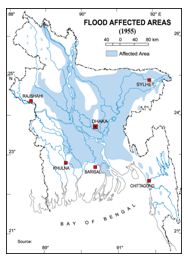
| 1955 | More than 30% of Dhaka district was flooded. The flood level of the buriganga exceeded the highest level of 1954. |
| 1962 | The flood occurred twice, once in July and again in August and September. Many people were affected and crops and valuable properties were damaged. |
| 1966 | One of the most serious floods that ever visited Dhaka occurred on 8 June 1966. The flood level was almost the highest in the history of Sylhet district too. A storm on the morning of 12 June 1966 made the situation grave. About 25% of houses were badly damaged, 39 people died and 10,000 cattle were lost, and about 1,200,000 people were affected. On September 15 Dhaka city became stagnant due to continuous rainfall for 52 hours, which resulted in pools of water 1.83m deep for about 12 hours. |
| 1968 | Severe flood in Sylhet district and about 700,000 people were badly affected. |
| 1969 | Chittagong district fell in the grip of flood caused by heavy rainfall. Crops and valuable property were damaged |
| 1974 | In Mymensingh about 10,360 sq km area was flooded. People and cattle were severely affected and more than 100,000 houses were destroyed. |
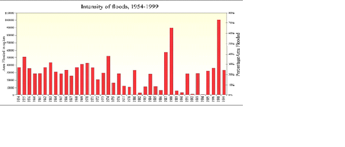
| 1987 | Catastrophic flood occurred in July-August. Affected 57,300 sq km (about 40% of the total area of the country) and estimated to be a once in 30-70 year event. Excessive rainfall both inside and outside of the country was the main cause of the flood. The seriously affected regions were on the western side of the Brahmaputra, the area below the confluence of the Ganges and the Brahmaputra, considerable areas north of Khulna and finally some areas adjacent to the Meghalaya hills. |
| 1988 | Catastrophic flood occurred in August-September. Inundated about 82,000 sq km (about 60% of the area) and its return period is estimated to be 50-100 years. Rainfall together with synchronization of very high flows of all the three major rivers of the country in only three days aggravated the flood. Dhaka, the capital of Bangladesh, was severely affected. The flood lasted 15 to 20 days. |
| 1989 | Flooded Sylhet, sirajganj and maulvi bazar and 600,000 people were trapped by water. |
| 1993 | Severe rains all over the country, thousands of hectares of crops went under water. Twenty-eight districts were flooded. |
| 1998 | Over two-thirds of the total area of the country was flooded. It compares with the catastrophic flood of 1988 so far as the extent of flooding is concerned. A combination of heavy rainfall within and outside the country, synchronizations of peak flows of the major rivers and a very strong backwater effect coalesced into a mix that resulted in the worst flood in recorded history. The flood lasted for more than two months. |
| 2000 | Five southwestern districts of Bangladesh bordering India were devastated by flood rendering nearly 3 million people homeless. The flood was caused due to the outcome of the failure of small river dykes in West Bengal that were overtopped by excessive water collected through heavy downpour. |
 Cyclones and Storm Surges
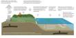
Typhoons are tropical revolving storms. They are called `Cyclones’ in English, when they occur in the Indian Ocean area. The coastal regions of Bangladesh are subject to damaging cyclones almost every year. They generally occur in early summer (April-May) or late rainy season (October-November). Cyclones originate from low atmospheric pressures over the Bay of Bengal. Flowing Figure shows a typical cyclone structure formed in the tropics of the northern hemisphere.
Cyclones in the Bay of Bengal Because of the funnel shaped coast of the Bay of Bengal, Bangladesh very often becomes the landing ground of cyclones formed in the Bay of Bengal. The Bay cyclones also move towards the eastern coast of India, towards Myanmar and occasionally into Sri Lanka. But they cause the maximum damage when they come into Bangladesh, west bengal and Orissa of India. This is because of the low flat terrain, high density of population and poorly built houses. Most of the damage occur in the coastal regions of Khulna, Patuakhali, Barisal, Noakhali and Chittagong and the offshore islands of Bhola, Hatiya, Sandwip, Manpura, Kutubdia, Maheshkhali, Nijhum Dwip, Urir Char and other newly formed islands.
From 1981 to 1985, 174 severe cyclones (with wind speeds of more than 54 km/hr) formed in the Bay of Bengal. The month-wise occurrence is as follows: 1 in January, 1 in February, 1 in March, 9 in April, 32 in May, 6 in June, 8 in July, 4 in August, 14 in September, 31 in October, 47 in November and 20 in December. It is apparent from the above figures that severe cyclones occur mostly during pre-monsoon (April-May) and post-monsoon (September-December) periods and they are the ones which cause the most destruction.
Chronology of major cyclonic storms
Bakerganj (presently Barisal) and Patuakhali; hurricane with thunder and lightening continued for five hours; the houses and boats were swallowed up, leaving only Hindu temples on a height; about 2,000,000 living creatures perished. Mouth of the Meghna estuary; severe storm wave swept up the eastern side of Bakerganj; number of living creatures perished, standing crops destroyed. Chittagong; severe cyclonic storm; every hut levelled to the ground and 2 vessels sunk in chittagong port. Barisal, Hatiya Island and Noakhali district; severe cyclonic storm with storm wave; Collectorate records swept away, 40,000 people killed and 100,000 cattle lost. Barisal; storm-wave; many lives lost and cattle destroyed. cyclonic storm; exact figures of the loss of lives and cattle are not available. Meghna estuary and coasts of Chittagong, Barisal, Noakhali; most severe storm-surge of about 12.2m (40 ft) height; about 200,000 people died during the storm, but perhaps more people died from the after-effects of the storm, such as epidemic and famine, and enormous properties destroyed by tidal bore. Considering the population at that time, a death figure of 200,000 was indeed too heavy. Chittagong; hurricane reached maximum intensity with series of storm-waves; Kutubdia Island and coastal villages were swept over, 14,000 people killed and 18,000 died in epidemics (cholera) that followed. Teknaf; cyclonic storm-waves; exact figures of damage not available. Sonadia; cyclonic storm; 143 killed and fishing fleet wrecked. cyclonic storm-waves; killed 698 people and 70,654 cattle. cyclonic storm; demolished many villages killing about 500 persons. hurricane; 432 persons killed and 28,029 cattle lost. cyclonic storm with storm-wave; exact figures of the loss of lives and cattle are not available. severe cyclonic storm; number of human lives, exact figures of the loss of wildlife and boats are not available. cyclonic storm; about 1,200 persons killed and 20,000 cattle lost. cyclonic storm along with surge; 870 persons killed, 14,500 cattle lost and standing crops destroyed. cyclonic storm; about 100,000 families lost their homes and government had to provide house-building loans. Eastern Meghna estuary (Noakhali, Bakerganj, Faridpur and Patuakhali); severe cyclonic storm, maximum wind speed 201 km/hr, maximum storm wave 3.05m; considerable damage to Char Jabbar, Char Amina, Char Bhatia, Ramgati, Hatiya and Noakhali; 3,000 lives lost, 62,725 houses damaged, crops on 94,000 acres of land were fully damaged and thousands of cattle perished Bagerhat and Khulna; severe cyclonic storm with a wind speed of 161 km/hr, surge 2.44-3.05m; rail track between Noakhali and Harinarayanpur damaged, heavy loss of life in Char Alexander, 11,468 people killed and about 25,000 cattle head destroyed. Feni; severe cyclonic storm with a wind speed of 161 km/hr, surge 2.5-3.0m; heavy loss of life; about 1,000 people died and many domestic cattle perished.Chittagong, Noakhali, Cox’s Bazar and the offshore islands of Sandwip, Kutubdia, Hatiya and Maheshkhali were badly affected; severe cyclonic storm with storm-wave rising 4.3-5.2m in Chittagong, maximum wind speed 203 km/hr and at Cox’s Bazar 164 km/hr; more than 11,520 people killed, 32,617 cattle lost, 376,332 houses, 4,787 boats and standing crops destroyed.Barisal and Bakerganj; most severe cyclonic storm, maximum speed 162 km/hr with storm-wave rising 3.7m; total loss of life 19,279; in Barisal alone 16,456 people killed. Cox’s Bazar along with adjacent coastal area and Patuakhali; severe cyclonic storm with storm-wave rising 4.7-6.1m; maximum speed 210 km/hr in Cox’s Bazar, hoisted danger signal #10 at Cox’s Bazar and along the coast of Sonadia, Rangadia and Hamidia islands, and Patuakhali; 40,000 salt beds in Cox’s Bazar inundated and 873 people killed. Sandwip, Bakerganj, Khulna, Chittagong, Noakhali and Comilla; severe cyclonic storm with storm-waves of 4.7-9.1m, maximum wind speed 146 km/hr; affected 1.5 million people, loss of human life and livestock were 850 and 65,000 respectively in Noakhali and Bakerganj. Demra (Dhaka district); tornado locally known as Kalbaishakhi with wind speed of 643 km/hr; 922 people killed and 16,511 injured; estimated loss Tk 40 to 50 million. The most deadly and devastating cyclonic storm that caused the highest casualty in the history of Bangladesh. Chittagong was battered by hurricane winds. It also hit Barguna, Khepupara, Patuakhali, and north of Char Burhanuddin, Char Tazumuddin and south of Maijdi, Haringhata and caused heavy loss of lives and damage to crops and property. Officially the death figure was put at 500,000 but it could be more. A total of 38,000 marine and 77,000 inland fishermen were affected by the cyclone. It was estimated that some 46,000 inland fishermen operating in the cyclone affected region lost their lives. More than 20,000 fishing boats were destroyed; the damage to property and crops was colossal. Over one million cattle head were reported lost. More than 400,000 houses and 3,500 educational institutions were damaged. The maximum recorded wind speed of the 1970 cyclone was about 222 km/hr and the maximum storm surge height was about 10.6m and the cyclone occurred during high-tide. Chittagong coast; severe cyclonic storm; exact figures of the loss of lives and cattle are not available. Sundarban coast; cyclonic storm with a wind speed of 97-113 km/hr and storm surge of less than 1m; Khulna district experienced stormy weather and low lying areas of Khulna town inundated. Sundarban coast; severe cyclonic storm accompanied by storm surge; low-lying coastal areas of Patuakhali and adjoining offshore islands inundated. Khulna; cyclonic storm with a wind speed of 80.5 km/hr; about 600 lives lost and number of cattle head destroyed. Coastal belt from Cox’s Bazar to Chittagong and offshore islands; severe cyclonic storm with a wind speed of 161 km/hr and storm surge of 2.8-5.2 m; 200 people killed, 1000 cattle lost and 2,300 houses perished. Bhola, Cox’s Bazar and Khulna; severe cyclonic storm with a wind speed of 96.5 to 112.6 km/hr; 5 persons killed and a number of fishermen missing. Khulna, Noakhali, Patuakhali, Barisal, Chittagong and offshore islands; cyclonic storm with a wind speed of 112.63 km/hr; exact figures of the loss of lives and cattle are not available. Offshore islands and chars of Chittagong and Noakhali; severe cyclonic storm with a wind speed of 122 km/hr; 43 persons killed, 6 fishing boats and a trawler lost, more than 150 fishermen and 100 fishing boats missing and 20% aman crops destroyed. Chittagong, Cox’s Bazar coast near Kutubdia and the low lying areas of St Martin’s Island, Teknaf, Ukhia, Moipong, Sonadia, Barisal, Patuakhali and Noakhali; severe cyclonic storm (hurricane) with a wind speed of 136 km/hr and a storm surge of 1.52m height; 300 fishermen with 50 boats missing and 2,000 houses destroyed. Chittagong, Cox’s Bazar, Noakhali and their offshore islands (Sandwip, Hatiya, and Urirchar); severe cyclonic storm, wind speed Chittagong 154 km/hr, Sandwip 140 km/hr, Cox’s Bazar 100 km/hr and storm surge of 3.0-4.6m; about 11,069 persons killed, 94,379 houses damaged, livestock lost 135,033 and road damaged 74 km, embankments damaged. Offshore island and chars of Chittagong, Barisal, Patuakhali and Noakhali; cyclonic storm hit 110 km/hr at Chittagong and 90/hr at Khulna; 14 persons killed, damaged 97,200 ha of paddy fields, damage to schools, mosques, warehouses, hospitals, houses and buildings at Amtali upazila in Barguna. Jessore, Kushtia, Faridpur, offshore islands and chars of Barisal and Khulna; severe cyclonic storm with core wind speed 162 km/hr, storm surge of 4.5m at Mongla point; killed 5,708 persons and lot of wild animals – deer 15,000, Royal Bengal Tiger 9, cattle 65,000 and crops damaged worth about Tk 9.41 billion. The Great Cyclone of 1991, crossed the Bangladesh coast during the night. It originated in the Pacific about 6,000 km away and took 20 days to reach the coast of Bangladesh. It had a dimension of more than the size of Bangladesh. The central overcast cloud had a diameter exceeding 600 km. The maximum wind speed observed at Sandwip was 225 km/hr. The wind speeds recorded at different places were as follows: Chittagong 160 km/hr, Khepupara (Kalapara) 180 km/hr, Kutubdia 180 km/hr, Cox’s Bazar 185 km/hr, and Bhola 178 km/hr. The maximum wind speed estimated from NOAA-11 satellite picture obtained at 13:38 hours on 29 April was about 240 km/hr. The cyclone was detected as a depression (wind speed not exceeding 62 km/hr) on the 23rd April first in the satellite picture taken at SPARRSO from NOAA-11 and GMS-4 satellites. It turned into a cyclonic storm on 25 April. The cyclone in its initial stage moved slightly northwest and then north. From 28 April it started moving in a north-easterly direction and crossed the Bangladesh coast north of Chittagong port during the night of the 29th April. The cyclone started affecting the coastal islands like Nijhum Dwip, Manpura, Bhola and Sandwip from the evening of that day. The maximum storm surge height during this cyclone was estimated to be about 5 to 8m. The loss of life and property was colossal. The loss of property was estimated at about Tk 60 billion. The death toll was estimated at 150,000; cattle head killed 70,000. Offshore islands and chars of Patuakhali, Barisal, Noakhali and Chittagong; cyclonic storm, maximum wind speed 110 km/hr and surge height of 1.9m; people killed, cattle head perished, boats lost and standing crops destroyed. Offshore island and chars of Cox’s Bazar; severe cyclonic storm with maximum wind speed of 210 km/hr; people killed about 400, cattle lost about 8,000. Offshore island and chars of Cox’s Bazar; severe cyclonic storm with maximum wind speed of 210 km/hr; about 650 people killed, 17,000 cattle head perished. Offshore islands and chars of Chittagong, Cox’s Bazar, Noakhali and Bhola; severe cyclonic storm (hurricane) with a wind speed of 225 km/hr, storm surge of 3.05m (similar strength to that of 1970 cyclone); only 126 people killed because of better disaster management measures taken by the government and the people. Offshore islands and chars of Chittagong, Cox’s Bazar, Noakhali and Bhola; severe cyclonic storm (hurricane) with a wind speed of 150 km/hr, storm surge of 1.83 to 3.05m. Offshore islands and chars of Chittagong, Cox’s Bazar and Noakhali; severe cyclonic storm (hurricane) with a wind speed of 150 km/hr, storm surge of 1.83 to 2.44m. Offshore islands and chars of Khulna, Barisal and Patuakhali; cyclonic storm with maximum wind speed of 90 km/hr, storm surge of 1.22 to 2.44m. Cyclone Sidr makes landfall on southern Bangladesh, causing over 2,000 deaths and severe damage.
Tornado
The two transitional periods between southwest and northeast monsoons over the Indian sub-continent are characterized by local severe storms. The transitional periods are usually referred to as pre-monsoon (March-May), and post-monsoon (October- November). It is the pre-monsoon period when most of the abnormal rainfall or drought conditions frequently occur in different parts of Bangladesh. Also there are severe local seasonal storms, popularly known as nor’westers (kalbaishakhi). Severe nor’westers are generally associated with tornadoes. Tornadoes are embedded within a mother thundercloud, and moves along the direction of the squall of the mother storm. The frequency of devastating nor’westers usually
reaches the maximum in April, while a few occur in May, and the minimum in March. Nor’westers and tornadoes are more frequent in the afternoon. Table 3 shows some of the devastating nor’westers and tornadoes that hit Bangladesh. Nor’westers may occur in late February due to early withdrawal of winter from Bangladesh, Bihar, West Bengal, Assam, and adjoining areas. The occasional occurrence of nor’westers in early June is due to the delay in the onset of the southwest monsoon over the region.
List of Tornados in Bangladesh
Date | Location |
| 04-08-1838 | Eastern side of Calcutta, IN |
| 05-01-1865 | Pundooah in Hooghly dist. IN |
| 04-15-1872 | Satkhira in 24-Paraganas dist. IN |
| 03-26-1875 | Uladah, Mymensingh dist. BD |
| 03-31-1875 | Mymensingh dist. BD |
| 03-27-1888 | Jessore dist. Hit 2 miles sse of Magura, BD |
| 03-27-1888 | Pabna dist., BD |
| 04-07-1888 | Dhaka, BD |
| 04-07-1888 | Rajbari, BD |
| 04-27-1888 | 16 miles north of Calcutta, IN |
| 04-29-1895 | Manikganj, BD |
| 04-12-1902 | Dhaka, BD |
| 03-28-1903 | Rangpur, BD |
| 04-29-1904 | Pabna, BD |
| 04-04-1927 | Noakhali, BD |
| 03-20-1951 | DiamondHarbour in Midnapore dist. of West Bengal, IN |
| 05-02-1951 | Gopalganj |
| 05-02-1951 | Narail, BD |
| 05-12-1951 | Faridpur dist., BD |
| 03-13-1953 | Meherpur in Kustia dist., BD |
| 05-05-1954 | Bhairab Bazaar, BD |
| 05-21-1959 | Alipore in the south suburbs of Calcutta, IN |
| 03-18-1961 | along Jamuna river near Mymensingh-Rangpur border, BD |
| 03-19-1961 | Jhaukandi in Faridpur, Dohar and Nawabganj in Dacca dist. BD |
| 04-03-1961 | hit south of Comilla between Zangalia and Lalmia, BD |
| 04-15-1962 | Kalibari and Kishorganj, BD |
| 03-10-1963 | Atpara and Barghata in Mymensingh dist., BD |
| 04-19-1963 | Formed north of Cooch Behar, IN |
| 04-11-1964 | Magura and Narail dists. including Mohammadpur, BD |
| 03-23-1965 | Kustia dist., BD |
| 03-21-1967 | Karimganj, BD |
| 04-16-1967 | Naria and Bhederganj unions, BD |
| 04-17-1967 | Sonamura in Tripura dist., IN |
| 04-19-1967 | Sudharam, BD |
| 05-01-1967 | Laksham in Comilla dist. and Munshiganj in Dhaka dist. BD |
| 04-03-1968 | Noakhali dist. Hit Raipur, Lumxipur & Begumganj, BD |
| 04-11-1968 | Naria, Zajira and Bhederganj under Sariatpur zila, BD |
| 03-21-1969 | DiamondHarbour in Midnapore dist. of West Bengal, IN |
| 04-14-1969 | NE suburbs of Dhaka BD |
| 04-14-1969 | Homna P.S. under Comilla dist. BD |
| 04-17-1969 | Kharmakhali and Khoksa in Kustia dist., BD |
| 04-17-1969 | Rajshahi dist. Moved from Gustompur to Manda unions, BD |
| 04-17-1969 | Tangail and Sirajganj in Mymensingh dist., BD |
| 04-28-1969 | Katiadi in Mymensingh dist., BD |
| 04-13-1970 | Joydepur and Sreepur of Gazipur dist., BD |
| 04-01-1972 | 14 miles southwest of Mymensingh, BD |
| 04-05-1972 | Keraniganj and Baliaghata in south Dhaka suburbs, BD |
| 04-29-1972 | Bhakua and Haripur unions of Barishal P.S., BD |
| 04-12-1973 | Baliakandi in Faridpur dist., BD |
| 04-14-1973 | Alipur Duar subdiv. of Jalpaiguri, WB, IN |
| 04-17-1973 | Manikganj, Singair and Nawabganj in Dhaka dist., BD |
| 04-11-1974 | 11 miles W of Bogra, BD |
| 04-10-1976 | Naria and Bhederganj under Sariatpur zila, BD |
| 05-08-1976 | HatiyaIsland, BD |
| 05-09-1976 | S. suburbs of Dacca, BD |
| 03-31-1977 | Lahund and Dangargaon villages in Katiadi, BD |
| 04-01-1977 | Madaripur & Shibchar, BD |
| 04-02-1977 | Mokshedpur, Bhanga and Tungipara unions of Gopalganj, BD |
| 04-07-1977 | Gholapara and Fakiradanga villages of Nadia dist., IN |
| 04-15-1977 | 13 km north of Contai in Midnapore dist., IN |
| 04-16-1978 | Jaipur and Keonjhar dist. of Orissa, IN |
| 04-18-1978 | Karimpur in Murshidibad of Nadia dist., West Bengal state, IN |
| 05-07-1979 | Jamalpur, BD |
| 03-01-1981 | Itna, BD |
| 04-12-1981 | Parshuram to Fulgazi to Somarpur to Sonagazi in Feni dist., BD |
| 04-17-1981 | Moved along Baitarani river, BD. Hit villages of Kapundi, Erandi, Dhanbeni and Rengalbeda. |
| 04-12-1982 | Rangpur and Gaibandha, BD |
| 04-09-1983 | Jessore, BD |
| 04-12-1983 | 40 km northeast of Calcutta. Galahata under Bangaon, IN |
| 04-23-1983 | Raghunathpur village of Kutubpur union in Fatullah, BD |
| 04-24-1983 | Rupsha under Khulna dist., BD |
| 04-14-1986 | Borni of Tongiapara, BD |
| 04-26-1989 | Daultipur and Salturia, BD |
| 04-28-1989 | Missile launch site, IN |
| 04-20-1990 | Taras, Ullahpara and Shahazadpur in Sirajganj, BD |
| 04-29-1990 | Sirajganj, BD |
| 03-31-1991 | Champak in Comilla, BD |
| 05-07-1991 | Between Tongi, Joydevpur and Gazipur, BD |
| 05-18-1991 | Gournadi in Barisal, BD |
| 04-22-1992 | Naogaon in Assam, IN |
| 04-09-1993 | Kandi, Murshidibad dist., IN |
| 05-13-1993 | Begumganj, Noakhali dist., BD |
| 04-08-1995 | Lohaganj, Serajdikhan and Srinigar in Munshiganj dist., BD |
| 05-13-1996 | Madarganj, Gopalpur, Kallhati, Basail, Shakipur and Mrizapur in Jamalpur and Tangail districts, BD |
| 03-24-1998 | Dantan along border between Orissa and West Bengal, IN |
| 04-08-1998 | Nilphimari, BD |
| 03-26-1999 | Panchagarh distric, BD |
| 09-19-2000 | Savar and Gazipur districts near Dhaka |
| 05-04-2003 | Brahmanbaria |
| 03-21-2005 | Gaibandha |
Wind speeds in nor’westers usually do not exceed 113-130 km/hr (70-80 miles/hr), though often their speeds exceed 162 km/hr (100 miles/hr). When the winds become whirling with funnel shaped clouds having a speed of several hundred kilometers or miles per hour, they are called tornados. Nor’westers brings the much-needed pre-monsoon rain. They can also cause a lot of havoc and destruction. Tornados are suddenly formed and are extremely localized in nature and of brief duration. Thus, it is very difficult to locate them or forecast their occurrence with the techniques available at present. However, highresolution satellite pictures, suitable radar, and a network of densely spaced meteorological observatories could be useful for the prediction or for issuing warnings of nor’westers and tornados.
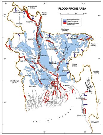
River Bank Erosion
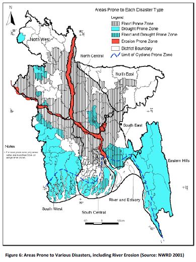
Riverbank Erosion an endemic and recurrent natural hazard in Bangladesh. When rivers enter the mature stage (as in the case with the three mighty rivers, ganges, brahmaputra and meghna) they become sluggish and meander or braid. These oscillations cause massive riverbank erosion. Every year, millions of people are affected by erosion that destroys standing crops, farmland and homestead land. It is estimated that about 5% of the total floodplain of Bangladesh is directly affected by erosion. Some researchers have reported that bank erosion is taking place in about 94 out of 489 upazilas of the country. A few other researchers have identified 56 upazilas with incidence of erosion. At present, bank erosion and flood hazards in nearly 100 upazilas have become almost a regular feature. Of these, 35 are severely affected.
The Jamuna is a braided river with bank materials that are highly susceptible to erosion. Since the Brahmaputra switched to the course of the jamuna at the western side of the madhupur tract, the average width of the river has fluctuated substantially. The recorded minimum average width of the Jamuna was 5.6 km in 1914. Locally, the maximum width has often exceeded 15 km, while the recorded local minimum width was about 1.1km. The rate of widening of the river within the period 1973 to 2000 is 128m/year (68m for the left bank and 60m for the right bank). The annual rate of widening has been as high as 184m during 1984-92, of which 100m occurred along the left and 84m along the right bank (Table 1). In this period, the average width of the river increased from 9.7 to 11.2 km (Table 2). The maximum bank erosion during 1984-92 occurred at the left bank, just upstream of Aricha. Both rotation and extension bank erosion mechanisms do occur.
The Jamuna has persistently widened from 1973 to the early nineties, but the yearly rate seems to have gone down significantly in the late nineties. The widening of the river in a 28-year period resulted in a loss of floodplain of 70,000 ha over the total 220 km length of the river in Bangladesh (average about 2,600 ha/year). Within the 1984-92 period, the river has eroded 40,150 ha of floodplain and accreted 7,140 ha, corresponding to an erosion rate of about 5,000 ha/year, and an accretion rate of about 900 ha/year.
The Padma bank erosion in the padma is governed by the planform characteristics of a wandering river. The braided reach of the river is eroding along both banks, while the meandering reaches erode only the outer banks. The width of the river varied from 3.7 to 8.5 km during 1984 and from 2.7 to 10.7 km during 1993. The narrowest sections of 3.7 and 2.7km remain at Baruria, downstream of the confluence with the Jamuna for the period 1984-93. The average width of the river varied from 5.7 km in 1984 to 7.1 km in 1993, corresponding to a widening rate of 159 m/year; left and right bank erosion rates were 121 m and 38m per year respectably. Though less than what was observed in the case of the Jamuna, the widening of the Padma during the period 1984-93 was quite significant.
The Upper Meghna unlike the other main rivers of Bangladesh, the Upper Meghna is a stable and seemingly inert river. The width of the river varied from 1 km to 11.5 km in 1984, while the range of variation was 1 to 11.3 km in 1993. The high spatial variation of width is due to the presence of a permanent char, with a width of more than 9 km. The average width of the river in 1984 was 3.41 km while in 1993 it was 3.39 km. Average bank erosion rates along the right and left banks of the river were found to be 9m and 7m per year respectively.
The Lower Meghna after the Padma broke through the Chandina alluvium and joined the Meghna at the present confluence about 150 years ago, the Lower Meghna had to adjust to carry the combined discharge of the Jamuna, Ganges and Meghna rivers. The confluence of the Upper Meghna and the Padma can be considered as part of the Lower Meghna. The confluence consists of a wide cluster of chars bounded by two channels. The highest width of the confluence is 14.4 km. Its average width varied from 7.98 in 1984 to 9.01 km in l993, reflecting a widening rate of about 100 m/year.
 Earthquake
Earthquake trembling or shaking movement of the earth’s surface. Most earthquakes are minor tremors, while larger earthquakes usually begin with slight tremors, rapidly take the form of one or more violent shocks, and end in vibrations of gradually diminishing force called aftershocks. Earthquake is a form of energy of wave motion, which originates in a limited region and then spreads out in all directions from the source of disturbance. The most common measure of earthquake size is the Richter’s magnitude (M). The Richter scale uses the maximum surface wave amplitude in the seismogram and the difference in the arrival times of primary (P) and secondary (S) waves for determining magnitude (M). The magnitude is related to roughly logarithm of energy, E in ergs.
Earthquakes originate due to various reasons, which fall into two major categories viz non-tectonic and tectonic. The origin of tectonic earthquakes is explained with the help of ‘elastic rebound theory’. Earthquakes are distributed unevenly on the globe. However, it has been observed that most of the destructive earthquakes originate within two well-defined zones or belts namely, ‘the circum-Pacific belt’ and ‘the Mediterranean-Himalayan seismic belt’.
Although Bangladesh is extremely vulnerable to seismic activity, the nature and the level of this activity is yet to be defined. In Bangladesh complete earthquake monitoring facilities are not available. The Meteorological Department of Bangladesh established a seismic observatory at Chittagong in 1954. This remains the only observatory in the country.
Before the coming of the Europeans, there was no definite record of earthquakes. Following is a chronology of important earthquakes from 1548.
Chronology
1548 | The first recorded earthquake was a terrible one. Sylhet and Chittagong were violently shaken, the earth opened in many places and threw up water and mud of a sulphurous smell. |
1642 | More severe damage occurred in Sylhet district. Buildings were cracked but there was no loss of life. |
1663 | Severe earthquake in assam, which continued for half an hour and Sylhet district was not free from its shock. |
1762 | The great earthquake of April 2, which raised the coast of Foul island by 2.74m and the northwest coast of Chedua island by 6.71m above sea level and also caused a permanent submergence of 155.40 sq km near Chittagong. The earthquake proved very violent in Dhaka and along the eastern bank of the meghna as far as Chittagong. In Dhaka 500 persons lost their lives, the rivers and jheels were agitated and rose high above their usual levels and when they receded their banks were strewn with dead fish. A large river dried up, a tract of land sank and 200 people with all their cattle were lost. Two volcanoes were said to have opened in the Sitakunda hills. |
1775 | Severe earthquake in Dhaka around April 10, but no loss of life. |
1812 | Severe earthquake in many places of Bangladesh around May 11. The earthquake proved violent in Sylhet |
1865 | Terrible shock was felt, during the second earthquake occurred in the winter of 1865, although no serious damage occurred. |
1869 | Known as Cachar Earthquake. Severely felt in Sylhet but no loss of life. The steeple of the church was shattered, the walls of the courthouse and the circuit bungalow cracked and in the eastern part of the district the banks of many rivers caved in. |
1885 | Known as the Bengal Earthquake. Occurred on 14 July with 7.0 magnitude and the epicentre was at Manikganj. This event was generally associated with the deep-seated Jamuna Fault. |
1889 | Occurred on 10 January with 7.5 magnitudes and the epicentre at Jaintia Hills. It affected Sylhet town and surrounding areas. |
1897 | Known as the Great India Earthquake with a magnitude of 8.7 and epicentre at Shillong Plateau. The great earthquake occurred on 12 June at 5.15 pm, caused serious damage to masonry buildings in Sylhet town where the death toll rose to 545. This was due to the collapse of the masonry buildings. The tremor was felt throughout Bengal, from the south Lushai Hills on the east to Shahbad on the west. In Mymensingh, many public buildings of the district town, including the Justice House, were wrecked and very few of the two-storied brick-built houses belonging to zamindars survived. Heavy damage was done to the bridges on the Dhaka-Mymensingh railway and traffic was suspended for about a fortnight. The river communication of the district was seriously affected (brahmaputra). Loss of life was not great, but loss of property was estimated at five million Rupees. Rajshahi suffered severe shocks, especially on the eastern side, and 15 persons died. In Dhaka damage to property was heavy. In Tippera masonry buildings and old temples suffered a lot and the total damage was estimated at Rs 9,000. |
1918 | Known as the Srimangal Earthquake. Occurred on 18 July with a magnitude of 7.6 and epicentre at Srimangal, Maulvi Bazar. Intense damage occurred in Srimangal, but in Dhaka only minor effects were observed. |
1930 | Known as the Dhubri Earthquake. Occurred on 3 July with a magnitude of 7.1 and the epicentre at Dhubri, Assam. The earthquake caused major damage in the eastern parts of Rangpur district. |
1934 | Known as the Bihar-Nepal Earthquake. Occurred on 15 January with a magnitude of 8.3 and the epicentre at Darbhanga of Bihar, India. The earthquake caused great damage in Bihar, Nepal and Uttar Pradesh but did not affect any part of Bangladesh. |
| Another earhquake occured on 3 July with a magnitude of 7.1 and the epicentre at Dhubri of Assam, India. The earthquake caused considerable damages in greater Rangpur district of Bangladesh. | |
1950 | Known as the Assam Earthquake. Occurred on 15 August with a magnitude of 8.4 with the epicentre in Assam, India. The tremor was felt throughout Bangladesh but no damage was reported. |
1997 | Occurred on 22 November in Chittagong with a magnitude of 6.0. It caused minor damage around Chittagong town. |
1999 | Occurred on 22 July at MaheshkhaliIsland with the epicentre in the same place, a magnitude of 5.2. Severely felt around Maheshkhali island and the adjoining sea. Houses cracked and in some cases collapsed. |
2003 | Occurred on 27 July at Kolabunia union of Barkal upazila, Rangamati district with magnitude 5.1. The time was at 05:17:26.8 hours. |
Drought
Drought a prolonged, continuous period of dry weather along with abnormal insufficient rainfall. It occurs when evaporation and transpiration exceed the amount of precipitation for a reasonable period. Drought causes the earth to parch and a considerable hydrologic (water) imbalance resulting water shortages, wells to dry, depletion of groundwater and soil moisture, stream flow reduction, crops to wither leading to crop failure and scarcity in fodder for livestock. Drought is a major natural hazard faced by communities directly dependent on rainfall for drinking water, crop production, and rearing of animals. Since ancient times droughts have far-reaching effects on mankind. Large land areas often suffer damages from dust storms and fire. Drought could be the reason for migration of early human communities. It has long been considered to be a natural hazard responsible for ups and downs of many civilizations of the world. The worst drought of the last century in the sub-continent occurred in 12 states of India in 1999-2000.
In Bangladesh drought is defined as the period when moisture content of soil is less than the required amount for satisfactory crop-growth during the normal crop-growing season. Droughts are common in the northwestern districts of Bangladesh.
Drought mostly affects Bangladesh in pre-monsoon and post-monsoon periods. From 1949 to 1979 drought conditions had never affected the entire country. The percentage of drought affected areas were 31.63% in 1951, 46.54% in 1957, 37.47% in 1958, 22.39% in 1961, 18.42% in 1966, 42.48% in 1972 and 42.04% in 1979. During 1981 and 1982 droughts affected the production of the monsoon crops only. During the last 50 years, Bangladesh suffered about 20 drought conditions. The drought condition in northwestern Bangladesh in recent decades had led to a shortfall of rice production of 3.5 million tons in the 1990s.
Chronology of droughts of historical significance:
1791 | Drought affected Jessore district. Prices had risen to twice and three times of their usual levels. |
1865 | Drought proceeding famine occurred in Dhaka. |
1866 | Severe drought in Bogra. The rice production of the district was hit hard and the price went up three times its normal level. |
1872 | Drought in Sundarbans. The rainfall was deficient and in several lots the crops suffered to a great extent. |
1874 | Bogra was affected and the crop failure was much greater. The rainfall was extremely low. |
1951 | Severe drought in northwest Bangladesh and substantially reduced rice production. |
1973 | One of the severest in the present century and was responsible for the 1974 famine in northern Bangladesh. |
1975 | This drought affected 47% of the entire country and caused sufferings to about 53% of the total population. |
1978-79 | Severe drought causing widespread damage to crops. Reduced rice production by about 2 million tons and directly affected about 42% of the cultivated land and 44% of the population. It was one of the severest in recent times. |
1981 | Severe drought adversely affected crop production. |
1982 | Caused a total loss of rice production amounting to about 53,000 tons. In the same year flood damaged about 36,000 tons of rice. |
1989 | Most of the rivers in NW Bangladesh dried up and several districts, such as Naogaon, Nawabganj, Nilpahamari and Thakurgaon; dust syndrome occurred for a prolonged period due to drying up the topsoil. |
1994-95 | This drought was followed by that of 1995-96, caused immense damage to crops, especially in the case of rice and jute the main crops of NW Bangladesh. These are followed by bamboo-clumps, a major cash earning crop of many farmers in the region. In the recent times, this was most persistent drought in Bangladesh. |
Arsenic Contamination
At present, arsenic contamination is considered to be a dangerous environmental threat and a serious health risk. It is identified as a public health emergency in Bangladesh. There is no specific treatment for chronic arsenicosis other than ceasing further intake of arsenic contaminated water and raising awareness of the population about the problem.
The value (recommended limit) for arsenic in drinking water as per the guideline of the World Health Organization (WHO) is 10 mg/L while the national standard in most countries, including Bangladesh, is 50 mg/L. With varying levels of contamination from region to region, groundwater in 61 out of the 64 districts in Bangladesh is contaminated with arsenic. According to a study conducted by the British Geological Survey and DPHE, Bangladesh, arsenic concentrations in the country range from less than 0.25 mg/L to more than 1600 mg/L. This study report estimates that out of the Bangladesh population of 125.5 million, up to 57 million people drink water that has an arsenic concentration greater than the WHO guideline value and up to 35 million people consume water that has concentrations in excess of the Bangladesh standard. The waters in the southwest and southeast parts of Bangladesh are highly contaminated with arsenic (Figure 9). Important government initiatives to mitigate risk to arsenic contamination include development of the National Policy for Arsenic Mitigation 2003 and the Implementation Plan for Arsenic Mitigation in Bangladesh.
Salinity Intrusion
Saline water intrusion is mostly seasonal in Bangladesh; in winter months the saline front begins to penetrate inland, and the affected areas rise sharply from 10 percent in the monsoon to over 40 percent in the dry season. Coastal districts such as Satkhira, Khulna, Bagerhat, Barguna, Pataskala, Barisal are the victims of salinity intrusion. Agricultural production, fisheries, livestock, and mangrove forests are affected by higher salinity in the dry season. It is observed that dry flow trend has declined as a result of which sea flow (saline water) is traveling far inside the country resulting in contamination both in surface and ground water.
Salinity data from Land Reclamation Programme (LRP) and Meghna Estuary Study (MES) indicate an enormous seasonal effect due to the influence of huge fresh water discharge from the LowerMeghnaRiver on the horizontal distribution of salinity in the estuary. This distribution is strongly influenced by the fresh water flow in the LowerMeghnaRiver. Figures 10 and 11 present the movement of the 1 ppt salinity line during monsoon and dry season respectively. High salinity both in monsoon and dry season in the southwest corner and along the Pussur-Sibsa system of the area is associated with the decreasing upstream freshwater flow as well as silting of major channels.
Tsunami
Underwater strong earthquakes, volcanic eruption or other submarine landslide usually causes tsunamis. When earthquake occur offshore at seduction zones (places where a tectonic plate that carries an ocean is gradually slipping under a continental plate). Some tsunamis can be very large. In coastal areas their height can be as great as 30 feet or more (100 feet in extreme cases), and they can move inland several hundred feet. A tsunami consists of a series of waves. Often the first wave may not be the largest. The danger from a tsunami can last for several hours after the arrival of the first wave. Tsunamis can move faster than a person can run. Tsunamis can occur at any time, day or night.
Tsunami impact: although infrequent, tsunamis are among the most terrifying and complex physical phenomena and have been responsible for great loss of life and extensive destruction to property. Because of their destructiveness, tsunamis have important impacts on the human, social, and economic sectors of societies. The last major Pacific-wide tsunami occurred in 1960. Many other local and regional destructive tsunamis have occurred with more localized effects. Before the Asia Tsunami 2004, a few Bangladeshis ever thought that Bangladesh was vulnerable to tsunami hazards. However, the 2004 Asia Tsunami raised the question why Bangladesh was not hit by the Tsunami.
Bangladeshi scientists put together the following reasons:
- Long distance from the Epicenter
- Long Continental Shelf (about 200 km) at the front of Ganges- Brahmaputra active Delta system
- Thick sedimentation in Bengal fan
- High density of seawater in Bay of Bengal around / along the coast (suspended load)
- Anti-clockwise oceanic current at Bay of Bengal (winter season)
- Considering the state of tsunami vulnerability and potential seismic sources, Geological Survey of Bangladesh has divided the Bangladesh coastal belt into three zones:
- Tsunami Vulnerable Zone- I (Chittagong-Teknaf coastline): Most vulnerable. The intradeltaic coastline is very close to the tectonic interface of Indian and Burmese plates. The active Andaman-Nicobar fault system is often capable of generating tsunami waves.
- Tsunami Vulnerable Zone- II (Sundarban-Barisal coastline): Moderately vulnerable. This old deltaic belt is extremely vulnerable to local tsunamis due to presence of Swatch of No Ground.
- Tsunami Vulnerable Zone- III (Barisal-Sandwip estuarine coastline): Low vulnerability. The estuarine coastal belt considered to be less vulnerable due to presence of numerous islets and shoals in the upper regime of the continental shelf.
- Bangladesh needs detailed study to scientifically assess the Tsunami vulnerability. Bangladesh also needs to develop a Tsunami early warning system and mass awareness of Tsunami threat at the coastal areas.
Landslide
Landslide the perceptible downward sliding or falling of a relatively dry mass of earth, rock or combination of the two under the influence of gravity. The cause is often infiltration of water that makes the swelling soils (clays) more fluid. Landslides are a major cause of erosion, causing the strongest degradation known, often exceeding 10,000 tons per sq km in a year. They are common in the hilly areas of southeastern Bangladesh. These areas have a long history of instability. Although written records of landslide incidents are very rare, they have been a hazard to people ever since they have been living there. In fact, every year especially in the rainy season landslides take place in both natural and man-induced slopes. Although, Bangladesh is a densely populated country, the hilly region presents a sharp contrast with the overall demographic pattern. This is partly due to the landslide hazard potential which discourages many people to live there as well as to build infrastructures; however, inaccessibility, dense forest cover and the hilly topography are also discouraging factors.
Three types of landslides and slope failures which are lateral spreading movement, rotational and translational movements in the hills formed of Dupi Tila Formation, planar or block movement in Bokabil Formation and rotational, translational and planar or block failures in Tipam Formation are responsible for the erosional hazards of ChittagongCity. The landslide of the Jhagar beel area, Rangamati district is caused due to the huge loads of the embankment resting on the weak stream fill sediments and the high side slopes (1:0.75). In 1997, 160 landslide prone areas in Khagrachhari and Cox’s Bazar districts were identified using geographical information systems (GIS). In the years 1998 and 2000, works were concentrated mainly around Bandarban sadar thana and Rangamati town.
Disaster Management System in Bangladesh
The Disaster Management and Relief Division (DM&RD), MoFDM of the Government of Bangladesh has the responsibility for coordinating national disaster management efforts across all agencies. In January 1997 the Ministry issued the Standing Orders on Disaster (SOD) to guide and monitor disaster management activities in Bangladesh.
A series of inter-related institutions, at both national and sub-national levels (Figure 16) have been created to ensure effective planning and coordination of disaster risk reduction and emergency response management.
At the national level
- National Disaster Management Council (NDMC) headed by the Honorable Prime Minister to formulate and review the disaster management policies and issue directives to all concerns.
- Inter-Ministerial Disaster Management Co-ordination Committee (IMDMCC) headed by the Hon’ble Minister in charge of the Disaster Management and Relief Division (DM&RD) to implement disaster management policies and decisions of NDMC / Government.
- National Disaster Management Advisory Committee (NDMAC) headed by an experienced person having been nominated by the honorable Prime Minister.
- National Platform for Disaster Risk Reduction (NPDRR) headed by Secretary, DM&RD and DG, DMB functions as the member secretary. This platform shall coordinate and provide necessary facilitation to the relevant stakeholders.
- Earthquake Preparedness and Awareness Committee (EPAC) headed by honorable minister for MoFDM and DG, DMB act as member secretary
- Cyclone Preparedness Program Implementation Board (CPPIB) headed by the Secretary, Disaster Management and Relief Division to review the preparedness activities in the face of initial stage of an impending cyclone.
- Cyclone Preparedness Programme (CPP) Policy Committee headed by honorable Minister, MoFDM and Secretary, DM&RD act as member secretary. Disaster Management Training and Public Awareness Building Task Force (DMTATF) headed by the Director General of Disaster Management Bureau (DMB) to coordinate the disaster related training and public awareness activities of the Government, NGOs and other organizations.
- Focal Point Operation Coordination Group of Disaster Management (FPOCG) headed by the Director General of DMB to review and coordinate the activities of various departments/agencies related to disaster management and also to review the Contingency Plan prepared by concerned departments.
- NGO Coordination Committee on Disaster Management (NGOCC) headed by the Director General of DMB to review and coordinate the activities of concerned NGOs in the country.
- Committee for Speedy Dissemination of Disaster Related Warning/ Signals (CSDDWS) headed by the Director General of DMB to examine, ensure and find out the ways and means for the speedy dissemination of warning/ signals among the people.
At sub-national levels
- District Disaster Management Committee (DDMC) headed by the Deputy Commissioner (DC) to coordinate and review the disaster management activities at the District level.
- Upazila Disaster Management Committee (UZDMC) headed by the Upazila Nirbahi Officer (UNO) to coordinate and review the disaster management activities at the Upazila level.
- Union Disaster Management Committee (UDMC) headed by the Chairman of the Union Parishad to coordinate, review and implement the disaster management activities of the concerned Union.
- Pourashava Disaster Management Committee (PDMC) headed by Chairman of Pourashava (municipality) to coordinate, review and implements the disaster management activities within its area of jurisdiction.
- City Corporation Disaster Management Committee (CCDMC) headed by the Mayor of City Corporations to coordinate, review and implement the disaster management activities within its area of jurisdiction.
Disaster Management Regulatory Framework
Bangladesh’s regulative framework for disaster management provides for the relevant legislative, policy and best practice framework under which the activity of Disaster Risk Reduction and Emergency Management in Bangladesh is managed and implemented. The framework includes:
Disaster Management Act
A Disaster Management Act will be enacted with a view to create the legislative tool under which disaster risk and emergency management will be undertaken in Bangladesh, and the legal basis in which activities and actions will be managed. It will also create mandatory obligations and responsibilities on Ministries, committees and appointments. The objectives of the Act will be a) To help communities to mitigate the potential adverse effects of hazard events, prepare for managing the effects of a disaster event, effectively respond to and recover from a disaster or an emergency situation, and adapt to adverse effects of climate change; b) To provide for effective disaster management for Bangladesh; c) To establish an institutional framework for disaster management; and d) To establish risk reduction as a core element of disaster management.
National Disaster Management Policy
A National Disaster Management Policy will be formulated to define the national perspective on disaster risk reduction and emergency management, and to describe the strategic framework, and national principles of disaster management in Bangladesh. It will be of strategic in nature and will describe the broad national objectives, and strategies in disaster management.
Disaster Management Plans
The Bangladesh National Plan for Disaster Management is a strategic document to be effective for a certain period of time. This is an umbrella plan that provides the overall guideline for the relevant sectors and the disaster management committees at all levels to prepare and implement their area of roles specific plans. The Disaster Management and Relief Division (DM&RD) being the focal ministry for disaster risk reduction and emergency management will take the lead role in disaster risk reduction and emergency management planning. Additionally, there will be a few hazard specific management plans, such as Flood Management Plan, Cyclone and Storm Surge and Tsunami Management Plan, Earthquake Management Plan, Drought Management Plan, River Erosion Management Plan, etc. Moreover, there will be a detailed Disaster Management Plan for each District, Upazila, Union and Pourashava and City Corporation of the country. A District Disaster Management Plan will be the compilation of the Upazila Disaster Management Plans of the District. Similarly an Upazila Disaster Management Plan will be the compilation of the union disaster management plans of that Upazila prepared by the Union DMCs. So DMCs at Union and Pourashava levels will be mainly responsible for conducting the risk assessments and prepare the ground level plans. Once developed those will be sent to the DMCs at one level higher – Upazila DMCs, whose role will be to verify and compile the union plans and identify the resource requirements for the Upazila.
Standing Orders on Disaster
The Standing Orders on Disaster describes the detailed roles and responsibilities of committees, Ministries and other organizations in disaster risk reduction and emergency management, and establishes the necessary actions required in implementing Bangladesh’s Disaster Management Model. The Standing Orders have been prepared with the avowed objective of making the concerned persons understand their duties and responsibilities regarding disaster management at all levels, and accomplishing them. All Ministries, Divisions/Departments and Agencies shall prepare their own Action Plans in respect of their responsibilities under the Standing Orders for efficient implementation. The National Disaster Management Council (NDMC) and Inter- Ministerial Disaster Management Coordination Committee (IMDMCC) will ensure coordination of disaster related activities at the National level. Coordination at District, Thana and Union levels will be done by the respective District, Thana and Union Disaster Management Committees. The Disaster Management Bureau will render all assistance to them by facilitating the process.
National Plan for Disaster Management
The National Plan for Disaster Management is prepared by the Disaster Management and Relief Division. The plan includes the following as minimum:
- Introduction
- GoB Vision for Disaster Management
- Hazards profile of Bangladesh
- Disaster development linkages: national and international drivers for change
- Aim of the plan
- Strategic goals of the plan
- Conceptualizing disaster management in Bangladesh
- Disaster management system in Bangladesh
- The roles and responsibilities of entities involved in emergency operations and risk reduction
- Disaster management regulative framework
- Action matrix for disaster risk reduction and emergency management in Bangladesh describing the priorities and the strategies
- Review and evaluation
- Implementation and follow-up
- Financing of the plan
- Other matters relating to disaster management as deemed necessary by appropriate authority for inclusion in the plan.
The Plan is to be used to:
- Articulate the long-term strategic focus of disaster management in Bangladesh.
- Demonstrate a commitment to address key issues: risk reduction, capacity building, information management, climate change adaptation, livelihood security, issues of gender and the socially disadvantaged, etc.
- Show the relationship between the government vision, key result areas, goals and strategies, and to align priorities and strategies with international and national drivers for change.
- Detail a road map for the development of disaster management plans by various entities.
- Guide the DM&RD in the development and delivery of guidelines and programmes.
- Illustrate to other ministries, NGOs, civil society and the private sector how their work can contribute to the achievements of the strategic goals and government vision on disaster management.
- Provide a framework within which to report performance and success in achieving goals and strategies.
District Disaster Management Plan (DDMP)
There is a District Disaster Management Committee (DDMC) at the District level. The DDMC consists of the Deputy Commissioner of the District as the chairperson and members comprising all District level department heads, NGO leaders and civil society members. District Relief and Rehabilitation Officer (DRRO) acts as member secretary of the committee. Members of Parliament act as advisors of the committees. The committee is required to meet bi-monthly during normal period and as and when necessary during emergency situation.
There will be a plan for each District titled “District Disaster Management Plan” comprising both disaster risk reduction and emergency response to be prepared by the District Disaster Management Committee. This is a plan to be prepared by compilation of the Upazila and Pourashava Disaster Management Plans of the District being received from the respective Upazila and Pourashava/City Corporation DMCs.
The DDMP should highlight and articulate, among others, the following:
- The areas in the District vulnerable to different forms of hazards and risks.
- Total resource requirements and the planned action for the District.
- To take measures for prevention and mitigation of disasters by government agencies, NGOs, CBOs and the private sector within the District.
- Capacity building and preparedness measures to be taken by government agencies, NGOs, CBOs and the private sector.
- Strengthening emergency response management system plans and procedures in the event of a disaster.
The response plans and procedures in the event of a disaster, providing for:
- Allocation of responsibilities to the departments of the government at District level and other DMC members
- Procedure for mobilization of resources
- Prompt response to disaster and relief thereof
- Procurement of emergency supplies
- Operation of disaster shelters
- Restoration of emergency services, such as water supply, gas supply, power, telecommunication, road links
- Provision of emergency medical services
- Burial of dead bodies
- Trauma counseling
- The dissemination of information
- Recovery plans and procedures delineating damage assessment procedure, restoration of damaged public infrastructure, resumption of educational institutions, restoration of livelihood, rehabilitation of affected people, especially the disabled, and elderly women and children.
- The DDMP shall be reviewed and updated annually.
- The copies of the DDMP shall be made available to all District level stakeholders, Divisional Commissioners, etc.
- A copy of the DDMP will be sent to the Disaster Management Bureau and all relevant ministries and divisions.
- The DMB/NDMTI will provide technical advice and capacity building services to all DMCs.
Upazila Disaster Management Plan
Upazila is an important and vital administrative unit of Bangladesh. There is an Upazila Disaster Management Committee (UZDMC) at the Upazila level. The UzDMC consists of the Upazila Nirbahi Officer as the chairperson and members comprising all Upazila level department heads, NGO leaders and civil society members. The PIO acts as the member secretary of the committee. Members of Parliament act as advisors of the committees. The committee is required to meet bimonthly during normal period and as and when necessary during emergency situation.
There will be a plan for each Upazila titled “Upazila Disaster Management Plan” comprising both disaster risk reduction and emergency response to be prepared by the Upazila Disaster Management Committee by compiling all the Union Disaster Management Plans of the Upazila being received from the respective Union DMCs of the Upazila. The UzDMP should highlight and articulate, among others, the following:
- The areas in the Upazila vulnerable to different forms of hazards and risks.
- Total resource requirements and the planned action for the District.
- To take measures for prevention and mitigation of disasters by government agencies, NGOs, CBOs and the private sector within the District.
- Capacity building and preparedness measures to be taken by government agencies, NGOs, CBOs and the private sector.
- Strengthening emergency response management system plans and procedures in the event of a disaster.
The response plans and procedures in the event of a disaster, providing for:
- Allocation of responsibilities to the departments of the government at District level and other DMC members
- Procedure for mobilization of resources
- Prompt response to disaster and relief thereof
- Procurement of emergency supplies
- Operation of disaster shelters
- Restoration of emergency services, such as water supply, gas supply, power, telecommunication, road links
- Provision of emergency medical services
- Burial of dead bodies
- Trauma counseling
- The dissemination of information
Recovery plans and procedures delineating damage assessment procedure, restoration of damaged public infrastructure, resumption of educational institutions, restoration of livelihood, rehabilitation of affected people, especially the disabled, and elderly women and children.
- The UzDMP shall be reviewed and updated annually.
- The copies of the UzDMP shall be made available to all Upazila level stakeholders and members of DDMCs.
- A copy of the UzDMP will be sent to the District Disaster Management Committee and DMB.
- The DMB/BIDMTR will provide technical advice and capacity building services to all DMCs.
Union Disaster Management Plan
Union Parishad is the lowest administrative unit of Bangladesh. There is a Disaster Management Committee at the Union level. The UDMC is chaired by the elected Chairman of the respective Union Parishad. The Union Disaster Management Committee consists of the Union Parishad Chairman as the Chairperson and members comprising all the Government department head at Union level, members of Union Parishad, NGO leaders working in respective union and civil society members. Secretary of the respective Union Parishad acts as the member secretary of the committee. The committee is required to meet bimonthly during normal period and as and when necessary during emergency situation.
There will be a plan for each Union titled “Union Disaster Management Plan” comprising both disaster risk reduction and emergency response to be prepared by the Union Disaster Management Committee following a proper community risk assessment procedure to be provided by DM&RD with the participation of vulnerable groups and the communities.
The UDMP should highlight and articulate, among others, the following:
- Defining and redefining community risks to hazards utilizing both traditional and scientific knowledge.
- Total resource requirements and the planned action for the District.
- To take measures for prevention and mitigation of disasters by government agencies, NGOs, CBOs and the private sector within the District.
- Capacity building and preparedness measures to be taken by government agencies, NGOs, CBOs and the private sector.
- Strengthening emergency response management system plans and procedures in the event of a disaster.
The response plans and procedures in the event of a disaster, providing for:
- Allocation of responsibilities to the departments of the government at District level and other DMC members
- Procedure for mobilization of resources
- Prompt response to disaster and relief thereof
- Procurement of emergency supplies
- Operation of disaster shelters
- Restoration of emergency services, such as water supply, gas supply, power, telecommunication, road links
- Provision of emergency medical services
- Burial of dead bodies
- Trauma counseling
- The dissemination of information
Recovery plans and procedures delineating damage assessment procedure, restoration of damaged public infrastructure, resumption of educational institutions, restoration of livelihood, rehabilitation of affected people, especially the disabled, and elderly women and children.
- The UDMP shall be reviewed and updated annually.
- The copies of the UDMP shall be made available to all Union level stakeholders, UNOs and DCs.
- A copy of the UDMP will be sent to the Upazila Disaster Management Committee.
- The DMB/BIDMTR will provide technical advice and capacity building services to all DMCs.
Paurashava/City Corporation Disaster Management Plan
Pourashava is at the bottom of the urban administrative tier of Bangladesh. There is a Disaster Management Committee at the City Corporation/Pourashava level. The Pourashava Chairman is the head of the committee. The members of the Committee are all Pourashava commissioners, representatives from all the Government departments, NGOs and CBOs. Chief Executive Officer of the Pourashava is the member secretary of the committee. The committee is required to meet monthly during normal period and as and when necessary during emergency situation.
Besides, metropolitan cities in Bangladesh have City Corporation Disaster Management Committees with the Mayor as the Chairman and comprising members as it is in case of Pouroshavas. There will be a plan for each Pourashava/City Corporation titled “Pourashava/City Corporation Disaster Management Plan” to be prepared by the “Pourashava/City Corporation Disaster Management Committee having linkages with the National Plan for Disaster Management.
The PDMP/CCDMP should highlight and articulate, among others, the following:
- The areas in the Pourashava/City Corporation vulnerable to different forms of hazards and risks.
- Total resource requirements and the planned action for the District.
- To take measures for prevention and mitigation of disasters by government agencies, NGOs, CBOs and the private sector within the District.
- Capacity building and preparedness measures to be taken by government agencies, NGOs, CBOs and the private sector.
- Strengthening emergency response management system plans and procedures in the event of a disaster.
The response plans and procedures in the event of a disaster, providing for:
- Allocation of responsibilities to the departments of the government at District level and other DMC members
- Procedure for mobilization of resources
- Prompt response to disaster and relief thereof
- Procurement of emergency supplies
- Operation of disaster shelters
- Restoration of emergency services, such as water supply, gas supply, power, telecommunication, road links
- Provision of emergency medical services
- Burial of dead bodies
- Trauma counseling
- The dissemination of information
Recovery plans and procedures delineating damage assessment procedure, restoration of damaged public infrastructure, resumption of educational institutions, restoration of livelihood, rehabilitation of affected people, especially the disabled, and elderly women and children.
- The PDMP shall be reviewed and updated annually.
- The copies of the PDMP shall be made available to all Pourashava/city corporation level stakeholders, UNOs and DCs.
- A copy of the PDMP will be sent to the District Disaster Management Committee and Disaster Management Bureau.
- The DMB/ BIDMTR will provide technical advice and capacity building services to all DMCs.
Disaster Management Models
In the literature, there are a lot of models that respect the classical principles of the disaster management such as Traditional model, Expand and Contract model, Kimberly’s model, Tuscaloosa model, Circular model, Manitoba integrated model, etc.
Traditional model contains only two phases:
- Pre-Disaster risk-reduction model phase and
- Post-disaster recovery phase.
The first stage contains preparation, mitigation, and prevention. The second stage contains response, recovery, and development. It is a trivial model that doesn’t consider the moment of which the crisis occurs. Moreover, data integration and decision making is not easily achieved. The Traditional model is shown below in.
The Disaster Crunch Mode
It is a framework for understanding and explaining the causes of disaster and adopts a cause-effect perspective. It is a pressure model. Vulnerability (pressure) is seen as rooted in socio-economic and political processes. These have to be addressed (released) for disaster risk reduction.
The model reveals a progression of vulnerability. It begins with underlying causes in society that prevents satisfying demands of the people. The crunch is on these more vulnerable communities due to the unsafe conditions they live in.
The Disaster Crunch Model proceeds from the premise that a disaster happens when and only when, a hazard impacts on a vulnerable community or people.
A hazard is the Trigger Event, which sets off the disaster. It could be an earthquake, volcanic eruption, landslide, flood or civil conflict. The Unsafe Conditions are the vulnerable context where people and property are exposed to risk of disaster.
The Release Model
To reduce the risk of disaster we need to address the factors that cause disaster risk. This means reversing all the components of the Crunch model. Action may be necessary at local, national and international level.
Hazard Reduction
Ways can be found to reduce the occurrence, frequency or strength of various hazards. Examples of this are:
• Build embankments to reduce flooding.
• Plant trees on slopes to help stop landslides, reduce erosion & improve local climate.
• Influence policies that limit climate change through advocacy.
Developmental Relief
Local capacities are often neglected and in some cases destroyed through “traditional relief” provision. Relief can create dependency and people will be more vulnerable if a similar hazard re-occurs in future. The following table contrasts the traditional relief approach with a developmental approach to relief. Our aim is to reduce the potentially bad effects of relief and adopt the best of development.
A development approach can be slower because it involves a higher level of participation, but it identifies and builds local capacities so that communities become more resilient to face future hazards. Participation and ownership are key words – dependency is not created and the need for future relief handouts is hopefully avoided.
Development, Mitigation and Preparedness
All vulnerable people have strengths. In this model, strengths are called ‘capacities’. Capacities can be identified in advance of a disaster and built upon with the aim of reducing the adverse impact of a hazard upon people, property & the environment. (Examples would include places of “safe” refuge, alternative livelihoods or knowledge of “famine foods”). A well prepared community, with contingency plans in place, will also be better able to cope with the impact of a hazard.
Kimberly model and Tuscaloosa model
Kimberly model and Tuscaloosa model decompose the disaster management cycle in four phases: mitigation, preparation, response and recovery. The main difference is that Kimberly model considered the mitigation and the response on the same base level, and the recovery on the top level (see.fig.8a), while Tuscaloosa model (see.fig.8b) limited the effect of disaster by inserting the mitigation at the beginning and the end of the cycle.
Both Kimberly and Tuscaloosa models require well trained employees in order to apply these phases effectively and can be utilized only in specific situations: emergency management in hospitals. Moreover; high budget will be expected for the employees.
Kelly Model
Kelly decomposed the disaster management cycle into eight phases. He proposed a circular model that reduces the complexity of disasters and also handles the nonlinear nature of disaster events. The ability to learn from actual disasters is the main advantage of this model. The circular model is shown below in Fig. 9. This model requires developing a comprehensive database of disaster impact and input output information which needs well trained personal to handle this information. Moreover, highly tech infrastructure is badly needed to achieve reasonable results.
Manitoba Model
Manitoba model decomposes the disaster management cycle in six phases: a strategic plan, hazard assessment, risk management, mitigation, preparedness and monitoring and evaluation. The model describes the long term desired state of the disaster management in the health sector. It is incorporated with the four main elements of the hazard assessment, risk management, mitigation and preparedness. The balance between preparedness and flexibility is considered a main advantage of this model. Moreover, high tech infrastructure is needed for this model to enable adapting any modifications and updated information. For that, highly well-trained people are required to handle his infrastructure. This model requires a high annual budget to setup this model if needed. The cost of training the end users on this system is very high. The evaluation stage in this model is based on judgment.
Recent Multi-Layer Models for Crisis and Disasters Management
In his impressive monograph Craddock presented two models of crisis management, which cover also the area of the disaster management, being more general. The first model presents the main phases and the activities of crisis timeline, namely four phases: pre-incident phase, incident occurrence, post occurrence phase and post- incident phase. Each phase describes the main activities needed to handle the crises before incident occurring, at the time which the incident occurs and the consequences, and the restoration actions required in the post occurrence phase. At the end of the last phase, normality returns and activities return to those of the pre-incident phase. The boundaries between the different phases are flexible and some phases may overlap.
The second model is aiming at understanding the technological capabilities required to respond to a crisis. It is based on determining the set of resources and a plan required by the incident commander in order to handle an incident that has just occurred. This requires a set of information resources, resilient communication to get information from the main source to the commander, and plan implementation. The technologies used in the second model produce an efficient plan at the time of occurrence and used during planning and preparing for future incidents.