“Buried rocks” generally refers to rocks or geological formations that are beneath the Earth’s surface, hidden beneath layers of soil, sediment, or other materials. These buried rocks can vary in size and composition and play a significant role in geology, as they can provide valuable information about Earth’s history, the processes that have shaped its surface, and potential natural resources.
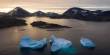
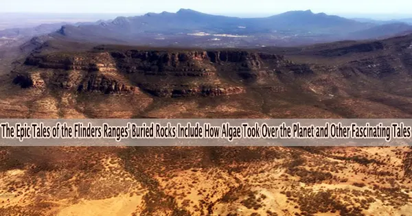
Earth was not always so hospitable. The Flinders Ranges in South Australia, a location that is currently competing for World Heritage status, include clues as to how it came to be so beautiful and nurturing.
Our new research seeks to better understand this near billion-year-old story. We discovered immense planetary upheaval recorded in the ranges.
In two related research projects, we’ve mapped how the continent that later became Australia responded to the most extreme climate change known in Earth’s history. We then dated this event.
The changes gave rise to algae. Their contributions include the evolution of the earliest animals more than 500 million years ago and the oxygen we breathe today. At the brand-new Nilpena-Ediacara National Park, which became operational in April 2023, the delicate bodies of these animals have been admirably conserved.
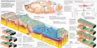
A superbasin on the shores of the Pacific
The rocks of the Flinders Ranges formed at the same time as the Pacific Ocean basin. 800 million years ago, the “dance of the continents” caused by plate tectonics tore North America and Australia apart. As a result, sand and muck were accumulated in a valley that eventually turned into an ocean.
Geologists call this the Adelaide Superbasin. “Super” because it is huge, and “basin” because it formed a depression where sediment could accumulate.
The superbasin stretches from Kangaroo Island in the south, to north of the Flinders Ranges and from Coober Pedy in the west to the Barrier Ranges of New South Wales in the east.
Rocks from the Adelaide Superbasin teach us how our world became what it is now at exceptional locations like Arkaroola and the national parks of Vulkathunha-Gammon Ranges and Ikara-Flinders.
Land of fire and ice
Until about 800 million years ago, Earth was an oxygen-poor but stable planet. So stable, in fact, this time has been nicknamed the “Boring Billion.”
That all changed 716 million years ago. The planet plunged into an 80-million-year Ice Age, the likes of which has never been seen again. It’s known as the Cryogenian Period.
At least two global glaciations during the Cryogenian, sometimes known as “Snowball Earth” events, occurred during which the world was completely covered in ice. The reason for this extraordinary cooling is still unknown. However, many scientists believe it has to do with massive volcanic eruptions that happened before the icy conditions. These volcanoes’ extremely weathered remnants have just recently been found in Arctic Canada and Alaska.
We know lava from volcanoes reacts with CO₂, dragging it out of the atmosphere. Scientists believe this reversed the pre-historic greenhouse effect and the planet cooled.
Part One: Picturing the world before the first animals
The first part of our new research reconstructs the shores of the balmy Pacific as this climate shock hit, causing vast ice sheets to lumber north and smothers the region for millions of years.
The Flinders Ranges are largely made up of boulder clay that was left behind by the glaciers as they carved through hills and valleys, flattening the land and leaving behind enormous expanses of boulder clay.
Our study focused on rare sedimentary rocks rich in magnesium that were partly shaped by microscopic bacteria. Small differences in the concentration of essential components are still present hundreds of millions of years later. We created a picture of highly salinized shallow oceans rich in bacterial life but lacking in anything else using these variants.
Part Two: Dating Snowball Earth
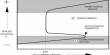
Dating sedimentary rocks is challenging. The grains of sand and pebbles that make up the rock formed elsewhere. They were carried by wind or water to the beach, or river, where they were deposited. Then, gradually, new rock formed.
Using established methods we can date one of the minerals in the sand (zircon). This uranium–lead method gives us the oldest possible age for sedimentary rock. That’s a reliable maximum age, but the true age of the rock could be much younger.
In the second part of our research we combined this established method with a new technique called “in-situ rubidium–strontium dating.” This enabled us to more accurately date the Snowball Earth rocks in the Flinders Ranges called the Sturt Formation.
The new technique attempts to directly date the “glue” that holds the grains of sedimentary rocks together. So we’re using a laser to date minerals that form as the sediment turns to rock. Some of these “authigenic” minerals (minerals that form “in place”) contain tiny amounts of radioactive rubidium. Over time, rubidium changes to strontium by radioactive decay.
Our study dates mudrock deposited within the glaciation. It is the first study to directly date sedimentary rocks that formed during the Snowball Earth event. This mudrock (a part of the Sturt Formation) formed around 684 million years ago.
Our “detrital zircon” method also gave us maximum ages of about 698 million years for a boulder clay below the mudrock, and about 663 million years from a boulder clay above the mudrock. These dates fit with estimates from elsewhere on the globe, suggesting the icy time likely lasted 50 million years.
Combining the findings from these two research, it is possible that the “Sturtian” glaciation, which occurred between 716 and 663 million years ago, was more active than previously believed. At least two glacial periods, or ice-advance and ice-retreat events, are most likely to have occurred. So the planet experienced more of a cold period rather than a completely frigid snowball.
The rise of the algae
These two research projects using rocks within the proposed World Heritage area, along with work from many other researchers, develops a picture of the world that led to the evolution of the first animals. We can better comprehend how the Earth system formed by considering the time of the geological events.
The frozen world of the Cryogenian stressed the microbial life that dominated the oceans way back then. Glaciers ground rock to powder and this powder turned the oceans of the day to a nutrient soup.
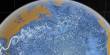
So when warmer times came, a previously minor player in the biosphere bloomed. This newcomer was algae, life with cells containing a nucleus. Essentially, seaweed.
They were bigger and more adept at photosynthesizing than the previous life. They unintentionally supplied the fuel for microorganisms to combine to form increasingly sophisticated multicellular life forms (metazoans), and ultimately the first mammals, by pumping their oxygen waste into the oceans and atmosphere.
A place of true world heritage
The rocks of the Flinders Ranges preserve so many stories, from the Dreamtime-formed shapes of the ranges, to the scars of the early mining history.
Our research into these rocks links the interdependence of Earth systems. We can read here about how plate tectonics and volcanoes affect the climate, how the climate provides nutrients for life, and how the ensuing life alters the chemistry of the ocean and the atmosphere, which in turn fuels the emergence of new life forms.
Unquestionably, the Flinders Ranges have a heritage significance to the rest of the globe because of the stories hidden in their slopes. We eagerly await news of world heritage listing, which is not expected until 2025 at the earliest.