The entire lunar surface has been completely mapped and uniformly classified for the first time. The ‘Unified Geologic Map of the Moon,’ as it is known, will serve as the definitive blueprint of the moon’s surface geology for future human missions and will be invaluable to the international scientific community, educators, and the general public.
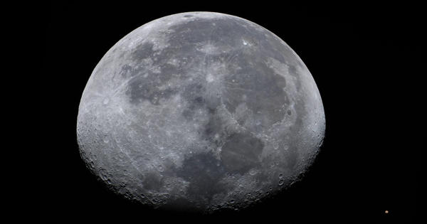
Have you ever wondered what kind of rocks make up the moon’s bright and dark splotches? The United States Geological Survey (USGS) has just released a new authoritative map to help explain the 4.5-billion-year history of our nearest neighbor in space.
For the first time, the entire lunar surface has been completely mapped and uniformly classified by scientists from the USGS, in collaboration with NASA and the Lunar Planetary Institute.
The “Unified Geologic Map of the Moon” will serve as the definitive blueprint of the moon’s surface geology for future human missions and will be invaluable to the international scientific community, educators, and the general public. The digital map, which depicts the moon’s geology in incredible detail, is now available online (1:5,000,000 scale).
“People have always been fascinated by the moon and when we might return,” said Jim Reilly, current Director of the USGS and a former NASA astronaut. “It’s wonderful to see the USGS create a resource that can help NASA plan for future missions.”
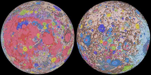
Scientists used information from six Apollo-era regional maps, as well as updated data from recent moon satellite missions, to create the new digital map. Existing historical maps were redrawn to match the modern data sets, preserving previous observations and interpretations. Along with combining new and old data, USGS researchers created a unified description of the moon’s stratigraphy or rock layers. This resolved issues from previous maps in which rock names, descriptions, and ages were inconsistent.
“This map is the culmination of a decades-long project,” said Corey Fortezzo, lead author and USGS geologist. “By connecting the exploration of specific sites on the moon with the rest of the lunar surface, it provides vital information for new scientific studies.”
The moon’s South Pole is particularly intriguing because it is much larger than the North Pole and there is a possibility of water in these permanently shadowed areas. Furthermore, the South Pole region contains the early Solar System’s fossil record.
The USGS astrogeology center coordinates NASA’s Planetary Geologic Mapping Program, which has produced 243 maps of nonterrestrial bodies in the solar system so far, the majority of which are physical maps that Fortezzo’s team is also digitizing. Although Mars and Jupiter’s moons Io and Ganymede have been globally mapped using the rigorous cartography standards for which the USGS is known (and global maps of Mercury, Jupiter’s moon Europa, Saturn’s moon Enceladus, and the asteroids Ceres and Vesta are currently in the works), Skinner believes this most recent version of the Moon’s is possible “the purest form of a planetary geologic map.”
Elevation data for the moon’s equatorial region came from stereo observations collected by the Terrain Camera on JAXA’s recent SELENE (Selenological and Engineering Explorer) mission. NASA’s Lunar Orbiter Laser Altimeter data were used to supplement the topography of the north and south poles.