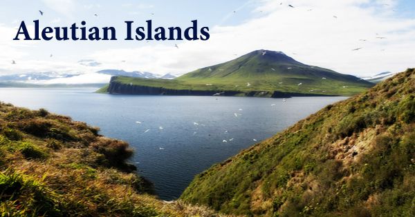
The Aleutian Islands (/əˈluːʃən/; Russian: Алеутские острова; Aleut: Unangam Tanaa, literally “Land of the Aleuts”, possibly from Chukchi aliat, “island”), a chain of small islands separating the Bering Sea (north) from the Pacific Ocean’s main part (south). A series of 14 large and 55 small volcanic islands belonging to the American state of Alaska and the Russian territory of Kamchatka Krai, also called the Aleut Islands or Aleutic Islands and known before 1867 as the Catherine Archipelago. The islands occupy 6,821 square miles (17,666 km2) and stretch from Alaska to the Kamchatka Peninsula for 1,200 miles (1,900 km). The archipelago includes both the westernmost part of the United States by longitude (Amatignak Island) and the easternmost part by longitude at a crossing longitude of 180°, at which point east and west longitude end (Semisopochnoi Island). However, in actual terms, the westernmost U.S. island is Attu Island, west of which the International Date Line runs.
The Fox Islands, the Islands of the Four Mountains, and the Andreanof, Rodent, and Close Islands are the main island groups from east to west. Geographically, the Komandor (Commander) Islands near Russia’s Kamchatka Peninsula are also part of the Aleutians. The islands form the northernmost portion of the Pacific Ring of Fire with their 57 volcanoes. Physiographically, they are a distinct portion of the broader province of the Pacific Frontier, which in turn is part of the larger physiographic division of the Pacific Mountain System. The islands span over 180° longitude and therefore consist of the westernmost region of the United States by longitude (Amatignak Island) and the easternmost region by longitude (Semisopochnoi Island). The islands lie in the Pacific Ring of Fire’s northernmost area.
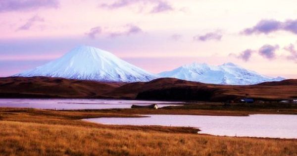
During the Aleutian Islands Campaign of World War II, fighting and skirmishes occurred on the islands. The only two invasions of the United States during that war were the Japanese landings and occupations of Kiska and Attu in June 1942. Most islands show traces of volcanic origin; some volcanoes have remained active near the center of Unimak Island, such as the Shishaldin Volcano (9,372 feet (2,857 meters)). The beaches are rugged and surf-worn, and the approaches are hazardous. The Near, Rat, Andreanof, The Islands of the Four Mountains, and the Fox Islands are the main islands from west to east.
The land rises sharply from the coasts in most areas to steep, bold mountains. The Unimak, Umnak, Amukta, and Seguam passes are the key navigational lanes around the chain. There are three stratigraphic units in the basement underlying the islands: an Eocene layer of volcanic rock, an Oligocene Miocene layer of sedimentary marine rock, and a Pliocene Quaternary layer of sedimentary and igneous rock. With heavy rainfall and mild temperatures, the Aleutian Islands experience an oceanic climate. The average annual temperature of the inhabited islands is around 38°F in January and 52°F in August.
In the Aleutians, the biggest islands are Attu (the farthest from the mainland), and the Fox Islands are Unalaska, Umnak, and Unimak. The climate of the archipelago is characterized throughout the year by reasonably uniform temperatures, high winds, heavy precipitation (mostly rainfall), and dense fog. The Aleutians are virtually devoid of trees, but are covered by grasses, sedges, and several flowering plants that grow luxuriantly. The native people of the islands are known as Unangan, but the non-natives are generally referred to as “Aleut”. Three mutually intelligible dialects that are closely related to the Eskimo-Aleut family are spoken by the Unangan. The Alaska Maritime National Wildlife Refuge’s Aleutian Islands unit (established in 1980) occupies 4,250 square miles (11,000 square km) and stretches between the islands of Unimak (east) and Attu (west). Tens of millions of seabirds, including auklets, puffins, murres, and fulmars, provide a breeding habitat for the Aleutians.
The archipelago’s axis near the mainland of Alaska has a southwest trend, but its orientation shifts to the northwest at Tanaga Island (about 178 ° W). This change in direction refers to a curve in the line of volcanic fissures that have led to the development of the islands through their products. The refuge has preserved the way of life of the local Aleuts, who have always survived by fishing and hunting, by preserving the wildlife of the islands (notably sea otters, sea lions, and seals) and by controlling killings. For several, the raising of blue foxes for the fur industry has created jobs.
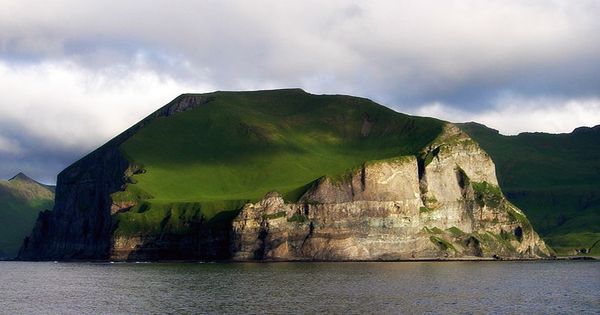
The islands have nearly eight thousand people, half of whom are on the main island of Unalaska. In the eastern islands and least in the west, the general elevation is highest. On the mainland, the island chain is a western continuation of the Aleutian Range. The Aleutians, rugged, majestic and attached to the sea, are part of an underwater world like no other on earth. Via the deep and shallow passes that bisect the narrow shelf of the Aleutians, the Bering Sea is connected to the rest of the North Pacific.
The islands are covered with a luxuriant, thick growth of herbage and shrubs instead of trees, including crowberries, bluejoints, grasses, sedges, and several flowering plants. Near the coast, there are areas of peat bogs. The endangered Aleutian shield fern contains endemic species. In the 70s and 80s, some animals were introduced, but most have become feral, including reindeer, goats, and foxes. By predation and feeding on seabird colonies, some of these introduced species have altered the ecosystem. A freighter broke up near Unalaska Island on December 8, 2004, pouring into the ocean an estimated 320,000 to 360,000 gallons (1,210,000 to 1,360,000 liters) of fuel oil and diesel fuel as well as more than 60,000 tons of soybeans. The resulting contamination killed several thousand birds and fish.
In 1976, the Aleutian Islands have declared a biosphere reserve by UNESCO. The Aleutians were one of 17 reserves of the biosphere in the United States excluded from the program in June 2017 at the request of the U.S. government. The Aleutians have long been populated by the Unangan, or Aleut, indigenous people who have lived on the islands for more than 10,000 years and have subsisted on the region’s marine resources. Even Aleutian plant life depends on the sea. Endemic Aleutian grasses, flowers, and shrubs depend on seabird guano to fertilize growth in a location where there are millions of birds, but no trees.
Information Sources: