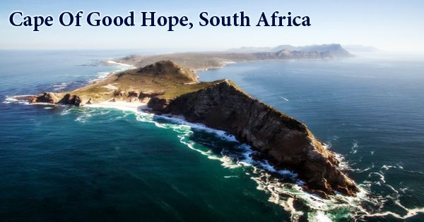
The Cape of Good Hope (Afrikaans: Kaap die Goeie Hoop (ˌkɑːp di ˌχujə ˈɦuəp); Dutch: Kaap de Goede Hoop (ˌkaːb də ˌɣudə ˈɦoːp); Portuguese: Cabo da Boa Esperança (ˈkaβu ðɐ ˈβoɐ (ɨ)ʃpɨˈɾɐ̃sɐ)), a rugged promontory at the southern end of the Cape Peninsula, in the province of Western Cape, South Africa. It’s a rocky promontory that was once assumed to be where the Indian and Atlantic Oceans met, although this has been confirmed by modern geographers as Cape Agulhas, about 90 miles southeast. A common myth is that the southern tip of Africa is the Cape of Good Hope. This misconception was based on the misbelief that the Atlantic and the Indian Ocean were the dividing points between the Cape.
After discovering the southern limits of the African continent, the Portuguese navigator Bartolomeu Dias first sighted it in 1488 on his return voyage to Portugal. One historical account notes that it was called Cape of Storms by Dias and renamed Cape of Good Hope by John II of Portugal (because its discovery was a good omen that India could be reached from Europe by sea); other accounts refer its present name to Dias himself. Instead, contemporary geographical information notes that the southernmost point of Africa is about 150 kilometers (90 mi) east-southeast of Cape Agulhas. At the point where the warm-water Agulhas current crosses the cold-water Benguela current and turns around on itself, the currents of the two oceans converge. Between Cape Agulhas and Cape Point (about 1.2 kilometers (0.75 mi) east of the Cape of Good Hope), the oceanic meeting point fluctuates.
Cape of Good Hope, South Africa
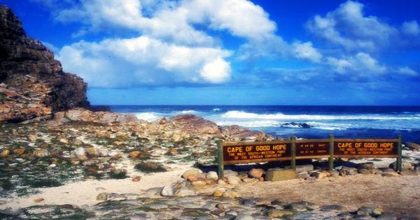
Legend has it that the spirits of The Flying Dutchman’s crew haunt the headland and its waters, but it is much more probable that passing visitors will see penguins, dashes, antelopes, and even a southern right whale. This 77.5-sq-km area of the National Park of Table Mountain contains spectacular scenery, fantastic walks, excellent birdwatching, and sometimes abandoned beaches. Some 250 species of birds, including cormorants and a family of ostriches that hang out near the promontory of the Cape of Good Hope, the continent’s southwest-most point, have been spotted here. In three other respects, the word Cape of Good Hope is also used:
- It is a portion of the National Park of Table Mountain, within which falls the cape of the same name, as well as Cape Point. This portion constituted the Cape Point Nature Reserve prior to its inclusion into the national park.
- It was the name of the early Cape Colony on the Cape Peninsula, founded by the Dutch in 1652.
- Just before the formation of the Union of South Africa, the term applied to the whole area that was to become the Cape of Good Hope Province in 1910. (usually shortened to the Cape Province).
In South African history, the Cape plays a significant role as a stopover point for trading ships sailing between Europe and the European colonies in the east. Initially, Europeans traded for food and water with the local Khoikhoi people, but in 1652, in the sheltered bay behind the Cape Peninsula, the Dutch East India Company built a small supply station, establishing the first European settlement in the area. The small station that gave refreshments to tired sailors has developed into the lively city of Cape Town today. A group of Huguenots (French Protestants) entered the Cape of Good Hope from the Netherlands on 31st December 1687. They had fled from France to escape religious persecution in France and fled to the Netherlands. The Dutch Republic was invaded by the French in 1795 during the Napoleonic Wars; hence, the Cape Colony became a British French vassal and enemy.
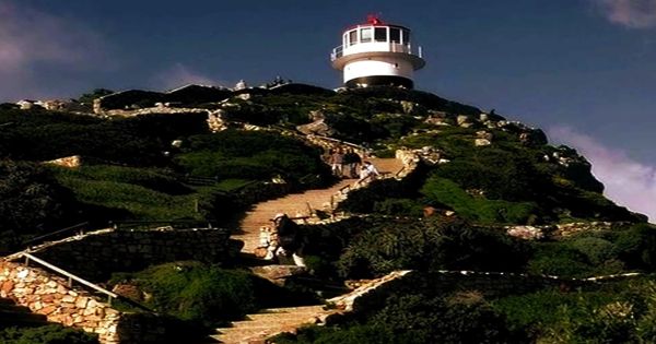
Lighthouse at Cape of Good Hope
The peninsula of the Cape is one of eight protected areas in the region, listed jointly by UNESCO as a World Heritage Site for the richness of its plant life. Although the Cape Floral Region’s 553,000 hectares make up just 0.5 percent of Africa’s territory, nearly 20 percent of the continent’s plants are represented. In Table Bay, at the northern end of the peninsula, Cape Town is about 50 kilometers to the north of the Cape. The peninsula forms False Bay’s western border. Geologically, the rocks contained in the two capes are part of the Cape Supergroup, and indeed across most of the peninsula, and are made from the same type of sandstones as Table Mountain itself. Spectacular scenery is provided by both the Cape of Good Hope and Cape Point; the entire southernmost section of the Cape Peninsula is a wild, rugged, scenic, and largely unspoiled national park.
The cape is located at the intersection of the warm Mozambique-Agulhas current from the Indian Ocean and the cool Benguela current from Antarctic waters, known for the stormy weather and rough seas encountered there. In a broader context, the word Cape was often used to denote the area of the European colony based on Cape Town and, later, the province of South Africa. It has been divided into three smaller provinces since 1994: The Western Cape, the Eastern Cape and the Northern Cape; portions of the province have been incorporated into the North West as well. A Mediterranean-type climate typified by mild, rainy winters and warm, dry summers characterizes the Cape of Good Hope and the southern tip of Africa. Cape Point typically sees summer daytime temperatures in the region of 80 degrees Fahrenheit at the headland’s tip and winter daytime temperatures around 68 degrees. Usually, annual precipitation is low.
In 1842, a black-maned lion from the Cape was described by Charles Hamilton Smith under the scientific name Felis (Leo) melanochaita. The Cape lion as a population, no longer seen as a subspecies of its own, is now extinct in the wilderness, although descendants may exist in captivity. The promontory, which is part of the Cape of Good Hope Nature Reserve (established in 1939) that covers the southern tip of the peninsula, is characterized by grass and low shrub vegetation. Around 1.2 miles (2 km) east of the Cape of Good Hope, there is a lighthouse at Cape Point. The winter rains are synonymous with ocean storms, which among sailors and explorers have made the capes of southern Africa notorious. Currently, one of the initial monikers of the Cape of Good Hope was the Cape of Storms. Partly connected with the Cape is the legend of the Flying Dutchman, a ghost ship forever wandering the rough seas.
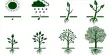
The area’s botanical diversity, one of the most remarkable in the world, will be noticed by tourists to the Cape of Good Hope and the surrounding region. Southwestern South Africa’s Cape Floral Area has more than 6,000 species of plants found nowhere else, including some that are part of the popular heaths of fynbos.
Information Sources: