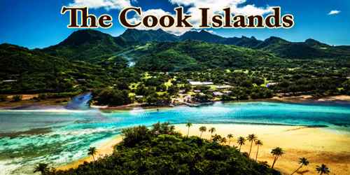
The Cook Islands (Cook Islands Māori: Kūki ‘Āirani), self-governing island state in free association with New Zealand, located in the South Pacific Ocean. It comprises 15 islands whose total land area is 240 square kilometres (93 sq mi). The Cook Islands’ Exclusive Economic Zone (EEZ) covers 1,800,000 square kilometres (690,000 sq mi) of ocean. Niue, the westernmost of the islands, is an administratively separate state. The administrative seat is Avarua, on the island of Rarotonga. Area (land only) 91.4 square miles (236.7 square km). Pop. (2011) 14,974.
New Zealand is responsible for the Cook Islands’ defence and foreign affairs, but these responsibilities are exercised in consultation with the Cook Islands. In recent times, the Cook Islands have adopted an increasingly independent foreign policy. Cook Islanders are citizens of New Zealand, but they also have the status of Cook Islands nationals, which is not given to other New Zealand citizens. The Cook Islands has been an active member of the Pacific Community since 1980.
The Cook Islands has a unicameral parliament with 24 elected members and a parliamentary term of four years. There is also a 15-member House of Ariki (Chiefs), established in 1966, composed of six Ariki from Rarotonga and nine from the outer islands. The Ariki advise the Government on land use and customary issues. There is full adult suffrage and registration is compulsory, although voting is not. The Head of Government is the Prime Minister, currently the Hon Henry Puna. Prime Minister Puna has held office since 2010 and was re-elected in 2014.
Elections were last held in June 2018. Preliminary results were inconclusive. The Democratic Party won 11 seats, the Cooks Islands Party 10 seats, One Cook Islands Movement one seat, with independent candidates winning two seats. Following the election, the Cook Islands Party joined forces with the independents and One Cooks Islands Movement to retain government.
The Cook Islands’ main population centres are on the island of Rarotonga (13,007 in 2016), where there is an international airport. There is also a larger population of Cook Islanders in New Zealand itself: in the 2013 census, 61,839 people said they were Cook Islanders, or of Cook Islands descent.
With over 168,000 visitors traveling to the islands in 2018, tourism is the country’s main industry, and the leading element of the economy, ahead of offshore banking, pearls, and marine and fruit exports.
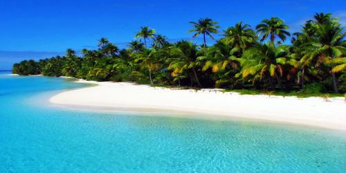
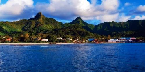
Each island is the top of one or more volcanoes, but only on the largest islands do the plugs and craters of now-extinct volcanoes still dominate the skyline; the highest of these rises to 2,139 feet (652 metres) at Te Manga, on Rarotonga, an island only 4 miles (6 km) wide. Many of the other islands of the southern group (Aitutaki, Atiu, Mangaia, Manuae, Mauke, Mitiaro, Palmerston, and Takutea) show various combinations of atoll and high-island formation. In the northern group (Manihiki, Nassau, Penrhyn, Pukapuka, Rakahanga, and Suwarrow), all except Nassau are atolls, narrow and low-lying sandbanks resting on circular reefs around lagoons rich in marine life.
Although its per capita GDP is high compared to many other Pacific Island countries, the Cook Islands economy faces many of the development challenges common to other small island developing states. These include relatively limited natural resources, remoteness from major trade and industrial centers, and a small labour force. Despite these constraints, the Cook Islands has developed successful tourism industry and the Government of Cook Islands has accorded high priority to its continued development. Developing marine resources within the Cook Islands’ large EEZ, including black pearl farming in the Northern Group of islands, is another government priority.
The Cook Islands are in the South Pacific Ocean, northeast of New Zealand, between French Polynesia and American Samoa. There are 15 major islands spread over 2,200,000 km2 (850,000 sq mi) of ocean, divided into two distinct groups: the Southern Cook Islands and the Northern Cook Islands of coral atolls. The islands were formed by volcanic activity; the northern group is older and consists of six atolls, which are sunken volcanoes topped by coral growth. The climate is moderate to tropical.
The Cook Islands consist of 15 islands and two reefs. All the islands lie within the tropics, though the southernmost just barely so. Because the Cook Islands are small, mid-ocean islands swept by the southeast trade winds, temperatures are generally moderate. Mean annual temperatures on the southern island of Rarotonga are in the mid-70s F (about 24 °C), but on the northernmost island of Penrhyn they are in the low 80s F (about 28 °C).
Because the land areas are so small, there are no rivers, and only the largest islands have even small streams. There are small freshwater lakes on the high islands of Mangaia, Atiu, and Mitiaro; saltwater lagoons inside all the atolls; and fringing lagoons between most islands and their outer reefs. The rain that falls on the atolls permeates the island coral and is naturally stored in a lens-shaped layer above the heavier salt water. The islanders must rely on wells and rainwater storage tanks to conserve their limited sources of water.
The languages of the Cook Islands include English, Cook Islands Māori, or “Rarotongan,” and Pukapukan. Dialects of Cook Islands Maori include Penrhyn; Rakahanga-Manihiki; the Ngaputoru dialect of Atiu, Mitiaro, and Mauke; the Aitutaki dialect; and the Mangaian dialect. Cook Islands Maori and its dialectic variants are closely related to both Tahitian and to New Zealand Māori. Pukapukan is considered closely related to the Samoan language. English and Cook Islands Māori are official languages of the Cook Islands; per the Te Reo Maori Act. The legal definition of Cook Islands Māori includes Pukapukan.
Only a limited range of plant life thrives in the north, with coconuts and pandanus being predominant. On the fertile areas of the southern islands, a wide range of tropical fruits and vegetables flourishes. Indigenous species include taro, yams, bananas, breadfruit, and sweet potatoes. Introduced species in many cases grown for export include citrus fruits, tomatoes, pineapples, papayas, beans, and zucchini.
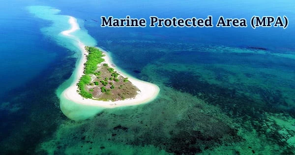
The original Polynesian settlers brought with them pigs, dogs, chickens, and a type of small rat. Those are still the main fauna, though a few goats, horses, and other animals have also been introduced. Some native birds became extinct in the 19th century after Europeans introduced cats. The kakerori, or Rarotongan flycatcher, an attractive tiny bird unique to Rarotonga, had been reduced by the early 1990s to about 30 breeding pairs. By the early 21st century, however, efforts by a small group of conservationists and landowners had succeeded in increasing the kakerori population to a viable level again. In 2012 the government announced plans to create a protected marine park encompassing the area around the southern islands, with an area of more than 400,000 square miles (1,000,000 square km).
In March 2019, it was reported that the Cook Islands had plans to change its name and remove the reference to Captain James Cook in favor of “a title that reflects its ‘Polynesian nature’.” It was later reported in May 2019 that the proposed name change had been poorly received by the Cook Islands diaspora. As a compromise, it was decided that the English name of the islands would not be altered, but that a new Cook Islands Māori name would be adopted to replace the current name, a transliteration from English.
Information Sources: