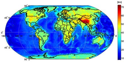
Basic purpose of this lecture is to present on Earth’s Surface Mapping. Earth’s Surface Mapping is a representation of something (Earth, stars, solar system, a building, etc. Here briefly focus on uses of maps: to determine where you are going; to act as a model of Earth’s surface; used to locate various places and to show the distribution of various features or types of materials. This lecture also review Latitude and Longitude.
Earth’s Surface Mapping