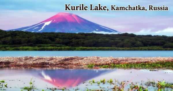
Kurile Lake (Russian: Кури́льское о́зеро, romanized: Kuríl’skoye Ózero) is a crater lake located in the territory of the South Kamchatka Sanctuary, Russia, on the south side of the Kamchatka peninsula. It is also referred to as Kurilskoye Lake or Kuril Lake. It is part of Kamchatka’s Eastern Volcanic Region, which, along with the Sredinny Range, forms one of Kamchatka’s volcanic belts. The lake is surrounded on all sides by rocky shores and dense brush. Generally speaking, the lake can only offer a leading position to the Kronotsky lake, depending on its size. The second-largest freshwater lake in Kamchatka (with an area of 12, 5 × 8 kilometers) is Lake Kuril. The subduction of the Pacific Plate under the Okhotsk Plate and the Asian Plate is the cause of these volcanoes. The Pauzhetka caldera was active during the Pleistocene before the Kurile Lake caldera formed, and was the origin of the Golygin ignimbrite, 443,000 ± 8,000 years old.
In the eastern part of the huge Pauzhetka caldera, Kurile Lake sits, but here it is known as a separate volcanic system. During the late Pleistocene and early Holocene, the low-rimmed Kurile Lake caldera formed in two phases. The Kurile Lake caldera erupted 41,500 years ago, and another minor eruption occurred between 9,000 and 10,000 years ago; then, between 6460 and 6414 BC, a major eruption occurred, creating the current caldera and the Kurile Lake ignimbrite and depositing ash as far as 1,700 kilometers (1,100 miles). The volume of this eruption is 140-170 cubic kilometers (34-41 cu mi), which makes it a 7-class VEI eruption and one of the largest during the Holocene.
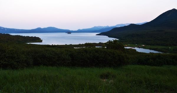
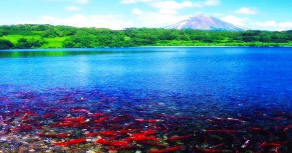
Life seems to flow in another quiet, leisurely way, loving every moment there. As in a fairytale, the surroundings are wonderful, so the territory of the Sanctuary, where Kuril Lake is located, has been included in the list of UNESCO World Heritage Sites since 1996. The volcanoes Diky Greben and Ilinsky grew up around the caldera as a result; Ilinsky’s last eruption was in 1911. A lake with a surface area of 76 square kilometers (29 square miles) and a maximum depth of 316 meters fills the caldera (1,037 ft). It includes the largest reserves of sockeye salmon in Asia.
The eruption resulted in an 8 × 14 km wide caldera being created, now mostly filled by Kurile Lake. The Serdtze Alaida (Heart of Alaid) is a rhyodacitic lava dome that developed at the end of the caldera-forming eruption and forms a small island rising 300 meters above the caldera floor in the center of the lake. The Sanctuary is difficult to enter due to its remote position from Kamchatka Krai’s capital city. To enter it, there are two options: by helicopter or an off-road vehicle. There are positive and negative aspects of all shipments.
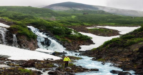
The two basins that make up Kurile Lake are separated by a 150-meter (490-foot) subaqueous ridge. A flat basin forms the middle portion of the lake; canyons cut into the slopes of the lake’s western side, where the rivers Ozernaya and Kumnynk open into the lake. Conversely, the Etamynk and Khakytsin rivers have formed an alluvial fan. The lake’s maximum depth is 316 meters (1,037 ft), with a mean depth of 195 meters on average (640 ft). Since this is the only federally administered reserve in the Kamchatka region, the sanctuary protection and regulations are extremely stringent. The protection of endangered animal and bird species, such as bighorn sheep, sea otter, brown bear, spotted seals, bean goose, Steller’s sea eagle and many others, is supervised by staff and volunteers working there.
Some of the slumping islands in the lake and others are volcanic cones; a 300 meter (980 ft) high lava dome is the’ Heart of Alaid’ (Serdtze Alaida). The lake contains a number of lava domes and pyroclastic cones. An explosion crater can be the Severnaya bay; lava flows reach into the lake from Ilinsky. Visiting the lake is restricted to quotas given by the state to decrease the anthropogenic impact on wildlife. Because of its size, the lake does not always freeze over in the winter. In September, the water temperature reaches 7.6 ° C and this is not a mean temperature equal to 10.8 ° C.
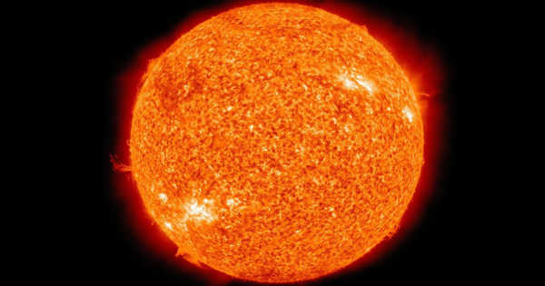
Kurile Lake is not the only volcano in Kamchatka to have had significant explosive eruptions that surpassed VEI 5 during the Holocene; Ksudach volcano had three such eruptions and Karymsky volcano had one. Kurile Lake’s volcanic rocks range from basaltic andesite to rhyolite. Potassium is found in small to medium quantities. The weather there is very complex and unpredictable. The proximity of the Sea of Okhotsk has a major effect on the atmosphere. On the Sanctuary’s territory, the sea is not calm, and the weather is often windy, foggy, or rainy.
The lake’s maximum depth is 316 meters, and the water is fresh. Its fault is a volcanic-tectonic depression that was created by the strong eruption hollowing out the Earth’s crust around 8300-8400 years ago. The majority of Kurile Lake’s eruption materials are rhyolite. Plagioclase, orthopyroxene, clinopyroxene, magnetite, and hornblende are among the minerals found, in decreasing order of importance. Away from the vent, the ash turns white, while deposits near the vent are often yellow. The depression formed was a caldera situated 104 meters above sea level, filled with rain water and melting snow. Lava layers create a few islands situated on the shore.
The caldera’s vegetation is mainly made up of bush and forest. There is no macrovegetation at the lake’s shore. The Etamynk, Vychenkiya, Kirushutk, and Hakytsin rivers all flow into the bay, and the Ozernaya river flows out to the west, into the Sea of Okhotsk. Many fish swim up the river to spawn and provide food for other fish. In the Kurile Lake region, the height of the pumice formations reaches more than 100-110 meters. The number of fish is between 260,000 and over 6 million in the lake. In Asia, the stocks found at Kurile Lake are the biggest. Lake Kuril is a fascinating location for a number of reasons. For visitors, there are fascinating neighbors.
3.7–4.2 billion metric tons of water, 43–49 million tons of chlorine, 8.6–9.8 million tons of fluorine, and 26–29 million tons of sulfur were released during the eruption, equivalent to the quantities released by Tambora in 1815 and Huaynaputina in 1600. There are areas where capes can be used to help achieve natural harmony. The Tugumynk cape is located to the south of the lake, while the Pulomynk cape is located to the northwest. The village of Pauzhetka is situated on the border of the Sanctuary, where a group of tourists rest for a night, taking a vehicle-trekking tour.
Water from the melting of snow and glaciers on the volcano’s slopes flows through the Earth’s crust, diluting minerals before evaporating to the surface. The minerals settle easily and turn a ghostly white color in a variety of riverbeds and streambeds. The eruption wreaked havoc on southern Kamchatka’s vegetation, resulting in an ecological disaster. All vegetation would have been wiped out close to Kurile Lake, and deposits left by the eruption would also have hindered the revegetation. The Kuril Lake is visited by passerine animals during their autumn migrations. Their option is very easy to explain: Kuril Lake is the only appropriate place to stay before leaving the peninsula of Kamchatka via the Lopatka Cape. There are clearly no stopping points for the passerines to the south.
Information Sources: