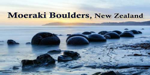
The Moeraki Boulders are a group of large spherical “stones” on Koekohe Beach near Moeraki on New Zealand’s Otago coast between Moeraki and Hampden. They occur scattered either as isolated or clusters of boulders within a stretch of beach where they have been protected in a scientific reserve. The erosion by wave action of mudstone, comprising local bedrock and landslides, frequently exposes embedded isolated boulders. These boulders are grey-colored septarian concretions, which have been exhumed from the mudstone enclosing them and concentrated on the beach by coastal erosion.
Ancient Maori legend says these boulders are gourds or food containers, washed ashore from the wreckage of a canoe that brought their ancestors to New Zealand’s South Island. Another theory suggests they are alien eggs. Geology says they formed in sediment on the seafloor around 65 million years ago, eventually choosing Koekohe Beach as their home. These boulders are actually concretions that have been exposed through shoreline erosion from coastal cliffs. Even today, there are still boulders remaining in the mudstone that will, eventually, fall on to the beach as they come to lose due to erosion!
In 1848 W. B. D. Mantell sketched the beach and its boulders, more numerous than now. The picture is now in the Alexander Turnbull Library in Wellington. The boulders were described in 1850 colonial reports and numerous popular articles since that time. In more recent times they have become a popular tourist attraction.
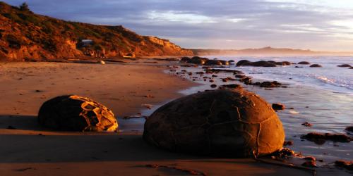
(The Moeraki Boulders at sunrise)
The boulders are one of the most fascinating and popular attractions on the South Island. They originally started forming in ancient seafloor sediments around 60 million years ago, and the largest boulders are estimated to have taken about 4 million years to get to their current size. Some of the boulders weigh several tonnes and the largest ones can be over 2 meters wide! Similar large spherical concretions have been found in many other countries.
Approximately one-third of the boulders range in size from about 0.5 to 1.0 meters (1.6 to 3.3 ft) in diameter, the other two-thirds from 1.5 to 2.2 meters (4.9 to 7.2 ft). Most are spherical or almost spherical, but a small proportion is a slightly elongated parallel to the bedding plane of the mudstone that once enclosed them.
Maori legend tells that the boulders are remains of calabashes, kumaras and eel baskets that washed ashore after the legendary canoe, the Araiteuru was wrecked at nearby Shag Point (Matakaea).
Neither the spherical to subspherical shape or large size of the Moeraki Boulders is unique to them. Virtually identical spherical boulders, called Koutu Boulders, are found on the beaches, in the cliffs, and beneath the surface inland of the shore of Hokianga Harbour, North Island, New Zealand, between Koutu and Kauwhare points. Like the Moeraki Boulders, the Koutu Boulders are large, reaching 3 meters (10 ft) in diameter, and almost spherical. Similar boulder-size concretions, known as Katiki Boulders, are also found on the north-facing shore of Shag Point some 19 kilometers (12 mi) south of where the Moeraki Boulders are found. These concretions occur as both spherical cannonball concretions and flat, disk-shaped or oval concretions. Unlike the Moeraki boulders, some of these concretions contain the bones of mosasaurs and plesiosaurs.
The Boulders are a very popular spot for photographers and with good reason!
Early morning and late afternoon are the prime times for photography when brilliant soft sunlight is cast across the rocks; making for spectacular photographic opportunities. Other times, such as when storms are rolling in, provide an atmosphere and scene that can’t be matched anywhere else in New Zealand or the world!
The Moeraki Boulders are concretions created by the cementation of the Paleocene mudstone of the Moeraki Formation, from which they have been exhumed by coastal erosion. The main body of the boulders started forming in what was then marine mud, near the surface of the Paleocene seafloor. This is demonstrated by studies of their composition; specifically the magnesium and iron content, and stable isotopes of oxygen and carbon. Their spherical shape indicates that the source of calcium was mass diffusion, as opposed to fluid flow. The larger boulders, 2 meters (6.6 ft) in diameter, are estimated to have taken 4 to 5.5 million years to grow while 10 to 50 meters (33 to 164 ft) of marine mud accumulated on the seafloor above them. After the concretions formed, large cracks known as septaria formed in them. Brown calcite, yellow calcite, and small amounts of dolomite and quartz progressively filled these cracks when a drop in sea level allowed fresh groundwater to flow through the mudstone enclosing them.
Although now protected by law, it is believed that many smaller boulders were removed from the beach prior to legislation. The newsletter item by Hayward (2014) considers the issue of geoconservation. The earthquake near Kaikoura in late 2016 has allowed similar boulders to be viewed following the uplift of the seafloor in that event.
Information Sources: