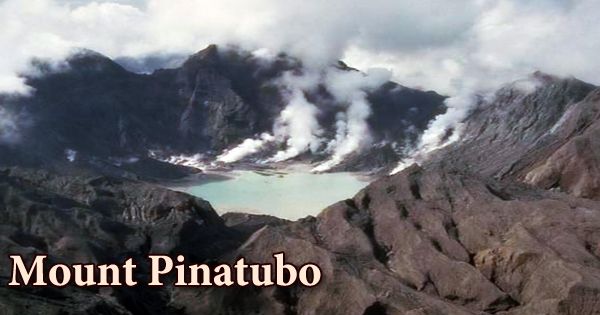
Mount Pinatubo (Sambal: Bakil nin Pinatobo; Kapampangan: Bunduk/Bulkan ning Pinatubu, Bunduk ning Apu Malyari; Pangasinan: Palandey/Bulkan na Pinatubu; Ilocano: Bantay Pinatubo; Tagalog: Bundok/Bulkang Pinatubo IPA: pinɐtubɔ) is a volcano in western Luzon, Philippines, that erupted in 1991, causing widespread devastation for the first time in 600 years. It’s a modern-day example of highly explosive eruptions and deposits in a plate environment that’s similar (but not identical) to Cwm Idwal. Before the pre-eruption volcanic activities in 1991, just before June, most people were unaware of its eruptive past. Pinatubo had been heavily eroded, making it inconspicuous and hidden from view. It was covered in thick forests that housed a population of thousands of indigenous Aetas.
Pinatubo was 1745 m high before the eruption in 1991 (about 250 m higher than it is now) and just 200 m higher than the surrounding peaks, which are remnants of older volcanic edifices of Mt Pinatubo and hid it from distant views. Mount Pinatubo is about 55 miles (90 kilometers) northwest of Manila, and it grew to a height of about 4,800 feet (1,460 meters) before erupting. Mount Pinatubo’s first volcanic activity is believed to have started around 1.1 million years ago, but it ceased several tens of thousands of years before the start of this second, modern phase of activity, which began around 33,000 BC after a long period of dormancy.
The evacuation of tens of thousands of people from the surrounding areas was prompted by predictions made at the start of the climactic eruption, saving many lives. Pyroclastic floods, pyroclastic dumps, and subsequent flooding lahars triggered by rainwater remobilizing earlier volcanic deposits wreaked havoc on the surrounding areas. For years after the eruption, this wreaked havoc on infrastructure and altered river systems. Pinatubo eruptions are notorious for being violent and cataclysmic. Each eruption expelled massive quantities of material and, like the Cwm Idwal eruption, pyroclastic flow deposits covered vast areas. The most notable eruption of Mount Pinatubo occurred in 1991, though it was one of the smaller ones in the volcano’s recent eruptive history.
The caldera was most likely formed by a much larger eruption that occurred 35,000 years ago. The repercussions of the eruption in 1991 were felt all over the world. It expelled approximately 10 billion tonnes (1.11010 short tons) of magma, or 10 km3 (2.4 cu mi), and 20 million tonnes (22 million short tons) of SO2, dumping massive amounts of minerals and radioactive metals into the atmosphere. It was the twentieth century’s second-largest volcanic eruption, with a significant effect on a densely populated region. In the years 1991–1993, global temperatures fell by around 0.5°C (0.9°F), and ozone depletion increased significantly.
The Zambales Ophiolite Complex, an easterly-dipping portion of Eocene oceanic crust that was uplifted in the late Oligocene, flanks Pinatubo to the west and is most likely underlain by it. The volcano is located 87 kilometers (54 miles) northwest of Manila, the Philippines’ capital. The US maintained two major military bases in the area near Mount Pinatubo. The Tarlac formation is located in the north, east, and southeast of Mount Pinatubo, and it formed contemporaneously with the area’s oldest known volcanic centers, such as Mount Mataba or the Dizon Mine diorite, a subsurface remnant of an ancient vent.
Before the 1991 eruption, Mount Pinatubo’s summit was 1,745 meters (5,725 feet) above sea level, just 600 meters (2,000 feet) above neighboring plains, and just 200 meters (660 feet) above surrounding peaks, which largely obscured it from view. Following the 1991 eruption, scientists conducted extensive fieldwork on the present-day Pinatubo deposits in order to better understand the volcano’s eruptive past. The eruptive style at Pinatubo was explosive, with a huge amount of gas, explosives, lava, tephra (volcanic rock lumps), and pyroclastic density currents, similar to Cwm Idwal (hot mixtures of gas and rock).
The eruption expelled more than 5 km3 of material in total. This massive amount of volcanic rock transformed Luzon’s landscape, filling some valleys while emptying others. The top of the volcano collapsed into a 2.5 km diameter caldera, while some parts of the volcano extended. The pyroclastic density current deposits (ignimbrites) were 200 m thick and similar to those found in Cwm Idwal’s Pitts Head Tuff, but much thicker and chemically weathered due to the tropical climate. Mount Cuadrado, Mount Negron, Mount Mataba, and Mount Pinatubo are all part of the Cabusilan sub-range of the Zambales Mountains, which includes Mount Cuadrado, Mount Negron, Mount Mataba, and Mount Pinatubo. The Eurasian Plate slides under the Philippine Mobile Belt along the Manila Trench to the west, forming subduction volcanoes.
About 9000 years ago, a massive explosive eruption occurred. Along the road between Sitio Pasbul, Camias, Porac, and the Gumain River, pyroclastic-flow and tephra-fall layers were exposed. The pyroclastic flows topped the Tayawan caldera’s southeastern rim and nearly or fully filled the Gumain River valley. Ancestral Pinatubo’s activity appears to have started about 1.1 million years ago and ended thousands of years or more before the birth of “modern” Pinatubo. Most of the rugged land around the current volcano is made up of “ancestral” Pinatubo remains.
The gas production was equally impressive; 18 million tons of sulfur dioxide were pumped into the atmosphere, resulting in a cloud that encircled the globe several times. Mount Pinatubo’s most recent eruption occurred in 1993. The forested area of Mount Pinatubo was also home to a tribe of Aeta people, tiny, dark-skinned, and kinky-haired people thought to be the closest descendants of the Philippines’ first settlers, who arrived 30,000 years ago through land bridges linking the Philippines to the Asian mainland. They considered the mountain the home of Apo Namalyari, the Great Protector and Provider.
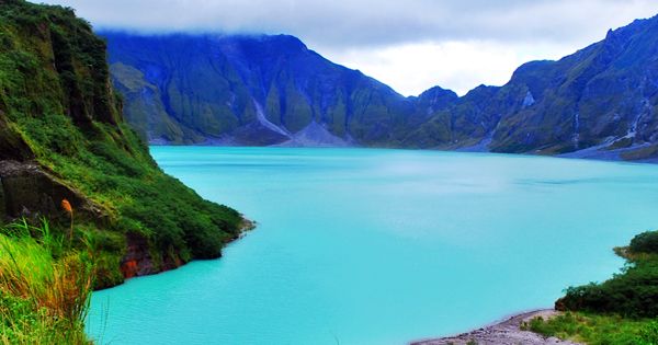
The 1991 caldera was later flooded with water from annual monsoon rains, resulting in the creation of Lake Pinatubo, a crater lake. An island was created by a rising lava dome in 1992, which was gradually submerged by the lake. The lake was initially hot and acidic, with a pH of 2 and a temperature of about 40°C (104°F). The caldera lake on Mt Pinatubo rose to dangerous levels in 2001, and the water turned a different color in January 2004.
Information Sources: