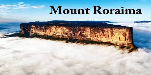
Mount Roraima, Spanish – Cerro Roraima or Monte Roraima (ˈmõtʃi ʁoˈɾajmɐ), and Cerro Roraima, is the highest of the Pakaraima chain of tepui plateaus in South America. First described to Europeans by the English explorer Sir Walter Raleigh during his 1595 expedition, its 31-square-kilometre (12-square-mile) summit area is bounded on all sides by cliffs rising 400 metres (1,300 ft). The mountain also serves as the tripoint of Venezuela, Guyana and Brazil. Raleigh learned about it from indigenous peoples, who lived there before arrival of Europeans in the 15-1600’s.
About 9 miles (14 km) long and 9,094 feet (2,772 metres) high, it is the source of many rivers of Guyana, and of the Amazon and Orinoco river systems. Mount Roraima is the highest point in Guyana. The triple border point is at 5°12′08″N 60°44′07″W, but the mountain’s highest point is Laberintos del Norte.
Rising up from the surrounding lowlands, Roraima is an island in the sky that has been intriguing people for centuries, with its bizarre rock formations, waterfalls, and meat-eating plants. This tepui (table-top mountain) was even the inspiration for Arthur Conan Doyle’s famous novel The Lost World.
The 85% of this tepui is in Venezuelan territory (Bolívar state), 10% in the territory of Guyana. (Cuyuni-Mazaruni, Zone also claimed by Venezuela), and 5% belongs to the state of Roraima in Brazil.
Indigenous population of the region believed that table-top mountains were meant to serve as houses for their gods. The definition of the table-top mountains in local indigenous Pemon language is tepui, i.e. “the house of gods”. Mount Roraima, the tallest of the table-top mountains is almost always surrounded by whitish clouds and mist that gives it a magical and mystical appearance. The local Indians used to call the mountain “the navel of the earth”. According to their beliefs the progenitor of all people the mother goddess lives at the very top of the mountain. The mountain is connected to the majority of the myths and legends of locals.
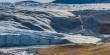
Many of the species found on Roraima are unique to the tepui plateaus with two local endemic plants found on Roraima summit. Plants such as pitcher plants (Heliamphora), Campanula (a bellflower), and the rare Rapatea heather are commonly found on the escarpment and summit. It rains almost every day of the year. Almost the entire surface of the summit is bare sandstone, with only a few bushes (Bonnetia roraimae) and algae present. Low scanty and bristling vegetation is also found in the small, sandy marshes that intersperse the rocky summit. Most of the nutrients that are present in the soil are washed away by torrents that cascade over the edge, forming some of the highest waterfalls in the world.
This mountain is one of the most unique natural rock formations on the Earth not only because of its form but also because of its origin. Tepuis are believed to be the remains of a large sandstone plateau that once was lying between the northern border of the Amazon Basin and Orinoco, between the Atlantic coast and the Rio Negro. The tepuis were formed as a result of changes in the Earth’s surface. Most probably they were formed when the continents drifted apart several billion years ago and South America was separated from West Africa.
Since long before the arrival of European explorers, the mountain has held a special significance for the indigenous people of the region, and it is central to many of their myths and legends. The Pemon and Kapon natives of the Gran Sabana see Mount Roraima as the stump of a mighty tree that once held all the fruits and tuberous vegetables in the world. Felled by Makunaima, their mythical trickster, the tree crashed to the ground, unleashing a terrible flood. Roroi in the Pemon language means blue-green and ma means great. It is also said to have inspired Paradise Falls from the Pixar film “Up”.
For a long time scientists believed that there are no caves in Roraima, however in 2003 one of the world’s largest system of quartz caves was discovered here. It is called Cueva Ojos de Cristal, which translated from Spanish means “the cave of crystal eyes.” The system is located on the Venezuelan side of the mountain in the Canaima National Park. It extends for nearly 11 kilometers in length and descends to a depth of 72 meters below the surface of Roraima. The highest point of Roraima is 2810 meters, while its clean prominence is 2338 meters. The plateau on the summit of Roraima has an area of around 30 square kilometers.
Mount Roraima is one of the highest tepuis in Canaima National Park. It is also one of the most easily accessible and a popular hiking destination, although it is a demanding, multi-day hike. The temperature drops as the elevation rises and Roraima is often cloudy, misty, or raining, so hikers need to be prepared to face the elements.
The 2013 Austrian documentary Jäger des Augenblicks – Ein Abenteuer am Mount Roraima (Moment Hunters – An Adventure on Mount Roraima) shows rock climbers Kurt Albert, Holger Heuber, and Stefan Glowacz climbing to the top of Mount Roraima from the Guyana side. Similarly, in 2010 Brazilian climbers Eliseu Frechou, Fernando Leal and Márcio Bruno opened a new route on the Guyanese side, climbing to the top in 12 days of a very difficult vertical wall climb. They called the new route Guerra de Luz e Trevas (Portuguese for “War of Light and Darkness”) and classed it as 6° VIIa A3 J4. A 28-minute Vimeo video called ‘Dias de Tempestade’ (Days of Storm) is available documenting their climb (English subtitles, audio in Portuguese).
Information Sources: