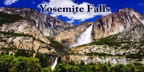
Yosemite Falls is the iconic symbol of the grandeur and beauty of Yosemite National Park, east-central California, U.S., near Yosemite Village. They were formed by creeks tumbling into the Yosemite Valley over the edges of hanging tributary valleys (which eroded more slowly than the glacial- and river-carved Yosemite Valley and were left “hanging” above it) into the Merced River below.
Located in the Sierra Nevada of California, it is a major attraction in the park, especially in late spring when the water flow is at its peak.
Yosemite Falls consists of three drops, this configuration caused by the interruption of the vertical joints (cracks in the underlying rock) by two horizontal joints. The Upper Yosemite Fall drops 1,430 feet (436 meters) and the Lower 320 feet (98 meters), with a series of cascades between; the total drop is 2,425 feet (740 meters), creating one of the world’s highest cataracts, the highest in North America. The flow of the falls is variable, with maximum flow reached in May and June; it diminishes greatly in years of little precipitation. The falls are one of the park’s most scenic and popular attractions.
Yosemite Creek, which feeds the waterfall, drains a very large area of the High Country (reportedly 43 square miles).
Generally, snowpack accumulated from Winter storms provides the falls most of its water. The water would remain locked up as snow and ice until the warmer climate of Spring and early Summer converts all that solid water into liquid water. The falls flow most vigorously during the spring snowmelt.
Yosemite Falls can be appreciated from multiple viewpoints in the Yosemite park. The meadows along with the eastern valley floor host impressive views, as does the popular Lower Yosemite Falls Trail. Southern rim vistas such as Glacier Point, Taft Point, and the Four-Mile Trail offer an elevated perspective, while the Yosemite Falls Trail and Yosemite Falls Overlook provide an up-close and personal experience.
The main village of the native people of Yosemite Valley, the Ahwahneechee, was located at the base of the falls. The Ahwahneechee people called the waterfall “Cholock” (“the fall”) and believed that the plunge pool at its base was inhabited by the spirits of several witches, called the Poloti. An Ahwaneechee folktale describes a woman going to fetch a pail of water from the pool and drawing it out full of snakes. Later that night, after the woman had trespassed into their territory, the spirits caused the woman’s house to be sucked into the pool by a powerful wind, taking the woman and her newborn baby with it.
In all but the wettest years, the falls cease flowing altogether in late summer or fall. A very small number of rock climbers have taken the opportunity to climb the normally inaccessible rock face beneath the falls, although this is an extraordinarily dangerous undertaking; a single afternoon thunderstorm could restart the falls, sweeping the climbers off the face.
Visitors don’t have to hike or even get out of their car to appreciate the beauty of this waterfall, but the most complete view, and one of the best views, of the falls, is from the start of the Yosemite Falls hike, along the non-handicapped route on the left side of the river. Visitors can walk right to the base of the falls with minimal effort and feel the mist sweeping over them. Another outstanding perspective can be had from the picnic site at the Swing Bridge.
Lower Yosemite Fall is easily accessible near the Yosemite Lodge in Yosemite Valley. The top of Upper Yosemite Fall may be reached via a steep, strenuous, and usually crowded 3.5 miles (5.6 km) hike beginning near Camp 4. The Upper Fall may also be reached via several routes from the Tioga Road to the north.
Information Sources: