Introduction
1.1 Statement of the Problem
Flooding of Dhaka city, in recent years, throughout the wet season has become a major concern for all. With forty percent of the countries land mass only one meter above the sea level. Dhaka city has an area of 360 square kilometers virtually built on and spread over low lying deltaic zone. The city of Dhaka is said to have once plus-minus 50 criss-cross canals facilitating upland drainage. In the process of urbanization of Dhaka as water bodies have been converted into lands and lands has been converted from fields or forestry to roads and buildings Most of them in any case are disappearing day by day.
Dhaka is covered by two Flood Action Plans (FAP). The Greater Dhaka Protection Project (FAP-8A) and The Dhaka integrated Flood Protection Project (FAP-8B). The flood retention ponds are an important component of the proposed FAP-8A and FAP-8B flood protection schemes. The policy of the Flood Retention Ponds directly demarcate the location of retention pond which should be the subject of detailed geologic survey to ensure that the city’s natural drainage system is not compromised and that the effects of water logging are minimized.
These planning proposals have not been implemented since the completion of DMDP (1995-2015).It has been taken to implement the plans in kallayanpur area. As the Detailed Area Plan (DAP) has not been completely prepared, it is difficult to demarcate the actual location of the retention ponds. Subsequently many public, private, individual interest groups take the opportunity and filled the low lands hurriedly. Rapid population growth and high demand for the basic need-shelter/housing makes the situation complex.
These planning proposals are violated for many other reasons such as domination of political/elite group, no specific plan and location of the retention ponds, lack of public awareness and education etc. The lack of an efficient storm sewer system in Dhaka City also contributes to the reduction of water carrying capacity, causing water logging, drainage congestion and many other troubles throughout the monsoon season. So these constraints have to be identified and to reduce the vulnerability of flood in the perspective of Dhaka city it is essential to protect and preserve flood retention pond.
1.2 Background of the Study
The population of Bangladesh is about 130 million. Urban population has increased from 1.81 million (4.33% of total population) in 1951 to 25.2 million in 1990. The current urban population is more than 30 million (25% of total population), and is projected to exceed 58 million (36% of total population), by the year 2010 (Khalequzzaman, 2005). This rapid population growth creates extra pressure on the land. People are intended to fill up the agricultural lands and water bodies for housing developments and roads.
Disorganized urban development schemes exist due to lack of strategic area plan and detailed area plan in Dhaka city. Therefore, the allocation of infrastructure and public services in residential areas could not be done for a comprehensive benefit for the entire city. For instance, this increasing density has impacts on infrastructure and it creates overload of water and sewerage system in the city.
The drainage system in the city was not upgraded keeping pace with the rapid urbanization while around half of the canals in the city dried up or have been illegally filled in and occupied over the last two decades causing water logging in many parts of the city during the rainy season. About seventeen out of 43 canals in the city have already been filled up entirely while the rest 26 have narrowed down due to unplanned urbanization (IWM, 2006).
A densely populated city like Dhaka requires 25 percent wetland for ecological balance and sustainability of habitats. But Dhaka has less than ten percent wetland, which too is threatened. Uncontrolled encroachment of the city’s other water bodies by land developers as well as individuals have already affected city life in many ways. Lack of adequate floodwater retention ponds directly results in water logging during rain, unhealthy retention of sewage and outbreak of diseases.
As the water bodies and canals in different areas have been filled up either partially or entirely, the pressure on pump houses to pump out water has increased. The capability of pump houses needs to be improved and the number of pump houses across the city has to be increased. This scenario enlightens about the drainage congestion, drainage problem, water logging and many other socio-economic problems and without the implementation of the planning proposals timely it would be deceitful for human being and for its environment. So this study assesses the planning proposals and compares it with the present situation and also identifies the constraints behind the implementation of the plans in the area.
1.3 Description of the Study Area
Dhaka, the capital and the largest city of Bangladesh is located in the central region of the flat deltaic plain of the three major international rivers, the Ganges, the Brahmaputra and the Meghna. The city is surrounded by the distributaries of these three major rivers. Geographically, Dhaka is situated on the northern bank of the river Buriganga, The Balu River in the east and Turag bound it in the west and north. In spite of its water confinement on all sides Dhaka is considerably high above the water of surrounding rivers in ordinary seasons of inundation. The elevation of Greater Dhaka lies between 2 to 13 m above mean sea level (msl). Most of the urbanized area lies at the elevation of 6 to 8 m above msl (Tawhid, 2004).
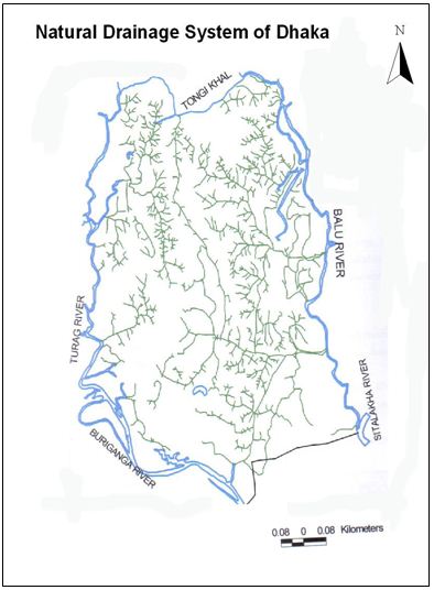
The major drainage channels (locally known as khal) in the city are Abdullahpur Khal, Degun Khal, Diabari Khal, Kallyanpur Khal and Dholai Khal, which drain the western part of the city to the Tongi khal /Turag/Burigonga river system, while Jerani khal, Segunbagicha khal and Begunbari Khal drain to the Balu rivers. These khals carry storm water runoff as well as untreated wastewater into the peripheral river system. Besides Jerani, Segunbaghicha and Begunbari khals, there are many other khals draining the eastern part of Dhaka (IWM, 2006).
The DMDP Master Plan has categorized the various areas of the City into 19 (nineteen) Spatial Planning Zones (SPZs). Some of these have been further subdivided into sub-zones, so that the actual total becomes 26. Master Plan particularly identified specific features of the each SPZs, and demarcated few rivers, Khals, small water bodies/retention ponds, lake and open spaces and obliged legally to protect them from illegal developments. Specifically fourteen SPZs are identified mentioning its mouzas as flood flow zones, and clearly prohibited earth filling without due permission from the concerned authority. SPZ 5 is taken as the study area and the retention pond of Dhaka city and study area are shown in the figure 1. 1.
1.4 Objective of the Study
The overall objectives of the study are as follows: the objective is to assess the reality of implementation of retention ponds and to identify the constraints of the implementation of the planning proposals. Analyzing the legal aspects and the proposals for the protection of the retention ponds and thereby identifying the rules violated by the several groups, problems created by the violation will also be a focus of the study. Finally; the present study would try to propose some recommendation aiming at the overall welfare of the city.
To review the planning proposals of retention ponds in Dhaka city
To compare total flood water and the capacity of retention pond to assess the reality of implementation of retention pond in the study area
To identify the constraints of plan implementation
To give some recommendations to improve the drainage situation
1.5 Justification of the Study
The flood retention ponds are designed to reduce the intensity of local flooding within the protected areas and to reduce pumping requirements, and as such are an integral part of the proposed flood protection schemes. Their location should be the subject of detailed geological survey to ensure that the city’s natural drainage system is not compared and that the effects of water logging are minimized.
Retention ponds are more often used in water climates so they tend to retain water for extended periods of time and attract and support wildlife such amphibians and birds. Retention ponds are most often associated with human development in a given area; as buildings and streets are built and cover up absorbent soil; the ability of the landmass to absorb water from rain or flooding is lessened. Since the water must flow somewhere, a retention pond is built on the site to localize the effects of reduced water absorption. These structures are frequently used to act as a replacement for the natural absorption of a forest or other natural process that was lost when an area is developed. These structures almost always contain water; they are designed to limit access by people. This enhances their ability to attract and support wildlife. They are usually fenced to prevent entry and minimize risks.
The DMDP has clearly marked the area for flood retention pond and the water body is a vast natural retainer for storm water, servicing a 40 sq kilometer area in the city. The detailed area plan (DAP), one of the major components of the Dhaka Metropolitan Development Plan (DMPD), could not be prepared in 13 years, leading to unplanned urbanization. The DAP is important for urban planning and to ensure proper use of land of the 1530-square kilometer of the capital. Rajuk’s delay in preparing the DAP facilitated the private land developers to destroy city’s natural environment, wetlands, flood retention ponds and open spaces within and in the periphery of the city.
This study will identify the problems of the implementation of the plans in the context of the planning proposals. In many reports it only discusses about the drainage problem and very few works have been done with the conditions of retention ponds. So it is important as a planner to predict the constraints of implementation of the plans and provide some recommendation for sustainable urban development.
1.6 Scope of the Study
It is important to realize that very few urban drainage systems are designed and built as a complete system. To overcome this problem of Dhaka city, it is necessary to find out the inherent causes of this problem considering its associated impacts on human life. The FAP 8A and FAP 8B includes the drainage functions with the flood protection schemes. The proposed retention ponds of DMDP are the key and fundamental issue of flood protection schemes. The Dhaka Metropolitan development Plan indicates that until a detailed area plan is prepared for sub-area, land use management functions will be exercised through the policies, guidelines and principles found in the structure plan and urban area plan (RAJUK, 2008).
The DAP report consists of reports and maps scale as appropriate for effective communication and interaction with supporting documents. This report has considered continuing population pressure, incompatible land use and immense pressure on urban facilities and services creating an acceptable living condition which now needs urgent intervention (RAJUK, 2008).But it is 13 years passed the DAP has not published for many reasons. And this delay of plan preparation and implementation give chance for unplanned development of the city because without DAP efficient land management would not be possible. This study will be confined its area of analysis on the planning proposals of retention ponds in Dhaka city. It will provide the general information about the proposals, of the ponds, description of this project implementing groups, information about the pump station and its capacity. This study will also assess the retention ponds size with the rapid population growth as the provision of housing for this people is urgency for the city. And finally it will focus on the constraints of plan implementation and provides some recommendations for the improvement of this situation.
1.7 Limitations
Very few studies were conducted related to retention pond of Dhaka City. As a result, there was no sufficient literature to enrich the analysis of this study by reviewing their study findings. There was no sufficient secondary data to collect related to past drainage system in terms of width, length, depth, capacity, pick flow rate, drainage coefficient etc. and their layout. Therefore, it was not possible to compare the capacity of present drainage system to drain out the stagnant water with the past, which was needed to enrich the recommendations to reduce the problem.
some interviewee did not want to make any comments against the responsible development authorities even they know the lack of efficiency of those authorities, because they think that any negative comments can be harmful for them in near future. The retention capacity and drainage system is related with over all system of the city but this study is confined only with the study area.
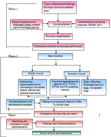
Chapter Two: Methodology
2.1 Methodology
The term “methodology” means a set of principle and way by which particular activity have been done. The nature of research methodology widely varies from subject to subject as well as availability of resources. A dictionary of social science observes that Methodology is the systematic and logical study of the principles guiding scientific investigation. So this study has also maintained a well defined methodology due to completion of this research. The phases, steps which have been taken for the completion of this study are described below.
Phase-I, involved conceptualization, develop theoretical framework and fixing goals and objectives and defining the scope of the study and understanding the planning proposals.
Phase-II, involved data and information collection. Data and information are collected from both primary and secondary sources.
Phase-III, involved analysis and tabulation of field data, interpretation of maps, identify the problems, comparison plan and reality and some recommendation for mitigate those problems.
Phase-IV, finally involves the preparation of the report.
The concept will be finalized after having an overall idea about the planning proposals of retention ponds in Dhaka city from the DMDP structure plan (1995-20015) with other related texts, reports, articles and conversation with the persons who are related in this field. The title and the possible extent also will be determined subsequently.
2.2 Literature Review
The related literature will be gathered to make an extensive study to understand the theoretical background and the real scope of the study.
Dhaka metropolitan development Plan (1995-2015) prepared by RAJUK demarked the flood retention pond, low land and wet land around Dhaka city which is obligatory to follow and maintain. But for lack of law enforcement, institutional capacity, corruption and influence of real estate companies RAJUK failed to preserve as per the proposal. Natural drainage system encroached, sometimes filled up by the people. It aggravated the water logging in the city especially poor drainage areas (Adri, 2006).
There are a number of major studies which have been drawn upon in preparing and formulating the recommendations contained in the DMDP structure plan. The most significant of these studies are the Dhaka master plan, prepared in 1959 and they provide several proposals and indications of management and preservation of natural drainage system of Dhaka. The Dhaka metropolitan area integrated urban development plan, prepared in 1981 and the FAP8A and FAP8B studies carried out in 1990-1991.the FAP 8A and FAP 8B proposals also includes these management and preservation of drainage system in the context of the Dhaka’s future growth options.
Dhaka Metropolitan Area Integrated Urban Development Plan (DMAIUDP Study), prepared in 1981, evolved from a series of reports and concerned with storm water drainage and flood protection. The ADB strongly recommended that further flood protection investment should await the outcome of a board multi-sectoral strategic study to evaluate metropolitan planning options. It remains a lucid statement of the urban development issues facing Dhaka.
FAP 8A
The Greater Dhaka protection Project (FAP-8A), funded by JICA, formulated a framework for comprehensive flood control and storm water drainage in the Dhaka metropolitan area, covering an area of 850 km2.
FAP 8B
The Dhaka Integrated Flood Protection project (FAP- 8B) for the western part of Greater Dhaka is under execution and funded by the ADB. It addresses the integration of flood protection works for Dhaka Metropolitan Area, covering an area of 260 km2, with other infrastructure and environmental improvement measures. FAP 8B Components include embankment strengthening, pumping stations, drains, slum/squatter area improvement, sanitation/ sewers, and solid waste management, as well as institutional and implementation recommendations.
In a journal Khan,N.I.(2001) in her article namely “Assessment of water logging conditions using integrated GIS and remote sensing techniques: a study of Dhaka mega city” has described the drainage condition of Dhaka city, pre urban natural drainage situation ,relationship between geomorphic settings and present water logging condition of Dhaka city.
In an article “Encroachment on Natural Canals and Low Land Causing Water Logging in Dhaka City: a case study on Begun Bari Khal” Mahmud, M.A. (2006) make an understanding of the necessity of natural drainage. The study would clearly identify the process by which the natural drainage system in the city is gradually disappearing. The study would help find out the problems associated with retaining the natural drains. The concerning issues of the study is to come up with a plan to recover and preserve those canals for sustainability of the city as per as water logging and urban environment.
A study on “Drainage Master Plan for Dhaka City and DND Area” of IWM and DWASA, review the Drainage Master plan of Dhaka city prepared by JICA. It analyses the documents and existing flood protection and drainage measures, drainage improvement plans for western Dhaka, eastern Dhaka and for DND area. It also identifies the institutional and management constraints of implementation of proposals.
A study named “Flood Management and Vulnerability of Dhaka City” done by Huq and Alam, 2003 described that after implementation of the flood control project in the Dhaka West, unplanned and uncontrolled expansion of urban area stretched rapidly toward the low-lying areas adjacent to the flood protection embankment. Land development through land filling processes in the low-lying areas is causing a drastic reduction in water storage areas.
Bari and Hasan, 2001 in their study “Effect of Urbanization on Storm Runoff Characteristics of Dhaka City” investigated the impact of land use changes due to urbanization on storm runoff characteristics in the eastern part of Dhaka City. They found that the volume of peak rate runoff increases with growth in urbanization. Most of the low lying lands, which once acted as retarding basin, have been filled up. Computed results show that runoff volume is increasing with increase in built-up area in Dhaka city.
Chowdhury, J. U. et al., 1998 in their study, “Measurement and Analysis of Rainfall Runoff in Selected Catchments of Dhaka City” shown from the analysis of rainfall data that the spatial variability is quite large. The aerial reduction factor is likely to be substantially lower than that used in the storm water drainage master plan for Dhaka City. Analysis of storm rainfall and runoff data indicates that the initial loss is much higher than those expected in cities in developing countries.
In the study ““Causes and Effects of Water Logging in Dhaka City”, Tawhid, K. G., 2004, describe the causes of the water logging in Dhaka city, and effect of water logging to the city life. In the study the writer also suggest some recommendation to improve the water logging situation of the Dhaka city.
Md. Khalequzzaman, in his article“Flood Control in Bangladesh through Best Management Practices” formulates solutions of flooding problems which requires a comprehensive understanding of the geologic settings of the region, and a better knowledge of hydrodynamic processes that are active in watersheds. Solutions to flooding problems can be achieved by adopting and exercising watershed-scale best management practices.
“A mouse GIS study of drainage in Dhaka city” of Rabbi, 2001 implies that the city drainage depends very much on the water levels of the peripheral river systems. Hence, standard draining by gravity may not always be possible. In order to facilitate and improve drainage it is considered to install drainage pumps at some of the FCD structures connecting to the rivers. Large reconstruction work has also been proposed. The MOUSE model has been selected for the modeling study.
Tauhidul Anwar Khan in his article “Flood Problems in the city of Dhaka and possible mitigatory measures” described about some factors of drainage efficiency of the city Operation of the sewage system, both storm water and domestic sewage and another is water levels in the peripheral rivers. Major factors responsible for Dhaka’s urban flooding and some mitigatory measures are also analyzed in his article.
Many articles of daily news papers are also collected and studied for the research.
2.3 Methods of Data Collection and Analysis
To fulfill the objective of the study both primary and secondary data and information are needed. All the necessary data and information has been collected from various sources.
2.3.1 Conceptualization and Secondary Data Collection
Text and document related to develop control, growth management and planning permission of RAJUK helped to develop theoretical framework of the research. An in-depth investigation has been performed into the recorded documents regarding drainage aspect from various offices. Ordinance, rules has been collected from WASA, RAJUK, DCC to understand the nature, functions, roles of concerned authorities in protecting natural canals, reservoirs. For the purpose of the present study, three different types of maps have been collected. The existing land use map has been collected from DDC and RAJUK. Population and size of the area is collected from BBS. The existing drainage layout map was also needed and this has been collected form Dhaka Water and Sewerage Authority (DWASA). The CS map collected from Directorate of Land Records and Survey. Rainfall data and the storm water and sewerage drainage system data were needed for the study. The rainfall data has been collected from Meteorological Department of Bangladesh (MDE) and the drainage data has been collected from Dhaka Water and Sewerage Authority (DWASA).Besides books, journals, internet facilities have been availed to prepare a solid foundation of the research.
2.3.2 Primary Data and Field Survey
Personal interview and direct field observation method were applied for the requirement of the study. To find out condition of the retention area, pumping station and inherent causes of drainage congestion of the study area and its associate problem on city life, the field survey was conducted with an informal interview of the authorities of different concerned organizations, experts and people living in different parts of the study area.
2.3.3 Data Analysis and Interpretation
All the data both spatial and non spatial collected from different sources has been analyzed separately. The spatial data has been analyzed by using some like Arc/view etc. and spatial data has been analyzed using by Geographic Information System (GIS), Adobe Photoshop and some other statistical computer software like, Microsoft Excel, etc. Finally the both types of analyzed data have been integrated and presented as maps, tables, and graphs and putted in the report.
2.4 Recommendation
The constraints behind the plan implementation would be identified and analyzed and a Comparison between plan and reality would be drawn in this study. On the basis of evaluation some prospective recommendation would be made with implementation procedure.
2.5 Report Writing and Presentation
Finally after compiling all the data, map and relevant information the report will be written and presented
Figure 2.1: Flow diagram of the methodology
Chapter Three: Description of the Study Area
3.1 General Discussions
The study area falls in the SPZ 5 and various characteristics of the study area is described below.
3.1.1 SPZ: 5- Mirpur and Pallabi
Mirpur Thana (Dhaka district) with an area of 53.58 sq km is bounded by Pallabi Thana on the north, Mohammadpur Thana on the south, Kafrul and Pallabi Thana on the east and Savar upazila on the west. Main River is Turag. Mirpur area is an extended part of the Madhupur garh created in the Pleistocene period (Banglapedia, 2004).
This zone can be considered as a planned area which is largely developed to cater to the needs of the low and medium income population who find their employment work in the Motijheel CBD or adjacent areas. It was developed partly to mitigate the housing need of the migrates from India immediately after partition of 1947.The housing Settlement Directorate (HSD) has developed a number of planned housing neighborhoods in this zone. Other important elements in the zone are the Botanical garden, Zoo, national Stadium no.2, national swimming pool, Indoor stadium, Dental College, Mirpur ceramic industry, sanitary ware factory, military academy, Mirpur cantonment, Mirpur shrine and Graveyard for Martyred Intellectuals. The planned areas of the zone are served by a well developed road hierarchy.
3.1.1.1 Major Issues and Problems
A substantial part of the zone (northwest and east along side ZIA) is low lying. However, new urbanization pressures may endanger the area reserved for a retention pond which is vital for the functioning of the FAP8B project recommendations. The vacant land available for urban development will need substantial land fill or social protection (safe embankments). The cantonment and ZIA restricted areas, which lack thoroughfare roads, from a physical impediment for development. There are very large slums in the zone, where basic services are in acute short supply and overall the zone severely suffers from shortage of utility services like water, electricity, sewerage etc.
3.1.1.2 Opportunities
The zone is served by open spaces at the metropolitan level. The ongoing DUIIP project would reduce the problems of water supply, sanitation etc in this SPZ. The proposed north Dhaka sewerage project with treatment works at Mirpur would provide improved sanitation to a substantial part of the area. The FAP8B address the drainage requirements to a significant extent in this area.
3.1.1.3 Actions Committed/Required
In this SPZ some measures would be taken to protect the designed retention pond areas and development of the ponds, together with the zoo and botanical garden into a metropolitan scale recreational area. Vacant land in the eastern periphery alongside the Zia international Airport could be used for low rise low income housing and a detailed plan is required in this respect. There are many small water bodies within the spontaneous areas. These fulfill local requirements for open spaces and measures are required to secure their retention /drainage function. Detailed area plans are needed for areas to be reclaimed under FAP-8B to secure proper urban environment and utility services in these areas.
3.2.1 SPZ 5
3.2.1.1 Description of the Study Area
The Wards no.2, 3,5,6,7 and 8 are the study area of SPZ 5.In figure 3.2 the study area is shown. The study area is bounded by Begum Rokeya Sarani on western side, the road from Mirpur 10 to Navy colony on southern side and Cantonment road on eastern side consisting of Mirpur section 10,11,12 13 and Pallabi, Rupnagar and Bhashantek. The most important features and land marks of this area are police Staff College, National Center for Special Education, homeopathic medical College and hospital, Navy Colony etc. Basically belonging to Pallabi Thana this area has planned as well as unplanned area. Mirpur section 10,11,12,13 and Pallabi, Rupnagar R/A are planned areas. The unplanned areas are Baighar Tek, Lalmati, Balurghat, Manikdi etc. the famed Bhasantek area where at present low income and slum housing is being constructed is situated in this SPZ. Mirpur Ceramic industry, Dental college, national Police college, national center for Special Education, BRTC bus depot etc. are located in this SPZ. This SPZ-5 has been catering the housing needs of the low and medium income group, working Motijheel C/A and various other parts of the city (RAJUK, 2008).
The study area is a built up area with mostly residential development except on the both side of western embankment along Turag River. A review of the existing land use pattern of this area shows that residential development is the most dominant land use.The prominent neighborhoods of the study area are: Mirpur cantonment, Mirpur section 1,2,6,7, Pallabi part-1 and extension, eastern housing, Rupnagar, Uttor Bishil,etc.
The main natural drainage canals of the study area are Bounia Khal, Abdullahpur Khal, Diabari Khal and Degun Khal. These canals are linked with the River Turag.
3.2.3 Description of the Planning Area
3.2.3.1 Administrative and Cadastral Boundaries
The area under Group C is broadly bounded from the north by the Tongi Khal, from the south by Buriganga River, from the east by locations 4, 10 and 11 and from the west by the Turag River. SPZ 5 falls in Group C’s jurisdiction.
3.2.3.2 Geophysical Situation (Geology, Hydrology, Soil)
On the north west of the built up city, there lies a vast low lying area. On the east of this low land ZIA international Airport and the Uttara Model Town are located. From the west and from the north this low land is bounded by the flood protection embankment and ZIA international Airport and on the North West, the land is moderately low where dispersed village settlements with many ponds have been developed.
3.2.3.3 Topography (Physical Form, Infrastructure, Land Use)
According to the survey data of Group-C, most of the area has an elevation of 6 to 10 meter. The highest elevation is seen in the northern part of Dhaka that is Mirpur, especially Pallabi area. Elevation reaches as high as 17 meter in this place. The slightest undulation is found in Mirpur area. Beside the highest, the lowest point is also located at Mirpur. Kallyanpur Jheel, Bounia and Western part of the airport are mostly low lying.
There are 585 km of drains in the study area out of which only 13.03 km are kutcha and the rest are pucca. Total area occupied by drains is 62.18 acres. In Dhaka city there are 881.02 km sewer line, 50,671 nos. of sewer connection, 29 nos. of sewer lifting station and 1 no. of sewer treatment plant provided and maintained by DWASA.
Not all the areas of Dhaka city are covered by sewer system network. The area like Mirpur, Pallabi, Shayampur are not included in sewer system network. Some times break down occur in sewer system causing suffering to the people of the area. This breakdown occurs due to sewer lines are not sufficient in length and width to take the load of the whole areas. Moreover, the blockage in the sewer lines at some points creates over flow of storm water drainage and causes break down of sewer line.
Dhaka city produces about 35 m.t. of solid waste everyday. About 85% of total collected wastes are transported to the dumping sites. Dhaka City Corporation is responsible for collection and management of solid waste. There is no sanitary landfill for solid waste management. Open dumping is only the practice here. The unhygienic management of solid waste is creating health risk to the local people (RAJUK, 2008).
3.3 Study Area in the Context of Drainage Zones of Dhaka City
The JICA study of 1987 (late updated in 1990), divided the Dhaka city area into 12 zones. As some retention pond and there catchments area falls in some area of zones I, J, and K. It has been found that western Dhaka can be divided into 16 drainage zones. While eastern Dhaka has three major drainage zones similar to FAP-8A Master plan study. A pumping plant is located at GoranChatbari.
Chapter Four: Theoretical Framework
4.1 Clarifying Terminologies
In this study several terms would be used in discussion. In theoretical framework the general definitions of the related terms are given.
4.1.1 Retention Area
Natural or man made depression usually reserved in urban area to retain the flood or rain water (Tawhid, 2006). It is an open body of water accumulating in a naturally occurring low area that has been designated in a structure plan, urban area plan or detailed area plan for the collection and temporary storage of storm water falling in a peak rainfall period for later discharge into receiving bodies of water through natural drainage or by pumping.
4.1.2 Retention Ponds
A retention pond is designed to hold a specific amount of water indefinitely. Usually the pond is designed to have drainage leading to another location when the water level gets above the pond capacity, but still maintains a certain capacity. These structures are designed to accommodate a specific amount of water. If the flow exceeds this amount, there is some kind of exit provided from the basin for the excess water.
A water retention pond, on the other hand, retains water all the time. The pond level may go up and down, but ordinarily the pond has some water in it. So if the pond is typically empty except during and shortly after rain or other precipitation, it is a detention pond. If the pond always has water in it, then it is a retention pond. Retention pond, sometimes called a retention basin, is a type of constructed wetland that is used to contain storm or rain runoff. A retention basin provides an area to hold water from a small surrounding drainage area that would otherwise flow into other areas. The water remains in the local area that it was deposited in.
4.1.3 Drainage
The Delhi workshop defined drainage as “the removable of unwanted water from human settlement.” Such unwanted water can include storm runoff and flood water from seasonal rains, marsh or pond water in low lying areas, and the used domestic water (sullage) of the community. All these constituents have a potential impact on health and well-being (Ahmed, 2000).So drainage is important in itself as utility service as well as in natural considerations.
4.1.3.1 Need of Drainage
Drainage systems are needed in developed urban areas because of the interaction between human activity and the natural water cycle. This interaction has two main forms: the abstraction of water from the natural cycle to provide a water supply for human life and the covering of land with impermeable surfaces that divert rainwater away from the local natural system of drainage. These two types of interaction give rise to two types of water that require drainage (Sharifuzzaman, 2006).
The first type, wastewater, is water that has been supplied to support life, maintain a standard of living and satisfy the needs of industry. After neither use, if it is not drained properly, it could cause pollution and create health risks. The second type of water requiring drainage is rainwater (or water resulting from any form of precipitation) that has fallen on a built-up area. If storm water is not drained properly, it would cause inconvenience, drainage, flooding and further health risks. It contains some pollutants, originating from rain, the air or the catchments surface.
When rainfalls on to undeveloped land, most of the water will soak into the topsoil and slowly migrate through the soil to the nearest watercourses or groundwater. A small proportion of the rainfall – usually 15 to 20 per cent – becomes direct surface runoff that usually drains into watercourses slowly because the ground surface is rough (e.g. because of vegetation). This means that the effects of rainfall are spread out over a period of several hours. When catchments are developed, the proportion of the land covered by impervious surface (roads, parking areas, roofs, driveways and pavements) will increase, preventing the natural infiltration of rainfall into the ground (Tawhid, 2004).
Volume and rates of runoff both increase significantly after development. It also means that drainage is needed to reduce flood risk within the developed areas.
4.1.4 Natural Drainage System
A natural drainage system is a branched network of stream channels and adjacent land slopes, bounded by a drainage network and converging into a single channel at the outlet developed through natural process. It is presented almost in every part of the country. The natural drainage system in the greater Dhaka city comprises of several retention areas and khals (channels), which are linked to the surrounding rivers (Tawhid, 2004).
4.1.5 Lowlands and Wetlands
Lowlands are the storm water retention areas of the city and the wetlands are the major source of ground water recharge.
4.1.6 Flood plain
Any land area susceptible to being regularly and/or seasonally inundated (DMDP, 1995)
4.1.7 Flood
A general and temporary condition of partial or complete inundation of normally dry land areas from the overflow of inland, river of tidal water resulting from any source, or the unusual and rapid accumulation surface water runoff from any source (RAJUK,1997b). Flooding in Dhaka Metropolitan area can be classified into two types. One results from high water levels of peripheral river systems, thus rendering any natural drainage impossible. Another is caused by high intensity storm rainfall runoff in the city area, which causes flooding also in situations where natural drainage might be possible.
River floods generally take place in the low laying fringe areas outside the protective embankments once in every five to ten years (K. Rabbi et. al, 2001). A number of severe flood have struck Dhaka since its early days and its vulnerability is reflected in the Buriganga River’s floods embankments first built in 1864. Severe floods in Greater Dhaka City area mainly caused by spill over from surrounding rivers flowing to and from the major rivers of the country. In recent history, Greater Dhaka City has experienced major floods in 1954, 1955, 1970, 1974, 1980, 1987, 1988, and 1998 due to the over flow of surrounding rivers (Huq and Alam, 2003). Among these, the 1988 and 1998 floods were catastrophic. Poor drainage capacities of the existing khals caused long flood duration in inland areas and aggravated the flood damage.
4.1.8 Mega City
A metropolitan area having population more than 5.0 million is termed as mega city (Population Census, 2001). According to population census 2001, Dhaka is the only mega city of the country.
4.1.9 Encroachment
Encroachment of natural drainage system is a common practice in Bangladesh. Most of the natural drainages of Dhaka City disappeared or are in way to lose their existence due to illegal encroachment. According to 76 per cent of respondents, encroachment on the rivers and khals/drains through unauthorized construction and solid waste, and the lack of regulations to prevent encroachments making the drain ineffective to drain out the run off.
The filling-up of vast areas in Ashulia, Banashree, Aftabnagar, Meradia,Baunia, Badda, Amin Bazar and Hatirjheel, known as water catchments, increased the hazards of water logging that swamped much of the city. The Dhaka Master Plan has clearly marked these areas for flood retention and the Wetland Conservation Act, 2000 bars land development in water bodies. According to the Conservation Act, no one has the right to develop wetlands, flood flow zones or catchments. But the developers and land owners have occupied and filled the areas without considering the flood vulnerability in the city.
4.1.10 Khal
Canals passes through Dhaka city that are created naturally and used as drainage channel to drain out the flood as well as rain water of the city to the surrounding outfall rivers.
4.1.11 RAJUK
Rajdhani Unnayan Kartripakkha (Capital Development Authority) is the planning and development management authority of Dhaka mega city. It is also responsible for building control. It was first created in 1955 as DIT and bestowed with the responsibility of implementing Dhaka’s first Master Plan. As present implementing the DMDP-a twenty years plan consisting of different components for the development and growth of Dhaka- is RAJUK’s major responsibility. RAJUK’s geographical area now covers 1528 sq. km. However, the power of RAJUK is controlling the elements of urban growth is very limited because of the fragmented development management system (RAJUK, 1997b).
4.1.12 Infiltration
Infiltration is the water which enters the sewers from the ground through leaks or faulty joints.
4.1.13 CS Map
Cadastral survey map prepared for all over Bangladesh based on the survey from 1912 to 1915.people use these maps to find location and actual area of land in the field (RAJUK, 1997b)
4.1.14 RS map
Revenue survey map prepared for different part of Bangladesh based on the survey from 1966 to collect revenue by the Government (RAJUK, 1997b)
4.1.15 Water Logging
Flooding in built up areas caused by rainfall, where water remains stagnant for long time due to lack of proper drainage system and creates many adverse impact on daily life.
4.1.16 Developer
A land owner (either public or private) or any person with written authorization from the landowner who intends to improve or to construct buildings or carry out other forms of development actions upon a zoning or portion of a zoning plot (RAJUK, 1997b)
4.1.17 Development
The carrying out of any construction, building, cutting or filling of land, the carrying out of building, engineering, mining or other operations, on over or under land or the making of any material change in the use of land, water or building and the subdivision of land (RAJUK,1997b).
4.1.18 SPZ
Geographic unit of the metropolitan area as is laid down in the Urban Area Plan. There are 19 SPZ. Some of these have been further subdivided into sub zones so that the actual total becomes 26. Master Plan particularly identified specific features of the each SPZs, and demarcated few rivers, Khals, small water bodies/retention ponds, lake and open spaces and obliged legally to protect them from illegal developments. Specifically fourteen SPZs are identified mentioning its mouzas as flood flow zones, and clearly prohibited earth filling without due permission from the concerned authority. However, the study area is falls into the SPZ-5.
4.1.19 DMDP
Dhaka Metropolitan Development Plan, a Package of Structure Plan Master Plan and Detailed Area Plan were prepared to develop Dhaka City in a planned way for 20 years (1995-2015). The project was one of UNDP’s aided projects implemented in cooperation with UNCHS/HABITAT in Dhaka.
4.1.20 Urban Area Plan
This plan provides an interim mid term strategy for the 10 years to 2005 and covers for the development Drainage and Flood Protection, Sewerage, Sanitation and Solid Waste management of urban areas within metro Dhaka management area.
4.1.21 Structure Plan
This plan provides a long term strategy to the year 2015 for the development of Dhaka metropolitan region. It identifies the magnitude and direction of growth and recommends spatial and sectoral policies over the long term for the DMDP area of control of about 590 square miles.
4.1.22 DAP
These plans provide more detailed planning proposals for specific sub-areas of Dhaka. However they do not initially cover the entire Dhaka structure Plan Area (590 Sq miles). While all sub-areas will eventually require a DAP; only priority areas will be dealt with initially. The detailed area plan consists of report and maps with supporting documents. They may include the area of one or more SPZ or parts of several SPZs depending on circumstances.
4.1.23 Flood Flow and Sub Flood Zones
A river in its flow regime maintains a width in which the flood flows occur during flooding time. The rivers and flood plains play an important role in both the ecology and economy of the region. Land development within the designated flood plain areas requires control to avoid obstruction to flood flow; whish might otherwise result in adverse hydraulic effects like rise of flood water levels, and changes in flow direction.Main flood flow zone is the cross sectional area of a river that carries the dominant flood flow whereas; sub-flood flow zone is the zone that carries the less frequent and high magnitude flood in a season..
4.2 Hydrologic Design Criteria in Master Plan
4.2.1 Rainfall and Runoff
During rainfall, a certain portion of the rain water is lost to the atmosphere through evaporation and evapo-transpiration and a certain portion which infiltrates into the soil lost to the ground water reservoir. Yet a certain portion finds its way into the numerous small or large depressions. The remaining water flows overland towards the stream channel and is called the surface.
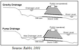
In response to the request of the Government of Bangladesh (GoB), the Government of Japan agreed to conduct a study on greater Dhaka Flood Protection within the framework of technical cooperation between Japan and Bangladesh. Need for this study was felt when Dhaka City suffered from an unprecedented flood in 1988, which was caused by floodwater carried by surrounding rivers. The Japan International Cooperation Agency (JICA), the official agency responsible for the implementation of technical cooperation program, was assigned to undertake the study. The JICA study team commenced this study in 1990. One of the objectives was to carry out a Master Plan study on comprehensive flood control and storm water drainage for Dhaka Metropolitan area. The operational strategy of the gates and pumps is illustrated in figure 4. 1.
Figure 4.1: Illustration of The Operational Strategy of The Gates and Pumps
4.3 Capacities and Gravity of Drainage System of Dhaka City
The reason of long lasting water logging situation in the city area is owing to inadequate drainage capacity that is small pipe and inappropriate lining of pipe. Absence of adequate roadside drains, lack of enough inlets to the secondary drains to carry storm water and outlet to the receiving water bodies and natural drains helps in creating drainage congestion.
Dhaka City has an area of 360 square kilometers and storm sewage pipes runs only for 210 kilometers having diameters ranging between 450 to 3000 mm. The city has box culverts running for 7 kilometers with sizes between2.5 m X 3.4 m to 6 m X 4.1 m. underground and surface drains cover 1100 kilometers and 22 open canals runs for 60 kilometers having width of 10 to 30 m (JICA, 1991).
But the existing drainage system is not capable to drain out the storm water of Dhaka City during the rainy season (May to October) having average rainfall of 304 mm, 267 mm, 262 mm and 231 mm in the year of 2000, 2001, 2002, and 2003 respectively (BMD, 2003). Experts say the city’s drains have the capacity of draining out 10 to 15 mm of rain water per hour and that’s why the drains overflow when its rain heavily.
The present storm water drainage network under Dhaka WASA covers and area of approximately 140 sq. km. important components of drainage network are- 22 open canals has width of 10 to 30 m and total length of approximately 65 km.; 185 km. of underground pipes having diameter ranging between 450 to 3000 mm.; 6.5 km. of box culvert of sizes between 2.5 m * 3.4 m to 6 m * 4.1 m and 2 storm water-pumping stations, with capacity of 9.6 m /s and 10 m /s at Narinda and Kallyanpur respectively.
Recently DCC has constructed one storm-water pumping station, having capacity of 22 cum/s at the confluence of river Buriganga and Dholai khal. Dhaka WASA has taken over the operation and maintenance of the pumping station. Moreover, DCC have constructed and maintains at least 130 km small diameter underground drains and approximately 1200 km surface drains, which carry storm water to the main sewer lines. RAJUK also constructs roadside underground drainage lines during the construction of new roads, which will increase the drainage network of the city.
Chapter Five: Existing Drainage Condition of Dhaka City and the Study Area
5.1 Storm Sewer and Natural Khal of Dhaka City
5.1.1 Natural Drainage System
Natural water bodies play an important role in the drainage system of any area. The water body performs together with the functions of water reservoir and the discharge sites of artificial drains. The natural drainage system can be divided into two types-Storage area and Channel.
5.1.2 Storage Area
There are more than 40 khals in greater Dhaka city comprising these major Khal systems:
• Degun-Ibrahimpur-Kallyanpur Khal system which drains to Turag River.
• Dhanmondi-paribagh-Gulshan-banani-mahakhali-Begunbari khal system
which drains to Balu River.
• Segunbagicha-Gerani-Dholai khal system which drains to Balu and Buriganga River.
Approximately five-sixth of the city areas are drained through these channels to the surrounding rivers. The catchments area of the channels varies from 6 to 40 sq. km.
Table 5.1: Characteristics of major khals in Dhaka city
Name of the khals Length(km) Catchments area(Sq. km)
Dholai khal 4.0 16.8
Gerani khal 3.4 6.7
Segunbagicha khal 3.5 8.3
Begunbari khal 6.5 37.7
Total 17.4 69.5
Source: JICA, 1991
There are primary, secondary and tertiary drainage khals in the Dhaka city. Primary khals in Dhaka west area are: 1.Abdullahpur Khal, 2.Diabari Khal, 3.Digun Khal, 4. Baunia Khal, 5.Ibrahimpur Khal and branch Khal, 6.Mirpur Khal, 7.Kallyanpur Khal, 8.Ramchandrapur Khal, 9.Katasur Khal, 10.Dholai Khal and Narinda Khal, 11.Segunbaghica Khal, 12.Mugda Khal, 13.Paribagh Khal, 14.Motijhees and Begunbari Khal, 15.Gulshan Khal.
5.1.3 Natural Storage and Reservoirs of Storm Water
The city rainfall-runoff is accumulated in the retention areas and discharge to the surrounding rivers through khals. There are many water storage areas such as lakes, ponds, and low laying lands. The natural storage and reservoirs are
1.Dhanmoni Lake, 2.Gulshan Lake, and 3.Banani Lake, and 4.Ramna Lake, 5.Retention ponds for GoranChatbari, kallayanpur, Narinda and Rampura pump stations. The above mentioned lakes and retention ponds are required improvement and development.
The storm runoff from Dhaka city is discharged to the surrounding rivers, which are distributaries from the river Brahmputra River .The stage of these rivers generally, remains high during monsoon. As a result, the drainage system of Dhaka city is under the influence of backwater effect from surrounding rivers. Consequently the flow velocity in storm sewers and drainage channels remain very slow for several days when flood wave passes through the surrounding rivers. Fortunately, the lakes and low-lying areas provide storage space for storm water. These large retention areas save Dhaka city from flooding during heavy storms. Gradual reduction in retention areas because of human activities causes increasing flood problem in Dhaka city (Tawhid, 2004).
In the past the present Mirpur area was full of pond, lake, low land etc. This storage was play important role of the drainage system of the Mirpur area. Now a day SPZ 5 is a built up area and turned into a residential and institutional area for the improved road network. In Mirpur and Pallabi area most of the low land, pond etc. are filed up and developed to meet the increasing demand for housing. At present in the study area of Mirpur and Pallabi have few low land, pond. The area encompassing Kallyanpur Retention Ponds, group of retention ponds near Zoo including the areas of Adabor, should be kept for wetland functions.
Due to rapid expansion of the city, the natural drainage system was interfered with in some places and in some places destroyed. In late 60’s a master plan on city drainage and flood control was drawn up and in early 90’s a master plan was formulated under flood action plan (FAP8A). A long time elapsed between the preparation of plan & its implementation, as a result the drainage scenario had changed quite significantly, change in topography and land use and interventions (Islam, 2006).
Figure 5.1: Natural drainage system of Dhaka in the year 1968
The study area is bounded by some natural canals such as Degun khal, Housing Khal
, Bounia Khal, Abdullapur Khal, Diabari Khal, Ibrahimpur Khal and Baishteki Khal. The canals are linked with each other but the drainage lines are not well networked with the natural canals. If the drainage lines would be well networked with these canals then the drainage and water logging problem would be solved. The length of natural drainage canals of the study area are:
Bounia Khal : 8.83 km
Abdullahpur Khal : 5.63 km
Diabari Khal : 4.34 km
Degun Khal : 4.59 km
These drainage canals have to be protected from encroachment and well linked with the retention ponds and drainage network.
5.1.4 Artificial Drainage System
5.1.4.1 Concrete Pipes
They form the most important part of the present drainage system. Existing storm sewer network has 60 miles of concrete pipes (WASA, 2006). There are about 4000 manholes in the network (WASA, 2008).Storm water is led to the main sewer network through numerous catch pits. There are approximately six thousand catch pits that collect storm water from specific areas and deposited to the main sewer lines.
In fact, Water Supply and Sewerage Authority (WASA) has to deal with 150 square km of the capital, less than half the actual city size, and it requires around 350km of rainwater drainage pipes. It, however, only has 265km of drainage pipes. Inadequate and faulty drainage network, filling up of drainage canals and lack of proper cleaning of drains are the main reasons behind water logging in the capital (BangladeshNews.com, 2008).About 90km more rainwater drainage lines are needed at different areas of the city to strengthen the drainage system. The width of the existing pipes should also be increased. Dhaka WASA had 135km of drainage lines in 1990 and it has been extended to 265km. However, the population of the capital city was 68.44 lakh in 1991 and now it is 1.20 crore. The number of houses in the city has more than doubled, according to WASA and Rajdhani Unnayan Kartripakkha (Rajuk).Most parts of Uttara, Gulshan, Banani, Badda, Manda, and large sections of Khilgaon, Bashabo and Rampura are still outside the WASA’s drainage system coverage(BangladeshNews.com, 2008). In places where there is no drainage network of Dhaka WASA, the Dhaka City Corporation (DCC) covers the area with drainage pipes or surface drains.
5.1.4.2 Box Culvert
Construction of box culvert is some sort of newly implemented technique for the improvement of city drainage system. These are mainly proposed by the greater Dhaka Flood Control Project (GDFCP) after the 1988 flood. Their construction is still continuing on. Box culverts are square shaped structure having the biggest x-section (6.3 sq m) of present time for Dhaka city drainage system. Slope used is about 2:1 (WASA, 2008).To release mark the accumulated sludge inside, it has instant flushing system. To prevent accumulation of toxic gases inside, it has well equipped ventilation system after sufficient interval too.
5.1.4.3 Surface Drains
Surface drainage is the removal of excess water from the surface of the road. This is normally at the side of the road accomplished by shallow ditches, also called open drains. The roads are sloped toward the surface drain and the surface drain is connected with the storm drainage network. The storm water and other water that fall on roads are run off to the surface drain and descent to the drain. There are numerous surface drains in the city forming a very complex labyrinth.
5.1.4.4 Sewerage Drainage
DWASA is responsible for the Sewerage drainage of Dhaka city. The operation and maintenance of the sewerage drainage system is organized by the P & D sewerage of DWASA. For the better management of the city drainage system DWASA divided the whole sewerage drainage system into in to six different zones. Important components of sewerage drainage network are briefly summarized below:
631 km of underground Sewerage Line
Sewer Connection (number) 45,325
Sewage Lift Station (number) 23
1 Sewage Treatment Plant at Pagla.
(Source: DWASA, 2006)
5.2 Existing Flood Proofing Structures
The Tongi-Khilkhet-Rampura-Malibagh-Khilgaon-Saidabad road (Pragati Sarani-Atish Dipankar road) separates Dhaka city from eastern low lying areas. The natural drainage slope of eastern part of Dhaka city is towards east. Rainfall runoff and wastewater is drained through a numbers of drainage as well as flood proofing structures (FS) towards eastern direction and which ultimately falls into the Balu River. These flood proofing structures are very important to control flood water from incursion in the western Dhaka from the east (IWM, 2006). Figure 5.4 shows the existing flood proofing structures of Dhaka city.
5.3 Drainage Pattern of the Study Area
5.3.1 Channels of Natural Canals
Drainage is very important aspect for keeping the urban environment free from pollution and health hazards. Healthy atmosphere is pre-requisite for healthy living and healthy life. Drainage in the built up areas can be provided by network of drains. There should be sufficient tertiary, secondary and primary drains in city area that can carry storm water generated by rain. As rainfall in Dhaka is comparatively high the drain density needs to be also high. Rainfall in Dhaka on the average 2000 mm per annum and 70 percent of this rain comes from April to September. The study area of Mirpur have pucca household and Mohalla drains. Some of them are connected to natural khals of adjacent areas. Mirpur area suffers from drainage congestion during and soon after heavy rainfall.
Further to north of Dhaka city, Baunia and Digun areas are drained by Baunia and Digun khal of the study area. All discharges from kallayanpur Khal, Mirpur Khal, Ibrahimpur, Baunia and Digun khal falls in the Turag River. Abdullapur khal provides storm water drainage to the new airport, Faidabad and Abdullahpur areas discharges to Tongi khal at Abdullapur. Diabari khal and branches provide storm water drainage to Dohar, Nalbagh and Diabari areas and discharges to Turag River (IWM, 2006). It is as important as urban area drains to keep the drainage khals active and free from obstruction to flow and unauthorized occupation. Regular maintenance and re-excavation at certain intervals will keep the khals in good performance conditions and alive and will reduce intercity of flooding.
5.3.2 Drainage Zones of the Study Area
The western Dhaka is protected from flood by embankment in the north and west along the banks of Tongi Khal-Turag and Buriganga rivers. A stretch of around 5.75 km in the south is protected by floodwalls. Gravity drainage of the protected area occurs through 105 culverts and sluices. When the surrounding river levels are higher than the inside water level, drainage is executed by operating 3 permanent pumping plants at GoranChatbari, Kallayanpur and Dholai khal outfall (IWM, 2006). In addition to these permanent pumping plant, make shift (temporary) pumps are mobilized, if required, to pump out excess water from the protected area. The study area falls in the GoranChatbari drainage zone of DWASA.
GoranChatbari
This Zone lies on the left bank of Turag River. The total area is 53.87 sq km, mainly covering western part of Uttara, Mirpur, Dhaka Cantonment, Ibrahimpur, Kajipara and Sewrapara. The main drainage channels are Ibrahimpur Khal, Baunia Khal, Abdullahpur khal, Diabari Khal and Digun khal. A pumping plant is located at GoranChatbari with capacity of 22 cusecs. An 8-vent (1.52m *1.8m) sluice is located along with the pumping plant. Retention pond area for the GoranChatbari is around 274 hectares. The lowest and the highest land levels are 1.46 m PWD and 15.95 m PWD respectively.
Retention pond area at GoranChatbari Land filling at the study area
Pump station
Rapid housing development at the Pumps of GoranChatbari Pump station
Study area
5.4 Flood Control Function of the GoranChatbari Regulator
General information of the largest pump station of Dhaka-GoranChatbari pump station
• Diameter : 1.8 m
• 3 pumps and 3 pipes
• Running time: 10/12 hour, from 9am to 5 pm, if rains heavily then the pump runs for 3 or 4 days continuously. Normally the pump is running from the end of May to the end of November.
• Capacity: 7.33 cusec/ 7330 liter/s
• Motor capacity: 800 kilowatt
• Catchments areas: Mirpur, Abdullahpur, Cantonment, Manikdi, Balughat, Vasantek, Solahati.
• Retention area: 274 hectare
• Number of Sluice gate : 8 (2 sluice gate of Diabari is out of work)
Sluice gate ———————— Vent
1. Diabari ————————- 2
2. Goran (eastern housing) ——– 8
3. Kamarpara ———————— 4
4. Cantonment———————— 2
5. Rustampur ———————— 2
• Type of the pump: Vertical shaped axial flow pump
• Discharge : 258.66 cu ft/s or each pump 7.33 cum/s
• Total head: 6.80 m
• Pump speed: 296 RPM
• Motor speed : 296 RPM
• Voltage: 6.6 KVM
• Motor type : vertical squirrel indicator motor
• 3 phase motor: 6.6 volt each phase
• Frequency : 50 Hz
Output: 800 kw
Pole no: 6
• Rotation direction clockwise.
• Auxiliary pump: 2 cooling system,2 warm pump,2 deep tube well for raw water pump,2 cooling tower in front of pump and 3 trash rack in front of 3 pump.
• Tank diameter (delivery pump): 1800 mm
• Transformer capacity : 9 MVA
• Substation: 6.6 power substation
5.5 Solid Waste Deposition Condition of the Study Area
At present total solid waste generation in 90 wards of Dhaka city is around 3200 tons per day which will reach 4624 tons per day by the year 2015. This is a huge problem, but the arrangement for proper handling of the solid wastes by DCC in inadequate (Tawhid, 2004).in many areas of Dhaka city waste is thrown into the road or into the roadside drain. So it becomes blocked and the drainage network is disturbed. In the study area the over all waste management system is good. All the garbage of the area is gather in some fixed point situated in side of the road. From this point there is a proper arrangement of shift the waste away by Dhaka City Corporation. In some location of Mirpur, solid waste is disposed in the storm sewer which blocked and disturbs the whole drainage system.
5.6 Water Logging Problem in Dhaka City
5.6.1 History of Flood
Present greater Dhaka city experiences high magnitude flood almost in every ten years 2007, 1997, and 1988 floods for example submerged about 40 and 70 percent defined greater Dhaka city areas of 260 sq km (64832 acres) of which 136 sq km in west and 124 sq km in east. During 1988 flood of 70 years return period vast areas of Bangladesh including Dhaka city was flooded by flood waters of Tongi Khal, Balu, Turag, Buriganga and Sitalakkhya rivers. These rivers are distributaries of Brahmaputra, Jamuna, Gangas and meghna rivers carrying water from India, Nepal, Bhutan and other neighboring countries. The depth of this flood was higher than the normal flood by 1.5 m and its duration was more than 4 weeks. As a result many posh areas of Dhaka city including diplomatic zones in Gulshan and Baridhara; Mirpur, Mohammadpur, Banani, Tejgaon and Dhanmondi etc. were submerged to depths ranging from 0.3 m to over 4.5 m and about 2.5 million of the city were directly affected by the flood (IWM, 2006). The loss of property values like building, housing, school, college, university business and commercial areas and industries roads etc. were very high. In the wake of the 1988 flood, the government of the peoples Republic of Bangladesh constituted a committee in October 1988 known as Flood Action Flood (FAP) for flood protection and drainage of the greater Dhaka city to investigate the causes of such flood and recommend solutions.
5.6.2 Urban Flooding & Water Logging
Water logging in urban areas is an inevitable problem for many cities in Asia. In Bangladesh, Dhaka has serious problems related to water logging. During high water level in the peripheral rivers, all regulators are closed. Heavy rainfall, waste water from house holds & industries and septic waste accumulated in wetlands and Khals. Due to insufficient low lift pump capacity water level rises inside causes urban flooding in low laying areas in the western part of Dhaka city. (Islam, 2006).Due to encroachment, earth filling, deposition of city garbage in natural canals & lakes and construction of building, roads etc. in an unplanned & uncontrolled way, water logging becomes a common phenomenon during monsoon. Moderate rainfall causes also serious water logging in some areas which creates environmental & health hazards.
5.6.3 Flooding: Dhaka City West Area
This area is generally flooded by the ingress of flood water from north, west and south sides by Bangsi, Dhaleswari, Tongi Khal, Turag and Buriganga rivers. During the flood the river water stage of these rivers become so high that flood water from river first overflows to lowlands areas. Afterwards as low areas are filled up, flood water start flowing over high and higher lands. as soon as flood level of rivers further up, flood water flows over existing roads, bunds and starts entering city areas and submerges roads and lower parts of buildings.
1988 flood entered Dhaka city west area from Tongi, Mirpur, Mohammadpur, Dhanmondi, Hazaribag areas. Most of Tongi, Mirpur, Mohammadpur, Hazaribag areas, Dhanmondi west were flooded to depths from 0.3 m to 1.5 m in built up areas and neighboring low areas to depths upto 4.5 m. The duration of flood was about 4 weeks. Sometimes flood also occurs due to back water flow of these rivers in these areas of west Dhaka. In case of backwater flow flood, the ingress of flood starts from lower reaches to upper reaches of the rivers.
1988 flood over spilled the Dhaka west area and engulfed also the Dhaka east area from North West to south east. Thus both areas were equally affected by this flood. However, 1997 and 2007 floods were different in the sense that these floods were more intense in the Dhaka east area. Dhaka west area was safe because of protection works done in 1991 to 2000.
5. 6.4 Water Logging Scenario of the Study Area
Different city areas including Pallabi, Mirpur-10, and Kazipara, Shewrapara, Bijay Sharani, Mohammadpur and many parts in old Town of Dhaka go under knee to waist-deep water due to rain every year. Water logging problem is frequent in Pallabi and Mirpur sector 12 and 11. The area is served by surface drains of Dhaka City Corporation. These drains have insufficient conveyance capacity to drain even a moderate rainfall. Extensive water logging is also experienced in Kajipara, Shewrapara and Mirpur section 1, 2,6,10 and 13. The problem at Mirpur 10 is compounded by very steep topography draining an area of around 2 sq. km very quickly towards the traffic island. There is insufficient number of catch pits is the area which causes the storm water to flow sluggishly into the storm water drains, causing large scale water logging. The same phenomenon is also observed near Sony cinema hall in section 2.
Dhaka WASA’s superintending engineer (drainage circle) Md Zahirul Haque said, ‘There is no cause to be worried about water-logging in the city. The WASA has now the capacity to prevent water logging caused by normal rain fall. But we have nothing to do when abnormal rain occurs.’ Our drainage system has the capacity to drain out maximum rainfall of 10 millimeters in an hour, he said (New Age, 2007).But in reality there occurs severe water logging problem in rainy season due to inadequate drainage facilities in these areas, congestion of drainage system and no connection of drainage lines with the adjacent water retention areas in some ward of Mirpur.
Eastern Housing Project in Pallabi and its adjacent areas have been facing water logging as Diabari canal was partially filled by different real estate developers. The canal used to carry rain water to GoranChatbari pump house to be pumped out, said a WASA official. Encroachment on the canals has been causing water logging in Mirpur areas, while clogging of the main sewerage line of the areas has worsened the situation, the official said. Box culverts, which were constructed on different canals or water bodies, also remain clogged for lack of cleaning, contributing to the problem, monitoring of storm drains and the box culverts is also necessary to curb the debilitating water logging that plagues the city every monsoon.
Chapter Six: Legal Aspect Analysis
6.1 Review of Past Plans and Policies on Urban Storm Water Drainage
Under the present legal framework there are number of rules, laws as well as acts which are used to prevent land grabbing and encroachment into natural drainage system. Though they are not always being practiced but must be made an integral part of the process of getting any legal clearance of development permission.
6.1.1 Historical Overview
The Dhaka Master plan, submitted in 1959, covered the then Dhaka Improvement Trust (DIT) area covering roughly 220 sq miles, with a population slightly exceeding 1 million. Of this population, approximately 5755,000 were in Dhaka city (IWM, 2006).The Dhaka master plan assumed an average annual population increase of 1.75%.The Dhaka-Mirpur-Tongi (1978) population was estimated to be 900,000.The Dhaka master plan provided for major expansion areas at Mirpur, Tongi and Gulshan/Banani/Badda and proposed large scale reclamation at Keranigonj, Postogola and part of the DND triangle. It was estimated that these areas would accommodate a population of 250,000 between 1958 and 1978 (IWM, 2006).The Dhaka master plan has clearly marked and reserved 12 % of areas for flood retention. A number of the Dhaka master plan’s recommendations were followed and it still remains the legal basis for controlling development in areas covered by the Dhaka master plan.
The first full scale study on flood protection and internal drainage of Dhaka city was undertaken by the department of public Health Engineering (DPHE) in 1968, and a master plan was prepared. This plan covering an area of 75 sq km included construction of an embankment around the city, pumps stations and other internal drainage facilities (IWM, 2006).However, the plan did not receive the final approval. As a follow up of the above master plan, BWDB prepared a detailed plan covering an area of 144 sq.km. DPHE also prepared a separate plan for the internal drainage system submitted it to the government in 1976 (IWM, 2006).
However, another project of preparing a “Crash programme for removing water logging from Dhaka city” was prepared a plan in 1976 by DPHE that was implemented up to June 1980.In 1978; DPHE reviewed the 1968 master plan and prepared a plan of flood control and drainage works covering 144sq.km of Dhaka city but the plan was not accepted (IWM, 2006).
In 1981, a study on “Dhaka metropolitan area integrated urban development project” was completed with assistance from ADB and UNDP. The study area covered 256sq.km.however, no detailed flood control and drainage plan was proposed in the study. In 1980, following the “crash programme”, another drainage plan, namely “interim scheme for removing water logging within Dhaka metropolis” was approved and it was completed in June 1983 (IWM, 2006).
Moreover, in 1985,the “Revised crash programme for construction of storm water drainage in water logged area of Dhaka metropolis” was prepared by DPHE, which was continuing at the time of finalization of report of another comprehensive study, namely “study on storm water drainage system improvement project in Dhaka city” being carried out JICA (JICA,1987).
Though there was a preparation of plans for the storm water drainage system and flood protection, very few of them were implemented by these years. For this reasons from the earlier years the protection of flood retention ponds becomes an urgent for the city.
6.1.2 Review of Dhaka Integrated Flood Protection Project
In 1987 and 1988, Bangladesh experienced two of the most severe floods on record. Soon after the floods, various studies were conducted by different agencies, countries and the government of Bangladesh. Several action plans were proposed. The World Bank coordinated the studies and framed a flood Action plan (FAP) with 26 components as the initial stage for the development of a long term comprehensive system of flood control and drainage works. In response to the request of the government of Bangladesh, the government of Japan decided to conduct the study on greater Dhaka protection project (study in Dhaka metropolitan area) of Bangladesh (FAP 8A) within the general framework of technical cooperation between Japan and Bangladesh. The ADB decided to finance “Dhaka city integrated flood protection project” (FAP 8B) (IWM, 2006).
6.1.2.1 FAP 8A (JICA, 1991)
In FAP 8A project, major drainage facilities, such as pumping station with retarding ponds, sluice gates and khals, for the future development areas, Zoning of khals and retarding pond areas should provided and preserved.
6.1.2.2 FAP 8B
There are two parts in the phased programme in FAP 8B: part A-Flood protection, and part B-Drainage. Gate control structures at each of the 13 drainage channels crossings would be constructed for flood protection. In FAP 8B various drainage improvement programme was undertaken to eliminate the drainage congestion and regular local flooding of the city.
6.1.3 Drainage System Improvement Projects
The drainage improvement project study area was around 137 sq km, which was divided into 10 drainage zones. Various drainage improvement projects was undertaken at that time,such as Dholai khal Rehabilitation and Area Development projects, Greater Dhaka flood control and drainage project and Khal improvement project. Two new pump stations with total capacity of 24.5 cum/s and two regulating ponds with a total area of 242 ha with total storage capacity of 2.59 million with new sluice gates were proposed for construction in this project.
In this project no provision of the 14 drainage pipe trunks was recommended, only the installation of sluiced gates at the outlets to the Buriganga and Turag rivers was recommended. The drainage Zones were prioritized by the area’s rapid urbanization and serious damage it suffered in the 1988 flood.
6.2 Review of DMDP Master Plan (1995-2015) in Context of Study Area
In 1997, RAJUK published the plan consisting of a planning horizon of 20 years (1995-2010).The plan was subsequently approved by the Gob. The Master Plan of the Metropolitan Dhaka City, known as the Dhaka Metropolitan Development Plan (DMDP), prepared by the RAJUK, is divided the whole Dhaka city into sub-areas which are characterized by a particular set of urban development policies. The plan provides a long-term strategy for the 20 years for the development of the greater Dhaka sub-zone with a population target of 15 million. The plan consists of a written report and policy documents with support maps of appropriate scale. It identifies the order of magnitude and direction of anticipated urban growth and defines a broad set of policies considered necessary to achieve overall plan objectives (RAJUK, 1995).
To keep the city free from all sorts of natural and man made hazards, the micro environmental aspects of Dhaka, both the existing urban form as well as for future development aspect would be considered. The plan identifies the positive and sustainable role of green belts, preservation of high quality wet and agricultural lands and existing rivers in and around the city limits. The plan also allocates a number of retention ponds around the city for retaining rain water that would maintain an ecological balance and a healthy environment. The Dhaka Metropolitan Development plan is comprised of the three following components.
Structure Plan
Urban Area Plan
Detail Area Plan
These are briefly discussed here only in context of drainage system of the Motijheel commercial area.
6.2.1 Urban Area Plan (1995-2015)
This plan provides an interim mid term strategy for the 10 years (1995 to 2005) and covers the development of urban areas within metro Dhaka management area. The important features of urban area plan are discussed in the following sub-sections:
6.2.1.1 Drainage and Flood Protection
In the past decade, some important drainage and flood protection proposals have been initiated. But those plans do not always extend into peripheral Pourashavas and thanas, where natural khals and roadside drains take away storm water. To manage the internal drainage and storm water, storm water management boards would have to be established for each of the drainage areas (polders) that are part of the flood protection and management system.
These storm water management boards also would have to oversee the protection of the required retention pond area (12%) within their management area.
6.2.1.2 Sewerage, Sanitation and Solid Waste
Only part of the DCC area is severed by sewers and not all properties are connected within this served area. Peripheral areas are not linked to the system. DWASA estimates that only 30% of the urban population is served. The system is designed for sludge and storm water. The flow is from north to the south to Pagla Treatment Works which is currently running at full capacity. No records of industrial connection exist but tannery waste is particular problem (Sharifuzzaman, 2006).
Responsibility for collection and disposal of solid waste lies with DCC and other municipality. There is no coordination between them. DCC disposes of waste at the new Matuail disposal site. The other pourashavas have no such sites, waste is dumped at any convenient location and traditionally much been used for landfill. The Present situation is very unsatisfactory. Many areas drainage lines are filled with wastes that blocked the drain. Again there is a tendency of throwing waste into water body which deteriorates the water quality. In urban area plan the sewerage, sanitation and solid waste management were considers as the drainage and flood protection schemes.
6.2.1.3 Flood Protection Priorities
The natural khals and retention ponds should be maintained and kept free of development in all parts of the city for flood protection. As urban land increases in value, there is a trend of filling in reservoirs for development in the built up areas. These land fillings of reservoirs should be restricted because land filling reduces overall retention capacity.
Redefinition of development to include land filling is a priority and formal developments over 5 acres in flood protected areas should contribute to the offset retention ponds or include a reserve of 12.5% of their sites for retention purposes (RAJUK, 1997). For flood protection priorities the urban area plan demarcated the city as several flood flow zones.
The flood flow zone
These zones were determined by FAP-8A studies, and lie largely outside the present urban area. The land study recommended that development in low lying flood plain areas be restricted since it could obstruct natural flood flow. Such restriction would cause a rise in water level and changes flood direction affecting the entire metropolitan area (RAJUK, 1997).there are two types of flood flow zones for flood protection ,these are-main flood flow zone and sub flood flow zone.
In the Main flood flow zone, mostly agricultural land, urban development should be prohibited. Only development having no adverse hydraulic effect on flood flow should be permitted. Such development includes: Agriculture, Open space for recreation, Ferry terminals and Brick yard.
The sub-flood flow zone is less affected by flood flow which includes village and homestead areas. Development in this zone should only be allowed if the developed land is raised more than the design flood water level and the slope of such land is sufficiently gentle to prevent slope failure and is protected from erosion (RAJUK, 1997).
It is important that laws preventing land fill soon come into forces, otherwise controlling development in these zones would be very difficult and the effectiveness of flood protection measures would also be seriously compromised.
6.2.2 Structure Plan (1995-2015)
This plan provides a long term strategy to the year 2015 for the development of Dhaka metropolitan region. It identifies the magnitude and direction of growth and recommends spatial and sectoral policies over the long term for the DMDP area of control of about 590 square miles (RAJUK, 1997). The important features are discussed in the following:
6.2.2.1 Features of the Spatial Development Strategy
There are some key features that have influenced the proposed development strategy outlined in the DMDP Structure Plan. The DMDP research and past planning studies have recognized the constraints imposed on Dhaka’s urban land resource by flood risk. The DMDP further acknowledges the associated serious problem of water logging resulting from urban encroachment on natural depression and khals. The option to reduce and minimize these major constraints rests with utilizing and optimizing naturally flood-free land and carrying out major flood protection works and protecting existing natural depressions and khals.
In order to optimize the full potential of existing and potential new development land areas, the areas designated as retention ponds in natural depressions and the city’s existing natural drainage system and khals must be protected in at all costs (RAJUK, 1997).
This key principle is fundamental in considering the major features of the propose strategy. The DMDP structure plan also proposes that Government should only intervene, in an enabling capacity, and reduces environmental impact. This is possible by introducing and supporting actions designed to minimize the impact of the shelter sector on environmental conditions, maintain basic public health, and minimize the impact of natural hazard on shelter, through flood control and drainage instruments and other measures.
6.2.2.3 Planned New Area Development
The DMDP structure plan acknowledges that even without these changes, new land conversion will continue to occur, particularly in locations adjacent to presently developed and developing areas and in spite of high flood risk and a paucity of infrastructure services and other social and community services provision. This form of development is taking place in the absence of any planning and development system (RAJUK, 1997).
There is a clear evidence of this at sites at Mirpur, Kuril, Kazipara and Meradia. Private sectors interests have been and are acquiring tracts of fringe urban land, filling the land with loose and excavated soil of inherent unstable qualities and ignoring geological evidence and data regarding environmental consequences, the potential and increased risk of subsidence and water logging of land filling these areas. The DMDP Structure Plan does promote the private sector intervention in land market that would adhere to the basic planning principles. In Planned New Area Development, the flood protected development area is prioritized for flood protection.
Flood Protected Development Areas
Flood Protected Development Areas would require storm water drainage facilities, and the designated natural depression and khals should be kept habitable. For this reason they would require major public sector commitment and involvement to ensure the comprehensive treatment of this critical aspect of development, including the enforcement of rigorous development control policies to prevent urban encroachment of proposed retention ponds, natural depression, and khals and formal approval of all land filling.
6.2.2.4 Flood Plains, Rivers and Water Bodies
The rivers and flood plains within the DMDP Structure Plan area play an important role in both the ecology and the economy of the capital region. As well as being the source of flood risk to urban development, they are the provider of water both for agricultural irrigation and for urban uses. As such, the flood plains and the rivers they contain require policies which will both limit the drainage inherent in uncontrolled flooding and manage and conserve the rich resources which they bring to the area’s rural and urban economies alike(RAJUK, 1997).
6.2.2.6 Flood Retention Ponds
The proposed retention ponds are intended to hold internal storm water within the protected areas until it is pumped out or until river levels outside are low enough to the sluice gate to be opened. If in investment already made and already assured for flood protection is to bring maximum benefits it is essential that areas for retention ponds are protected. Otherwise flood protection will be less than complete and increased pumping with increased expense and risk will be necessary (RAJUK, 1997).
POLICY RS/15 – FLOOD RETENTION PONDS
Control will be maintained over the areas designated in the DMDP Structure Plan for flood retention ponds in order to ensure that they remain capable of fulfilling their primary function water storage at times flooding.
The intention of these reserves is to ensure sufficient area to meet the requirements for storm water retention within & embankment. These include areas designated or proposed for retention ponds, flood embankments and walls, flood proofing structures, pump stations, sluice gates, and culverts.Most of the land need for retention ponds is privately owned and the retention pond sites are mostly in agricultural use for part of the year and under water during reminder. They are the lowest laying part of the city.
.Generally retention pond provides following services:
• Ensuring a functional storm water discharge
• Protecting life and health by draining surface pollution of the city.
• Minimizing property damage
• Protecting water quality
• Maintaining water quality
• Maintaining storm water and wetland system.
By wholesale acquisition and land use control, the Government could protect the proposed designated retention pond areas. Maximum demarcated retention pond areas are privately owned and through proper detailed area plan and land use controls these retention ponds areas could be protected. RAJUK, BWDB, FPCO, Fisheries department would have to implement the proposals of retention ponds in the city.
Controls
The use of the land within designated retention pond areas is restricted to some activities. These are agriculture, fish cultivation and Recreation. Land filling or permanent structures development is prohibited within the designated retention pond areas.
6.2.3 Detailed Area Plan
These plans provide more detailed planning proposals for specific sub-areas of Dhaka. However they do not initially cover the entire Dhaka structure Plan Area (590 Sq miles). While all sub-areas will eventually require a DAP; only priority areas will be dealt with initially. The detailed area plan consists of report and maps with supporting documents. They may include the area of one or more SPZ or parts of several SPZs depending on circumstances (RAJUK, 1997).
Until a Detail Area Plan is prepared for a sub-area, however, land use management functions will be exercised through the policies, guidelines and rules found in structure plan and urban area plan (RAJUK, 1997).the retention ponds are a key and fundamental issue of urban area plan and in detail area plan the location and size would be demarcated. But it has to be prepared after the preparation of urban area plan. After passing 12 years the detail area plan is about to be finalized in this December. This delay of plan implementation creates an environment for filling of the retention ponds for rapid urbanization and population increase.
6.3 Review of Open Space and Wetland Conservation Act’2000
Several definitions depicted in the act in section 2 and in section 5 of this act also prohibit change of the nature of any land that has been earmarked as a natural reservoir includes river, Khal, ponds, flood flow zones or any other water bodies as identified in the master plan. Pursuant to section 8 of the act 2000, any person who acts in contravention of the act is liable to imprisonment not exceeding 5 years or a fine not exceeding tk. 50,000 or both. Section 8(2) further provides that the relevant authority may, inter alia, direct the person who changes the character of such land to destroy such construction.
According to this act, use of any land in the urban area, which retains rainwater, cannot be converted to any other land use without the permission of the concerned authority. Dhaka metropolitan Development plan (DMDP) has demarcated main and sub flood flow zones of Dhaka city and prohibited any kind of land filling activity on those areas. DMDP has also identified possible location for retention pond areas. Number of housing projects area located on restricted flood flow zones and on areas demarcated for retention pond. Land filling activities in those restricted areas are growing on even after enactment of the Wetland Conservation Act 2000, which has prohibited any kind of development in wetland. The process of transfer of ownership of wetlands from the planner we assume, social justice as one of the prerequisite s of a sustainable society. But our administration, concerned authorities and legal system failed to protect the basic rights of its citizen, the security of their property (Adri, 2006). In very few situations this act is abide by the developers and no punishment is applied for the violation of the law.
Despite all these rules, regulations and policies, conversion of wetland is continuing in a devastating manner. No attempt has yet been taken to demarcate the boundary of the retention pond areas and other wetlands. The delay of completion of detailed area plan for Dhaka is another major issue. There are few instances where the land filling activities were prohibited through legal action Bashundhara, Mahanagar project of Eastern Housing in the Begunbari canal. But these actions are very limited in number and powerful real estate companies are converting hundreds of acres of wetland every year.
6.4 Responsible Authority for the Development Regulation in Dhaka
Proper development of Dhaka is hindered by lack of planning, development agency in and good management. RAJUK used to be the paramount land development agency in the public sector. It started its journey as the Dhaka Improvement Trust (DIT) in 1956 as a regulatory and supervisory body in planning and development of Dhaka and is still continuing with this role. RAJUK’s area of control has been extended from 829 sq.km in 1959 to 1528 sq.km in th 1990s.
The growth of Dhaka was attempted to be brought under a master plan in 1959, covering an area of about 829 sq.km. Its purpose and scope were rendered inadequate in the context of political and socio economic changes since 1971 (Islam, 2005).Again to face the challenge of mitigating the problem, a project was undertaken to prepare another master plan/structure plan for Dhaka metropolitan area. Though the DAP has not been completed and give chances to the land grabbers to fill the wetlands. However, Rajuk has neither enough planners nor institutional arrangements to promote a planned development of Dhaka. Most parts of parts Dhaka have been built informally by individuals without any planning guideline or more recently by private land developers or real estate companies some of which seem to have little respect for either law or environmental sustainability.
Chapter Seven: Analysis and Findings
7. 1 General Discussions
To assess the reality of implementation of retention pond in the study area, the capacity of retention pond of the study area is analyzed with its required capacity and with the population growth of the study area. As well as the water level trend of Turag is also analyzed to realize its relation with the drainage system.
7.2 Existing Development Pattern of Dhaka
Dhaka was given the status of Municipal city in the early 1900 with a population less than 1, 00,000 lac. Now it has a population of 13.09 million and the largest city of Bangladesh. The growth of the city in terms of population administrative status and other functions from colonial times is shown in table 7.1.
Table 7.1: Administrative status of Dhaka DMDP area
Year Population Administrative status
Pre-British period
(1610-1764) Dhaka became the capital of Bengal in 1610 A.D. Mughols reconstructed
The old fort, Established Lalbagh Fort and the Chawk and started developing the city around fort and Chawk. A sizeable no. of settlement grew around there.
Pre-British period
(1765-1857) Less than
50,000 In 1765 the British declared Calcutta as an important administrative center; Dhaka became an English Trading post after the fall of Mughol Empire in 1707.
British Dhaka
(1858-1947) Less than
100,000 (1905) In 1905 Dhaka became the capital of East Bengal British declared Dhaka as the center of education, Commerce and administration.
Pakistan period
(1947-1971) 5 lac (1960) Became capital of the Eastern part of Pakistan. Development mainly as the main administrative and hub of eastern wings commercial activity.
Bangladesh Era
(1971-2007) 9.3 million in
1991.
current:13.09 million Capital of Bangladesh started having phenomenal growth. It became capital of a new independent state with modern administrative commercial function. It became the center of the entire nation.
Source: RAJUK, 2008
Within a time of two decades, the Dhaka spanned both north, east and west ward triggering urban development both haphazard and few planned by Government. The urban development has occurred with a high speed.
7.3 Rapid Population Growth and Increasing Dhaka’s Problems
The preferred forecasted population of the SPZ’s of Dhaka is summarized below, in Table 7.2. Forecast is shown by four broad areas grouping of the DMDP study area. SPZ’s 8-14 cover, together with SPZ 1-7, the area of the 1981 SMA, which includes all the continuous built up area of Dhaka, and in 1991, 80% of total metropolitan population.
The table 7.2 also shows that the build up of population to 2016 by:
(a) The natural increase of total resident population in 1981;
(b) Net migration for each five year period; and the cumulative build up of migration adding its own natural increase.
Table 7.2: DMDP Central Population Forecast
Forecast Component SPZ’s 1991 1996 2001 2006 2011 2016
Total by Nat, increase of 1981 population 1-7
8-14
15-18
19 3044
1584
890
450 3272
1742
993
493 3438
1899
1088
535 3675
2022
1188
580 3822
2124
1275
632 3917
2197
1365
685
Net Migration in Previous Period 1-7
8-14
15-18
19 800
460
115
3 52
501
89
2 499
488
89
3 456
433
85
3 449
433
76
4 410
456
67
4
Cumulative Migration Total Plus Nat. Inc. 1-7
8-14
15-18
19 —
—
—
— 860
501
124
3 1764
1077
231
5 2176
1659
336
8 2737
2208
438
11 3172
2747
534
16
Total Population 1-7
8-14
15-18
19 3844
2044
1005
453 4684
2744
1206
498 5747
3464
1408
543 6308
4114
1609
588 7008
4764
1789
647 7498
5400
1966
705
Total Population 19 7334 9132 11162 12619 14208 15569
Source: RAJUK, 1995 *population in thousands- based on 1991 figures
Population densification is seems to be the cause of all urban problems of Dhaka city area. Therefore DAP considers that major critical planning issues of Group-C area (SPZ 1-7,) is the consolidation of population from different urban areas and the resultant high population density. According to DMDP central population forecast the total population of SPZ 1-7 would be 74, 98,000 by the year 2016, which indicates a density of 255.219 ppa (total area 29359 acre) (RAJUK, 1995).
The problem of shelter is still acute as a major section of existing population is living below the standard and it has been projected by Centre for Urban Studies by 2015 (CUS, 2006), 40% of Dhaka’s population would live in slums. This projection indicates that by 2015, 42-45.43 lac of population would be slum dwellers in Group C areas. However this figure is based on aspect of natural growth rate and migration as usual. This figure threats that one of the major function of DAP would be to readjust the consolidated population to other surrounding areas beyond the central part (Group C areas).By the table it is seen that, in SPZ 1-7 the population is increasing day by day.
Figure 7.1: Population Density Map of Group C
Source: RAJUK, 2004
From the Population density map, in SPZ 5, there is a population density of 151-200 ppa. The population of the 6 Wards of SPZ 5 is shown in table 7.3.
7.4 Analysis of the Features of SPZ 5
7.4.1 Basic Statistics of the SPZ 5
In SPZ 5, 6 Wards are taken as study area. Total area of these wards is 2411.82 acre. Ward wise total area, household, present and forecasted population; population density are analyzed in this section.
Table 7.3: Ward wise area, household, population and density
Ward no Name of Area in acres House Population Density (ppa)
thana Hold 2001 2007 2011 2015 2001 2007 2011 2015
2 Pallabi 401.85 28469 127851 177796 221513 275980 318 442 551 687
3 Pallabi 240.03 14518 69956 97284 121205 151007 291 405 505 629
5 Pallabi 247.71 19785 87115 121146 150934 188047 352 489 609 759
6 Pallabi 704.14 30683 136453 189758 236417 294548 194 269 336 418
7 Mirpur 213.51 9613 44950 62510 77880 97029 211 293 365 454
8 Mirpur 604.58 18828 811668 112876 140631 175210 134 187 233 290
Total Pallabi & Mirpur 2411.82 121896 1277993 761370 948580 1181821 1500 2085 2599 3237
Source: RAJUK, 2008
In SPZ 5, the population of the area (6 wards) would be 1296417 (forecasted) in 2015 and the population density would be 4159 per acre in 2015.This increasing population would also demand more housing and community facilities. Ward no. 2 has an area of 401.85 acres and now the population density is 442 per acre. But in 2015 this population density would be 687 per acre. In other wards 3,5,6and 8 the population density in 2015 would be respectively 629 per acre,759 per acre,418 per acre,454 per acre and 290 per acre.
7.4.2 Existing Land Use of SPZ 5
SPZ 5 has a majority of residential land use. Though there is about 18 % of water body, if the population is increasing at this rate this existing water body would not remain at present status it may be encroached by several groups for meeting the needs of housing. And this is happened in many retention pond areas. For Dhaka city all the retention pond area are located in a low lying area providing natural draining way. The retention ponds sites located on both west and eastern fringes were once in agricultural use in large part and they are lowest lying part of the Group-C area.
Large scale private developers housing scheme has changed the functions of these retention ponds as severe encroachment is taking place in retention pond sites which are closest to the city. And the housing schemes are continuing with increased interest by different private developers. This is evident in kallayanpur water retention ponds area; Mansurabad Housing, Aziz co-operative housing etc are taking place (RAJUK, 2008). These activities of the private developers need to be controlled through appropriate legal enactments and measures.
This rampart housing scheme development by filling retention ponds and low lying area is also evident in Mirpur where encroachment and housing is simultaneously taking place. Some portion of lands of retention ponds at Pallabi area are filled by Eastern Housing Company and at Adabor area by Bitul Aman Housing Society too. The activities of these societies are addressed urgently; otherwise maintaining storm water and wetland system will be difficult. The present site of kallayanpur retention pond has come down to 112 acres through JICA originally proposed this to be about 514 acres. But vast unplanned encroachment, housing construction has shirked the originally JICA proposed site.
In the figure 7.2 the urban Residential zone, Commercial Zone-office and business, Administrative zone, Industrial Zone, Heavy Industrial Zone, General Industrial Zone Mixed Use zone (Residential, commercial and industrial), industrial zone, existing and proposed road network, recreational area, restricted zone, existed road, proposed road network, utility service, forest area, flood flow zone, agriculture with rural homestead, urban deferred, service activity are shown.
7.4.3 Land Use Proposals for The Study Area
The DMDP structure plan proposes land use proposals for the preservation of the retention ponds and a green belt is proposed surrounding the retention ponds. In DMDP, the drainage facilities are extended in line with the overall retention pond schemes for canals for this zone. But in the study area there some drainage lines which are not linked with the adjacent retention ponds. This drainage lines are not well arranged and networked with the retention ponds though still there are many retention ponds in this area. A recreational area (Eco Park) has to be developed for the city people in the eastern part of this area are proposed in FAP-8B. Another retention pond needs to be developed as a local recreational area (Neighborhood Park) near Mirpur DOHS on north near Mirpur Ceramic factory and Mirpur cantonment area are also proposed. But if the retention ponds proposals are not fulfilled or applied, no retention area would be found for water reserves and recreational area. Again major part of this SPZ is also planned by Housing Settlement Directorate. The western embankment is an important feature of this SPZ and vast area in the western fringe remains unplanned till now which can be planned properly by the detail area plan.
In the Detailed Area Plan the retention pond area, water bodies, low lands and agricultural lands are demarcated .the DAP would be finalized in December 2008.for the flood protection and drainage improvement the Detailed Area Plan has divide its jurisdiction into several zones. The lowlands which are used as retention area for some season is also demarcated and the retention ponds are also fenced or protected from other zones for the flood protection and drainage improvement, these zones are shown in the following map.
But in some areas it is claimed that the actual location of some roads falls on the household locations in reality. Again in retention ponds location there is household’s location in the proposed map. The Detailed Area Plan is a very important and urgent land use plan for the city. If there is any error in collecting data of existing land use then it would also plan a wrong land use plan of the city. These complains of the public are noticed for public hearing and analyzed and going to be solved by the Authority. Any person who lost his household or any property would be compensated by the authority.
Figure 7.2: Land Use Map of the Study area
Source: RAJUK, 2008, reconstructed by author
7.4.4 Existing drainage facilities of SPZ 5
The existing drainage facilities is divided into two parts, one is the percentage of area covered with drain having no water logging, and another is percentage of area having no drain and blocked drain. These drainage facilities are presented in table 7.5.
Table 7.4: Details of existing and recommended drainage facilities
Sl no. Ward no. Existing facilities (drainage)
Drain with no water
Logging (%) No drain and
Blocked drain (%)
1 Ward-2 38.0 62.0
2 Ward-3 25.0 75.0
3 Ward-5 15.0 85.0
4 Ward-6 33.0 67.0
5 Ward-7 20.64 79.35
6 Ward-8 41.0 59.0
Total 7 wards 187.64 512.35
Source: RAJUK, 2008
By the table, it is shown that in the Wards there are very small percentage of area are covered with drainage facilities. In Ward 5, the condition is worst where only 15% of drain with no water logging in the drain and the rest area is without drainage coverage. This area has a population density of 489 ppa which needs a proper and well networked drainage facilities. In Ward 7 there is only 20 % area with drainage facilities and in 79.35 % area is remain without drainage coverage. In this SPZ there is also some low income housing and slums which needs a proper drainage system either the unorganized drainage system would ruin the overall drainage system of the whole area. Therefore water logging problem is frequent in this Ward. In these Wards there some water retention area which are not properly demarcated and the drainage lines are not properly linked with the retention ponds. So encroachment of the water bodies and blockage of drains occurs in these areas. The chart 7.1 presents the area without drainage facilities of the Wards.
Chart 7.1: Area without drainage facilities of the Wards
Source: RAJUK, 2008
7.4.5 Analyzing the Adequacy of Drainage Facilities in the Zone
In Mirpur area an embankment was made for the protection of flood. A pumping station is also established at GoranChatbari in front of the embankment. The capacity of the pumping plant is 22 cusecs. An 8-vent (1.52m *1.8m) sluice is located along with the pumping plant. The main drainage channels are Ibrahimpur Khal, Baunia Khal, Abdullahpur Khal, Diabari Khal and Digun Khal. This pumping station is the largest pumping station of Dhaka the design drainage outfall water level for the catchments is 6.45 m PWD (IWM, 2006).
Though there is a large pump station and large retention pond area, Mirpur, Pallabi and Uttara area suffers from water logging in rainy season. The GoranChatbari pump station has pumping capacity of 22 cusec. By increasing the pumping capacity this problem can be solved. And for urban drainage, 66 cusec capacity pump is needed said the Executive Engineer, Md.Masud Ahmed, of BWDB. The capacity of this pump station is going to increase by another project of JICA which will reduce the water logging problem in the area. More pump station is needed in water logged area in the city. Moreover, by strengthening the drainage network with the pumping station of the area, the pump station could pump more water and lessen the water logging in the area.
Figure 7.3: Drainage Network of The Study Area
Source: RAJUK, 2008, reconstructed by author
7.4.6 Water Level and Discharge Level of Turag River
During the monsoon from May to October, the drainage of the Dhaka City is mostly dependent on the water levels of its peripheral river systems. During this period, river water levels generally remain higher than the internal drainage level. This major constraint to the effective surface drainage within the city area is aggravated by the wide range of rainfall intensities that prevail during the monsoon period. The situation worsens when monsoon runoff generated from short duration and high intensity rainfall coincides with high water level in the river systems. Flooding in the Dhaka Metropolitan area can be classified into two types. One results from high water levels of the peripheral river systems, thus rendering any natural drainage impossible (Rabbi, 2001).Another is caused by high intensity storm rainfall runoff in the city area which causes flooding also in situations where natural drainage might be possible. River floods generally take place in the low-lying fringe areas outside the protective embankments once in every five to ten years. The 1988 flood was the largest ever recorded. Poor drainage capacities of the existing khals caused long flood duration in inland areas and aggravated the flood damage.
The natural drainage system of SPZ 5 is linked with the river Turag. There is an embankment to protect the entrance of flood water to the adjacent area. Chart 7.2 show the year wise maximum and minimum water level trend and Chart 7.3 presents the maximum water level trends of Turag River.In the month July to November, the water level of Turag River increases. This analysis is based on the secondary data which was collected from Bangladesh Water Development Board (BWDB) and Station SW-302 is selected for Turag River. The data is taken for the time period of ten years (1997-2006).
Discharge of Turag River
• Season : Perennial.
• Month of less discharge (Dry Season) : Not applicable.
• Quantity of Discharge : 124 cum. /sec (Mirpur).
Depth : 4.5 m (Mirpur).
• Month of more discharge : (Rainy Season): August.
• Quantity of Discharge : 1136 cub m/sec (Mirpur).
Depth : 13.50 m. (Mirpur).
Chart 7.4 presents the discharge rating curve of Turag River and Chart 7.5 presents water discharge trend of Turag River There is a positive relation between water level and water discharge. The discharge rating figures of these rivers show that as the level of water gets higher, the discharge also increases. From the above figure it is clear that the water level and discharge becomes high during the rainy season (mainly from July to September). The devastating flood occurs in this time period for the over flow of water. Moreover in rainy season the drains of an area are over flowed by the rain water at the same time the rivers water level also increased. Then to remove the rain water from the city area pumping is required.
7.5 Findings and Evaluation of the Reality of Implementation of Retention Pond
7.5.1 Population Density
From the analysis it is seen that the study area, SPZ 5’s population is also increasing which is shown in table 7.3. With increased population there arises the demand for basic needs such as housing. As well as the provision of infrastructure, utility services, and community facilities for the increased population is also needed.
7.5.2 Land Use Proposals
Though in the Detail Area plan the retention ponds and low lands are demarcated for the flood protection and drainage improvement, it is too much late for the plan implementation. For the delay many land is changed in some uses such as household, industry, institutions, roads etc. and this land use pattern has to be change for the detail Area Plan which is going to be finalized in December, 2008.
7.5.3 Inadequate Drainage Facilities
As drainage facilities are an important and emergency need for any area. But if it is not relevant with the population of the area then would create many problems. In the study area there are inadequate drainage facilities in many Wards. Though there is a large pump station at GoranChatbari, but for improper linkage water logging, drainage congestion etc problem arises in this area. The pumping capacity of this pumping station would have to be increased for better pumping water. In GoranChatbari, the retention area is demarcated, protected and maintained by BWDB.
Again a canal with sustainable right-of-way with proper conveyance is established free from encroachment connecting Mirpur to GoranChatbari pump station which will reduce the drainage problem. Existing DCC surface drains need rehabilitation and modification with adequate conveyance from the main roads in this area.
7.5.4 Conflict with the size of the proposed retention pond
Amongst different types of infrastructure drainage has by far the heaviest impact on the urban design. Establishment of network principles would start with this topic (RAJUK, 2008). For drainage the main source of information is the Flood Action Plan (FAP) part 8A and 8B.It is also mentioned in the UAP that-Each of the pump stations for drainage both FAP-8B and FAP-8A, and others have components for flood flow, agriculture, retention ponds and reserve areas for water protection. An estimate by FAP-8 study shows that about 12% areas of the catchments should be reserved as retention pond and should be adjacent to the pump stations for the drainage. Low lying areas should be conserved for flood flow, agriculture, water protection and spawning grounds for various species of fishes. In preparing Detailed Area Plan, suitable non-urban areas will be devoted for conservation of flood flow, agriculture, water protection, retention ponds etc. following recommendations of FAP-8, detailed surveys and study (RAJUK, 2008).
The proposals of FAP 8A and 8B do not fit easily in an efficient urban layout. Retention ponds especially would create problems, with their huge dimension covering just those low areas that are still unoccupied, hence it would be the most convenient for new urban development once the fringe areas are flood free.
Again in Dhaka city housing problem is an acute problem. Then the implementation of a large size retention pond is quite unrealistic. In the study area there is a retention pond area of 274 hectare. And at present the population density of DPZ 12 is 302 ppa and in 2015 it would be 469 ppa. In DPZ 13, at present the population density is 240 ppa and in 2015 it would be 372 ppa. So the main problem would be the accommodation of this huge number of population. But the retention ponds are also very important element of our environment. So the size of the retention pond should be feasible with the population pressure. As for other areas, the question is what pragmatic steps can be taken to address this problem. These areas are continuously plagued by indiscriminate housing scheme development without any regard to issue of retention ponds vis. a. vis. wetlands needs. In view of this, RAJUK has to decide, for a clearer policy strategy. For RAJUK, the best option will be:
• To declare compulsory acquisition of all retention ponds, give support to re-excavation of redundant canals linking these ponds, as spelt out in the FAP-8A proposals. In FAP-8A, a total of 4,192 hectares (10,358 acres) has been proposed for acquisition for long term flood protection (RAJUK, 2008).
• Retention ponds of huge dimensions would be replaced by the creation of sufficient capacity in widened khals and in additional canals following the major roads.
• Decker retention ponds would save land for future urban growth, which would reduce considerably the conflict between drainage requirements and urban development (RAJUK, 2008).as in Dhaka city the urbanization rate is very high, by Decker size it will retain more water.
• The real estate development in the study area should be directed in satellite communities rather than in these areas, as these locations are more important for safeguarding/retaining flood protection aspects of Dhaka city to have a sound eco-balance cum physical development.
7.5.5 Conflict of Drainage and Waterways with Road Network
To reduce the conflict between drainage and waterways and road networks, the following careful attention would be given; Irregular khals and ponds cover much land. Attention would be given to save the best-serviced lands by giving them regular shape. Roads would be aligned in such a way that as much as possible the land along the roads can be put to high value uses with khals and ponds in a peripheral position. Canals along roads would make an exception to this principle as they would be considered as reserve space for later intensification (RAJUK, 2008). Combination of roads and drainage networks with waterways where feasible and would offer a typical cross-section of planned urban development.
7.5.6 Back Water Effect of Turag River
The storm water of Dhaka City is discharged to the surrounding rivers. As the city is protected from river flooding by an encircled embankment, the water level of the surrounding rivers remains higher than internal drainage level during the monsoon (May to October). As a result, the drainage system of the city is under the influence of backwater effect and depends very much on the water levels of the peripheral river system. Consequently, the flow velocity in storm water sewers and drainage channels remains very slow for several days when a flood wave passes through the surrounding rivers. So proper functioning of pumping station and well drainage network is needed for the pumping of extra water in critical season.
7.6 Causes of Water Body Depletion
7.6.1 Population Growth
Dhaka City, being the administrative, commercial and cultural capital of Bangladesh has now turned into 26th Mega City and 10th most Populous City of the world. It is the nerve center of the country. The population of Dhaka has grown from only 0.1 million in 1906 to 3, 36,000 in 1951 and10.71 million in 2001 (BBS, 2001).Population densification is seems to be the cause of all urban problems of Dhaka city area. Not continuing net inward migration, DMDP estimates that the population of the 1981 SMA area would grow by 2.6 million by 2016, reaching approximately 6.3 million. In-migration however, will constitute the major component of growth in this period. .
7.6.2 Lack of Urbanization Policy
Dhaka is now a city of over two crore people. With increasing density, urban growth and its impact on environment will be immensely felt when group-C area’s continued physical expansion will take place even after 2015. With emerging new economic opportunities, more immigration will occur; there will be new residential development with or without proper basic utility facilities. In the study area it is observed that the area is mostly unplanned, disorderly residential development in most part of the SPZ’s where congestion can be seen in the form of indiscriminate development of high to medium rise buildings. As there is no specific urbanization policy, the city is urbanized in an unplanned way.
7.6.3 Insufficient and Ineffective Laws
The major reasons for failure of urban authority to preserve the right of way over the existing natural drainage channels are lack of regulation, weakness in the existing regulations for development control, waste disposal, encroachment; negligence of the authorities for its implementation; and poor motivation and communal awareness to make the users responsible against clogging of the drains and encroachment of low lands, wetlands, khals and rivers by individuals. On the other hand, the laws and regulations for planning and development of Dhaka City are very old and in most cases outdated in terms of present development, control and needs (Islam, 2001). 36 percent of the respondents blamed to the concerned authorities that are unable to enforce the regulation for development control and illegal activities. The provision of laws is not effective so people are not aware and anxious of the laws and regulations.
For example, The Dhaka Metropolitan Development Plan (DMDP) has clearly marked and reserved 12 percent of areas for flood retention. According to the Wetland Conservation Act, 2000, no one has the right to develop wetlands, flood flow zones or catchments. But the developers and land owners have occupied and filled the areas. Therefore, the environmental situation of Dhaka City is deteriorating day-by-day and becoming threatened for the survival of its habitats.
7.6.4 Lack of Rural Land Use Policy
As there is no land use plan at upazilla level and rural level, land beside the water bodies also encroached by the land grabbers. This also affects the city’s drainage network as the drainage network of our country is related with the river system.
7.6.5 Encroachment
Encroachment of natural drainage system is a common practice in Bangladesh. Most of the natural drainages of Dhaka City disappeared or are in way to lose their existence due to illegal encroachment.
The Dhaka Master Plan has clearly marked these areas for flood retention (DMDP, 1995) and the Water body Conservation Act-2000, states that natural water bodies means the place which are demarcated in the master plan as river, cannel (Khal), depression area (beel), lake, stream, or wetland, or place which are declared as flood flow zones by the local government notification and such places should also include the land which retains storm water (Islam, I, 2006). According to this Conservation Act, no one has the right to develop on these areas. But the developers and land owners have occupied and filled the areas.
7.6.6 Siltation on Natural Drainage
Rain water carry out different construction materials like bricks, sands, and stones; leaves; household wastes; street sweepings etc. therefore increased impervious surface of storm water drainage and created favorable condition for water logging by reducing the runoff capacity of the drainage system. A significant siltation in the khals and rivers in and around Dhaka City has taken place due to expansion of the Dhaka Metropolitan area over the last few decades. The flood control embankment and sluice gate across the rivers and canals has created siltation problem as riverbed has been raised and reduced the carrying capacity. Many residents of the study area have blamed that a number of sluice gates operated by WASA and these gates are causing siltation in rivers and water logging in this areas.
7.7 Major Effect of Water Body Depletion
7.7.1 Ecological Imbalance
According to Bangladesh Paribesh Andolon (BAPA) publications, there is serious water logging blockage of underground drainage, increasing low quality environmental health. About 90% of the children and mother are affected by pollution from modern apartment buildings. This building system has improper ventilation system. Poor are suffering from pollution. There is no soundness in urban planning system. Too much expansion of Dhaka city distorts environmental harmony. The edge of the Dhaka is expanding for housing and for other development, without considering the environmental balance. The real estate activities do not think quality of future life and environmental conditions. They are not concerned with environment and bio diversity. The wildlife, animals and fishes which live in the water bodies, are balancing this city’s ecosystem. Systematically destruction, filling up of retention pond by real estate developers, for housing is destroying this city’s eco-life and environment.
7.7.2 Loss of Ponds and Culture Fisheries
If water body is reduced then the city losses more ponds and culture fisheries will be lost. There are some mitigation measures of the depletion of ponds. These are
• Designate all ponds in detailed area plan map and protect them according to
the ecological importance and public interest.
• Protect the ponds as per regulatory framework of DAP.
• Create new laws if existing one fails to stop land filling of ponds.
• Create public awareness about the importance of ponds and its role in culture
fisheries, bathing and water reservoir for surface run-off during monsoon.
• The area of ponds which are equal or more than one acre must be preserved.
7.7.3 Drainage Problem
For the depletion of retention ponds, it also creates drainage problem. some causes for drainage problem related with retention ponds are-encroachment of drainage canals and retarding pond areas illegally and legally by various interest groups; inadequate drainage conveyance facilities in some areas; drainage catch pits and connections are disrupted; inadequate pumping facilities in some areas; change in drainage pattern due to land development or other human interventions etc. For the reduction of water bodies it also affects the socio economic condition of the city dwellers.
7.7.4 Water Logging Problem
To meet the housing demand increasing with the rapid population growth, the water bodies are filled up. But as a highly rainfall country, the arrangement of roads and drains are not appropriate to drain the rain water. Though for flood protection an embankment was made after the devastating flood 1988, no arrangement for discharging the water from the embankment was made. Therefore, pump machine is used for removing logged water in some area of the city. But when it rains for 4/5 days, then these pumps cannot be able to pump all the rain water from the city. Dhaka WASA’s 8 km Box Culvert and 1100 km drain could discharge only 38 % water during the flood 2004 (Seraj,2007).This problem are the outcome of less retention pond area and improper arrangement of drainage system of the city.
7.8 Identifying the Constraints of Plan Implementation
7.8.1 Purpose and Importance of Detailed Area Plans
The detailed area plan (DAP), one of the major components of the Dhaka Metropolitan Development Plan (DMPD), could not be prepared in 12 years and leading to unplanned urbanization. The DAP is important for urban planning and to ensure proper use of land of the 1530-square kilometer of the capital. Drafted in 1995, the 20-year DMPD plan was approved by the government in 1997 with retrospective effect, but it could not be materialized for want of the DAP. Sources in the Rajdhani Unnayan Kartripakkha (Rajuk) and urban experts said non-completion of the area plan led to unplanned urbanization in a vast area of the capital. According to the development plan, the DAP was scheduled to be completed within one year of the formulation of the DMPD. But the city development authorities failed to do it even after 12 years. On-completion of the DAP has been delaying implementation of the DMPD, resulting in the filling up of vast low-lying areas exposing the city to flood, it was also causing unplanned urbanization. Rajuk assigned four organizations — Sheltech, DDC, EPC and Gani Bangla — to prepare the DAP dividing the city into five divisions.
The DAP is crucial for planned urbanization and development of the capital city and conservation of environment through proper implementation of DMDP.
Geographical and topographical features of the city have been altered recklessly in absence of the DAP during the past decade. The environmentalists expressed serious doubts whether DAP will contain original and detailed positions of the flood-flow zones, retention ponds, lakes, rivers, canals and Spatial Planning Zones (SPZ), as earmarked in the structural plan of the DMDP.
For example, a private housing developer has earth-filled river, main flood flow zones and sub-flood flow zones in three moujas of Anta, Hazaribagh and Dhaleswar. Another housing developer has filled up a retention pond in Matuail mouja.
Rajuk hired four local consulting firms for the two-year DAP project involving Tk 23.22 crore.
7.8.2 Constraints of Plan Implementation
7.8.2.1 Lack of Co-ordination among Agencies
Even though WASA is mainly responsible for maintaining the city’s drainage system and cleaning the drains once a year, most of the time nearly half the drains remain clogged as the cleaning is done manually and improperly. Dhaka WASA took over the city’s water and sewage management from the Directorate of Public Health in 1989 with a 135-km drainage network that covers a 60-square-km area, said an official of WASA. The Department of Public Health developed the 135km drainage network between 1964 and 1989 under eight projects, the official said. According to official figures of WASA, it now has 265km drainage pipes and 75km of canals of which 10km is box culverts. The DCC has 999.47km of surface drains and 1052.20km of drainage pipes. Dhaka WASA is the custodian of drainage system as the main lines of drainage are maintained by WASA and the surface drains of DCC are linked to those lines.
Sources in WASA and DCC say that a lack of coordination between the activities of WASA and DCC is hampering drainage management in many areas. The drainage system should be brought under one authority to make the system more effective, an official of WASA said. The feuding between the two illustrates what is missing co-operation among the various service providing agencies. However, no initiatives were taken by the government to bring the drainage lines under one organization.
7.8.2.2 Lack of Proper Monitoring of the Drainage System
It is necessary to monitor the drains all round the year but WASA has no monitoring system. In foreign countries electronic sensors are used for monitoring the drainage systems of large cities. Since setting up this system in Dhaka would be costly, he suggested forming a team to monitor the rainwater drainage lines round the year and forming of another team to clean them. Faulty design of drains at different parts of the city is also a reason for water logging and the drainage lines under the central reservations of Rokeya Sarani, Monipuripara and Gulshan Avenue were done wrongly. The drains should have been on the two sides of the streets to remove water logging.
Managing Director (MD) of WASA Raihanul Abedin said about 50 workers clean the drains round the year as part of WASA’s routine work and they also monitor drains. He said they hire workers for cleaning the drains especially before the rainy season. “We are going to take up a $150 million project financed by World Bank and when implemented most of the important areas of Dhaka will come under the WASA drainage system and 13 canals will be developed,” said Raihanul, adding that two permanent pump houses at Rampura and Janapath will also be completed under this project.
7.8.2.3 Influence of Private Developers
Ashulia, Banoshree, Aftabnagar, Meradia, Baunia, Badda, Kalyanpur, Amin Bazar, Hatirjheel and many other water retention basins have already been indiscriminately grabbed by public and private organizations and unscrupulous property developers. A source of the city development agency RAJUK told the Star City that all development plans including the latest Dhaka Master Plan (DMP) have clearly marked these areas for flood retention and the Wetland Conservation Act bars development of land in such water bodies. According to the Wetland Conservation Act 2000, no filling up of any wetland, flood flow zones or rainfall catchments areas is permissible. As DAP is not prepared, a number of powerful money-hungry property developers are taking the chance and aided by some government officials and politicians, have illegally occupied and filled these areas up under the very nose of the authorities (Daily star, 2004).
7.8.2.4 Ineffective role of RAJUK
7.8.2.4.1 Making Delay in Plan Preparation
The Dhaka Metropolitan development Plan indicates that until a detailed area plan is prepared for sub-area, land use management functions will be exercised through the policies, guidelines and principles found in the structure plan and urban area plan. But without DAP efficient land management would not be possible. So RAJUK has taken initiatives to accomplish the preparation of DAP for the entire area under its jurisdiction, within stipulated time through engaging local competent firms.
The detailed area plan (DAP) for Dhaka metropolitan city is likely to serve certain coterie interests and go in favor of the influential housing developers because of delay in finalizing the plan, said noted urban experts and environmentalists.
They pointed out that DAP will be out of place by the time it is finalized and there are “deviations and anomalies” in the survey reports and maps prepared for DAP being framed 12 years after formulation of Dhaka Metropolitan Development Plan (DMDP).
The apprehension emanates from the fact that Rajdhani Unnayan Kartripakkha (Rajuk) has not held any meaningful public hearings in the process of drawing up the DAP. Besides, there has been long delay in making the plan public (Daily star, 2008).
Though Rajuk was supposed to publish DAP’s final report by this June, with shift of deadlines twice, government has once again extended the deadline by another six months on the ground of examining the maps and survey reports following a meeting of the technical management committee held on May 27.
Experts said the DAP should have been completed by 1997 along with the Structural Plan and Urban Area Plan of the DMDP. The DMDP was initiated in 1992, completed in 1995 and officially gazetted in 1997. But it took around a decade for Rajuk to initiate framing of DAP in November 2004.Rajuk’s delay in preparing the DAP facilitated the private land developers’ bid to destroy city’s topographic landscape and natural environment, wetlands, flood retention basins and open spaces within and in the periphery of the city, the experts said. Prof Muzaffer Ahmad, chairman of environmentalist group Bangladesh Paribesh Andolon (Bapa), said that the authorities have not yet arranged public consultation in the way of preparing the plan, which is essential. RAJUK should have meanwhile arranged such consultation at the community level in every area to dispel all the incongruities and remove flaws in the survey reports and physical feature maps.
7.8.2.4.2 Give Less Consideration in Plan Preparation
Despite the fact that RAJUK is the only one development control agency for Dhaka but its main task is to find large vacant land, acquisition of them and built large residential area on them. The project of residential area of Gulshan, Banani, Baridhara, Uttara and Purbachal are the best example (Ferdous, 2007). Furthermore, for these projects, Rajuk fills the low lands and construct roads. Rajuk gives more attention on residential area development projects which is more beneficial than Detailed Area plan preparation.
7.8.2.4.3 Lack of Planners in RAJUK
For the completion of the residential area development project, RAJUK employed engineers every year. But for rapid urbanization Dhaka is growing in an unplanned way and this unplanned development growth should take under control, about this matter they have no headache about this. As the Master plan of 1959 is workless now, so it is assumed that the planners have no role in this matter. For this reason 4/5 planners are adequate for the control of development of the city of 120 lack people. However like a city Delhi, there are 30,000 people are in employment in Delhi Development Authority, in which most of them are planners (Ferdous, 2007).This is a worried scenario for the country. The mega city, Dhaka faces various socio economic and environmental problems and for the lack of proper planning in every sector, these problems become more acute. So planners are needed at local level planning who can identify the core problem of the society and by solving them they could make a planned, well organized city.
7.8.2.5 Lack of Transparency
DAP has been deliberately delayed since the very beginning with a certain beneficiary group active within Rajuk, Draft reports for the plan have been submitted by the hired consultants without public hearing and consultation, said Bapa’s member secretary architect Iqbal Habib. “Rajuk should have approved the draft reports and arranged public hearings to rectify the flaws in the planning process,” said Iqbal (Daily star, 2008). For individual’s interest, the completion of DAP is delayed.
7.8.2.6 Lack of Manpower
A top official of the DAP project said that the DAP has not been finalized yet due to lack of competent manpower in the project in the initial stage. “There are many flaws in the submitted maps and survey reports,” said the project official. “We need the extended time to rectify those.”
7.8.2.7 Blurred Retention Pond Location and Size
There is no demarcated location of retention pond in the Mouza map. And in the DMDP, there are some circle indicating the retention ponds which is blurred to the people to understand its actual size.
7.8.2.8 Deviation in the Proposal of Structure Plan
DMDP structure plan preparation was completed in 1995 for Dhaka City. Quite often it is complained by the professionals that within the last 10 years the proposals of structure plan were violated by the private companies, individuals and even by the RAJUK authority. Perhaps most of the case is regarding the land filling in the low land and wet land that surrounded the Dhaka city and served the city as the flood retaining area and ground water recharge zone. But in last 10 years’ real estate companies and even RAJUK filled the wet land of Dhaka city and violated the proposals of Structure Plan.
7.8.2.9 Demarcation of the Water Bodies in Mouza Map
The Government has framed the Natural Water Bodies, Open Space, Playground and Park Protection Law, 2000 to protect the natural water bodies, canals, rivers, depressed low-laying areas and open spaces within metropolitan areas of Bangladesh. It provides power to the concerned authorities to protect water bodies and avoid environmental hazards. It also indicates that the land use in the DMDP will be the documents for Dhaka Metropolitan Areas. The broad land use has been shown in the Structure Plan (Scale 1: 50,000) and Urban Area Plan (Scale 1: 25,000). But the detail level such as land use like, natural water bodies, canals, rivers, depressed low-lying areas area not yet been demarcated on the mouza map (Scale 1:3960) (Mahmud, 2006).for this reason many private developers as well as public companies are establishing structures filling the water bodies .So it is an urgent to demarcate the water bodies in mouza map and local authorities should be aware of the land use change of the mouza.
7.8.2.10 Given Less Priority in Flooding and Drainage
In implementing various infrastructures for development, drainage is generally given less importance and is normally considered the last or final steps for development. This scenario is particularly true for Bangladesh; although among different types of infrastructures, drainage has by far the heaviest impact on physical infrastructure network. As a result, physical environment, health, hygiene and standard of living suffer seriously. In case of urban development if drainage is not given due priority, the sufferings of the inhabitants and stakeholders will continuously increase with passage of time.
Two things are very important for the implementation of the master plan for Dhaka development. The things are the detailed area plan and building construction rules, said Nazrul Islam, an urban expert (New Age, 2006). The government has already introduced new building construction rules for the city, but failed to prepare the detailed area plan in 12 years, which is very important to stop unplanned urbanization.
Chapter Eight: Recommendation and Conclusion
The western Dhaka suffers from frequent drainage and water logging problems. Though there is a large retention pond area and a large pump station in the study area, some location of the study area are suffers from drainage problem.
8.1 The Drainage Improvement Plan for Western Dhaka
8.1.1 Demarcation of Retention Ponds
All the proposed retention pond area should be demarcated in the Mouza map. If there start in on a settlement then protection of the retention area would be more difficult. Then another problem of rehabilitation of the settlement will arise.
8.1.2 Comprehensive Study on Drainage Problem
The drainage system of Dhaka city is inadequate. Expansion and rehabilitation of the existing drainage system is required. A comprehensive study under the present context is required to decide on the improvement needs.
8.1.3 Separation of Sewer Lines with Storm Water Drainage
Sewer lines should be separated from storm water drainage system. Steps have to be taken to prevent disposal of waste to the drainage lines and canals. Adequate solid waste disposal system should be made available to the city dweller.
8.1.4 Use of Pumps at Selected Locations
As an ad-hoc measure it has been suggested to install pumps at a few selected critical locations. During the last water logging problems in the city, the DWASA arranged 19 pumps of 5 cusec capacity each at four locations to pump out the stagnant water from the city area. Besides, DCC also arranged 15 pumps of same capacity in different parts of the city. For the coming ‘97 monsoon DWASA has planned to use 40 pumps during the critical periods. Moreover every pump station requires a retention pond area to store the pumped water. In reality in some pump station there is no lake/pond available in the area where the pumped water can be stored. In GoranChatbari, there is a retention pond area of 274 hectare which is maintained by BWDB. But the land grabbers are starting to encroach the side of the retention pond as there is no demarcation line of the retention pond. So use of pump at appropriate location and proper implementation of related laws is necessary.
8.1.5 Establishment of New Pump Station
In addition to the existing three storm water drainage pumps, two permanent pump stations are required at maniknagar Janapath (new) and Rampura.If the eastern embankment is constructed then three pump stations at the off take of Boalia Khal, Shajadpur Khal and Norai Khal will be required (IWM,2006). Pump stations of item 4 may be used as booster pump station. All diesel pumps should be replaced by electric pumps with mobile sub-stations, stand-by generators would ensure lesser interruption to pump operations.
8.1.6 Proper Right of Way for Drainage Canals
Proper Right of way for all drainage canals should be secured. Feeder canals should be required to be connected to the main drain especially from north zone.
8.1.7 Cleaning of Canals
All silted up and choked up channels large, medium or small, should be excavated and made efficient for drainage of rain water. These moribund channels should be cleared and designed to carry runoff in 25 or 35 channels as outlined earlier.
8.1.8 Alternative Water Storage during Excessive Rainfall
During excessive rainfall playground, tennis court, small parks can be used as water reservoir. It will reduce water logging, drainage congestion in the city. For this purpose the park, playground should be deigned in a way that it could retain rain water. The photograph shows that the Tennis court and school playground is used for water storage during excess rainfall in Japan.8.1.9 Proper Operation and Maintenance of Flood Proofing Structures
All flood proofing structures would require proper maintenance and manned by adequate personnel for operations during monsoon under definite guidelines. Additionally all internal drainage and flood control infrastructures should be handed over to DWASA for operation and maintenance. The city flood and drainage management should be collaborated with BWDB for weather and flood forecasting system for early warning and preparatory activities.
A regular program should be undertaken for cleaning of the drains/pipes/khals before the advent of the monsoon. Adequate fund for these activities should be made available by October each year. The existing cleaning methods have been found unsuitable in many areas. Advanced and appropriate cleaning technologies need to be introduced. Cleaning of drains in DWASA jurisdiction would not solve the problem, simultaneous cleaning of DCC drains needs to be ensured.
8.1.10 Prevention of Encroachment of Natural Drainage Routes
All the existing natural drainage routes should be freed from encroachment immediately. For this purpose a joint venture programme with DCC is required. RAJUK should ensure that development of eastern Dhaka is carried out under a master plan which would integrate land use plan with that of service utilities like, storm water drainage, water supply and sewerage. Crucial would be assessing the impact of eastern embankment on the drainage from western Dhaka. Immediate measures have to be taken to preserve land in eastern Dhaka for retention reservoir. Real-estate developers should arrange adequate space for drainage and fund for developing drainage facilities by DWASA and DC office immediately should enforce notice restricting real-estate developers from encroaching khas lands. Efficient and effective laws should be enforced and a provision of penalty should be effective by the authority.
8.1.11 Implementation of Building Code
RAJUK should develop and implement building codes which would clearly give direction for preserving drainage facilities in the city area, most importantly, in low lying areas. Natural canals of the western part are to be protected from the land grabbers and encroachers by the DC office. To ensure that the khas lands and natural canals are not be given to the private developers as lease, if already given that has to be cancelled.
8.1.12 Co-ordination among Different Agencies
A central high-powered coordination committee should be formed to coordinate activities of all agencies engaged in providing city utility services. Linking of the storm water drainage system of the newly developed areas with DWASA drainage system is necessary to ensure integrated and smooth drainage in Dhaka city.
8.1.13 Multi-disciplinary National Committee
A multi-disciplinary national committee composed of experts from relevant organizations may be formed to find causes and effects of floods and drainage problems in the city (Greater Dhaka and Metropolitan area), and outline preventive and regulation measures. The committee will assist in the selection of an experienced consulting company. The Committee will prepare its own TOR and draft TOR for the consultants. The committee will continue to guide and oversee the activities of the consultants during its tenure.
8.1.14 Creation of Public Awareness
Public awareness should be created for the necessity of conserving and protection of the retention ponds, drainage system- manmade or natural. People are also unaware of solid waste disposal. Public awareness for this matter should be increased.
8.1.15 Co-coordinated Utility Service Provision
A Bench mark is needed to be established throughout the city area, so that construction and rehabilitation of drainage facilities are done against a common reference level.
8.1.16 Acquisition of open and Unoccupied Land beside Embankment
All open and unoccupied lands beside the western flood embankment within the protected area should be acquired and utilized for retention ponds and conveying channels.
8.3 Conclusion
The planning and execution of flood management measures must be done on a participatory basis. It must be think that the same people who, through their selfish and foolish acts, exacerbate the flood adversities in Dhaka can be of help in implementing the necessary remedial measures to relieve the city from the recurring flood damages. Planning, design, operation and maintenance of urban drainage systems is a challenge for urban authorities because of unplanned development activities, and the effectiveness of storm water management systems can be directly linked to the efficiency of urban management. Therefore, for urban drainage systems to be managed effectively and operationally sustainable, greater emphasis needs to be placed upon:
• Co-ordination between urban authorities and agencies those are responsible for different aspects of urban infrastructure provision and management;
• Collaboration between government and non-governmental organizations and promotion of effective partnership with civil society and the private sector;
• Training and human resource development for improved planning, design, and operation of urban drainage systems
• Increase the planner’s engagement in development control projects and other planning issues of RAJUK and also in other planning departments of the Government.
For a sustainable development, the retention ponds have to be protected from deterioration. These are an important element of our environment which will ensure a sustainable environment and a problem free drainage system.