Earthquake forecasts, particularly earthquake predictions, are notoriously unreliable. It is common to learn about successful predictions only after the event has occurred. Because seismic waves travel so quickly, earthquake warnings can only be issued in exceptional circumstances. Machine learning algorithms are being used by researchers to aid in the interpretation of massive amounts of ground deformation data collected by Interferometric Synthetic Aperture Radar (InSAR) satellites; the new algorithms will improve earthquake detection.
Machine learning algorithms are being used by Los Alamos National Laboratory researchers to help interpret massive amounts of ground deformation data collected by Interferometric Synthetic Aperture Radar (InSAR) satellites; the new algorithms will improve earthquake detection.
“Using machine learning to analyze InSAR data gives us a new way to understand the physics of tectonic faults and earthquakes,” said Bertrand Rouet-Leduc, a geophysicist in Los Alamos Geophysics group. “This is critical for understanding the full range of earthquake behavior.”
New satellites, such as the Sentinel 1 Satellite Constellation and the upcoming NISAR Satellite, are providing researchers with new insights into tectonic processes by allowing them to observe length and time scales that were previously unattainable. Existing algorithms, however, are not designed to handle the massive amounts of InSAR data coming in from these new satellites, and even more, data will be available in the near future.
Using machine learning to analyze InSAR data gives us a new way to understand the physics of tectonic faults and earthquakes. This is critical for understanding the full range of earthquake behavior.
Bertrand Rouet-Leduc
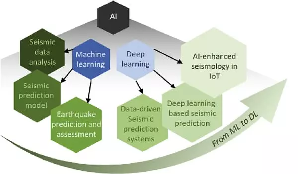
Because natural disasters are caused by geodynamic activities or abnormal changes in the environment, geological hazards have the potential to devastate both the environment and human society. Recently, the dramatic increase in the volume of various types of Earth observation “big data” from multiple sources, combined with the rapid development of deep learning as a cutting-edge data analysis tool, has enabled novel advances in geological hazard analysis, with the ultimate goal of mitigating the devastation associated with these hazards.
To process all of this data, the Los Alamos team created the first tool based on machine learning algorithms to extract ground deformation from InSAR data, allowing for the detection of ground deformation on a global scale without the need for human intervention. This tool, which is equipped with autonomous detection of deformation on faults, can help close the detection gap and lay the groundwork for a systematic exploration of the properties of active faults.
Systematically characterizing slip behavior on active faults is critical to understanding the physics of tectonic faulting and will aid researchers in understanding the interplay between slow earthquakes, which release stress gently, and fast earthquakes, which release stress quickly and can cause significant damage to surrounding communities.
The team’s new methodology detects ground deformation on a global scale automatically, with much finer temporal resolution than existing approaches and a detection threshold of a few millimeters. Previously, detection thresholds were measured in centimeters.
When seismic monitoring is used for emergency response, all parties involved should be aware of what is and is not possible. While earthquake prediction is extremely unreliable, other useful information can be provided both before and after an earthquake.
Because gravity changes propagate at the speed of light, gravity perturbations caused by earthquake deformation have the potential to enable faster alerts than the current seismic wave-based earthquake early warning systems. The method reaches two-millimeter detection in preliminary results, applied to data over the North Anatolian Fault, revealing a slow earthquake twice as extensive as previously recognized.
Because seismic waves travel so quickly, earthquake warnings can only be issued in exceptional circumstances. A seismograph network close to the earthquake may provide enough time for the surrounding region to take action. A generator, for example, maybe disconnected from a turbine to prevent damage. Offshore earthquakes in Japan may be detected in time to slow high-speed trains. A warning system in Mexico City detects large earthquakes to the south and gives people up to a minute to prepare for the arrival of seismic waves. Tsunami warning systems are useful because seismic sea waves from distant earthquakes typically travel at only a few hundred kilometers per hour, providing multiple hours of warning.